
Birds, Bats, and Beyond: Networked Wildlife Tracking in the Southern California Bight
Seabird and bat researchers from the USGS Western Ecological Research Center are teaming up to study how flying animals move through the marine environment. This Bureau of Ocean Energy Management supported project will add 25 remote telemetry stations to the existing global Motus Wildlife Tracking System, representing the largest single investment in coastal and offshore Motus infrastructure on the U.S. West Coast.
The Motus Wildlife Tracking System (www.motus.org; hereafter, Motus) is an international collaborative research network that uses coordinated, automated very high frequency (VHF) and ultra-high frequency (UHF) radio-telemetry arrays to study movements of small flying animals including birds, bats, and insects. These small-bodied animals have been challenging to study in the past because other tracking devices are too large for them to carry. Motus arrays are made up of automated radio telemetry receiving stations that detect signals from tiny tags worn by animals. The receiving stations are deployed and maintained by collaborators around the world. Everyone shares the receivers and the data! Information collected helps fill critical data gaps on wildlife movement and behavior, especially for small-bodied animals.

How does Motus detect animal movements?
The animal tracking devices or “tags” detected by the Motus network are tiny but mighty! Commercially available tags weigh as little as a single raindrop and can last from as short as 20 days to as long as the life of the animal, depending on the model. This means even a dragonfly can safely carry a tag detectable by the Motus network. When tagged animals move past receiving stations, a unique code is logged specific to that individual. Depending on the number and direction of antennas, researchers can deduce the animal’s direction of travel. If multiple towers detect the tagged individual at the same time, the animal’s location can be determined even more precisely.
Which species will USGS researchers study, and what do they hope to learn?
USGS WERC researchers plan to study three species of bats (Hoary Bat, Western Red Bat, and Mexican Free-tailed Bat) and three species of seabirds (Cassin’s Auklet, Ashy Storm-petrel, and Western Gull) using the Motus network. Western Gulls, which are a larger species of seabird, will carry GPS tags capable of detecting Motus tags, thereby acting as mobile receiving stations and expanding the network’s reach offshore.

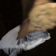

Species images: Above--Hoary bat with Motus transmitter, Western red bat being released, Mexican free-tailed bat. Below--Cassin's auklet with radio transmitter, Ashy storm-petrel, Western gull.


Objectives:

1. Expand Motus and networked tracking capabilities along the Pacific coast, especially
within the Southern California Bight area, the productive marine environment between Santa Barbara and Baja California.
2. Evaluate a suite of seabird and bat species using Motus to establish best practices and generate new methodologies (e.g., functionality of the tags on diving seabird species, comparison of tag types, and increased networked capacity for telemetry).
3. Foster collaboration with a variety of partners to enhance a tracking network in the Pacific Region.
4. Support greater regional data-collection efforts on the timing and scale of movements for shorebirds, marine birds, migratory bats, and other taxa in relation to offshore energy and other coastal development projects.
This capacity-building project will help researchers fill critical data gaps about offshore bat movement and seabird habitat use ahead of potential offshore energy development off the west coast.
Partners:
- Bureau of Ocean Energy Management
- Bureau of Land Management
- California Department of Fish and Wildlife
- California State Parks
- Motus Wildlife Tracking Network
- National Park Service
- The Nature Conservancy
- U.S. Airforce
- U.S. Fish and Wildlife Service
- U.S. Navy
Seabird and bat researchers from the USGS Western Ecological Research Center are teaming up to study how flying animals move through the marine environment. This Bureau of Ocean Energy Management supported project will add 25 remote telemetry stations to the existing global Motus Wildlife Tracking System, representing the largest single investment in coastal and offshore Motus infrastructure on the U.S. West Coast.
The Motus Wildlife Tracking System (www.motus.org; hereafter, Motus) is an international collaborative research network that uses coordinated, automated very high frequency (VHF) and ultra-high frequency (UHF) radio-telemetry arrays to study movements of small flying animals including birds, bats, and insects. These small-bodied animals have been challenging to study in the past because other tracking devices are too large for them to carry. Motus arrays are made up of automated radio telemetry receiving stations that detect signals from tiny tags worn by animals. The receiving stations are deployed and maintained by collaborators around the world. Everyone shares the receivers and the data! Information collected helps fill critical data gaps on wildlife movement and behavior, especially for small-bodied animals.
How does Motus detect animal movements?
The animal tracking devices or “tags” detected by the Motus network are tiny but mighty! Commercially available tags weigh as little as a single raindrop and can last from as short as 20 days to as long as the life of the animal, depending on the model. This means even a dragonfly can safely carry a tag detectable by the Motus network. When tagged animals move past receiving stations, a unique code is logged specific to that individual. Depending on the number and direction of antennas, researchers can deduce the animal’s direction of travel. If multiple towers detect the tagged individual at the same time, the animal’s location can be determined even more precisely.
Which species will USGS researchers study, and what do they hope to learn?
USGS WERC researchers plan to study three species of bats (Hoary Bat, Western Red Bat, and Mexican Free-tailed Bat) and three species of seabirds (Cassin’s Auklet, Ashy Storm-petrel, and Western Gull) using the Motus network. Western Gulls, which are a larger species of seabird, will carry GPS tags capable of detecting Motus tags, thereby acting as mobile receiving stations and expanding the network’s reach offshore.
Species images: Above--Hoary bat with Motus transmitter, Western red bat being released, Mexican free-tailed bat. Below--Cassin's auklet with radio transmitter, Ashy storm-petrel, Western gull.
Objectives:
1. Expand Motus and networked tracking capabilities along the Pacific coast, especially
within the Southern California Bight area, the productive marine environment between Santa Barbara and Baja California.
2. Evaluate a suite of seabird and bat species using Motus to establish best practices and generate new methodologies (e.g., functionality of the tags on diving seabird species, comparison of tag types, and increased networked capacity for telemetry).
3. Foster collaboration with a variety of partners to enhance a tracking network in the Pacific Region.
4. Support greater regional data-collection efforts on the timing and scale of movements for shorebirds, marine birds, migratory bats, and other taxa in relation to offshore energy and other coastal development projects.
This capacity-building project will help researchers fill critical data gaps about offshore bat movement and seabird habitat use ahead of potential offshore energy development off the west coast.
Partners:
- Bureau of Ocean Energy Management
- Bureau of Land Management
- California Department of Fish and Wildlife
- California State Parks
- Motus Wildlife Tracking Network
- National Park Service
- The Nature Conservancy
- U.S. Airforce
- U.S. Fish and Wildlife Service
- U.S. Navy