
Las Moras Wash Restoration: Integrated Geomorphic Assessment, Modeling, Monitoring, and Adaptive Management
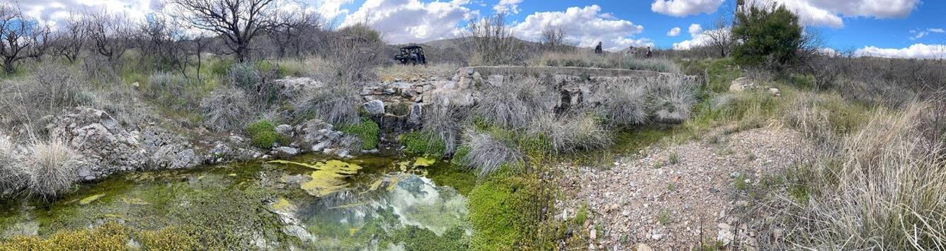
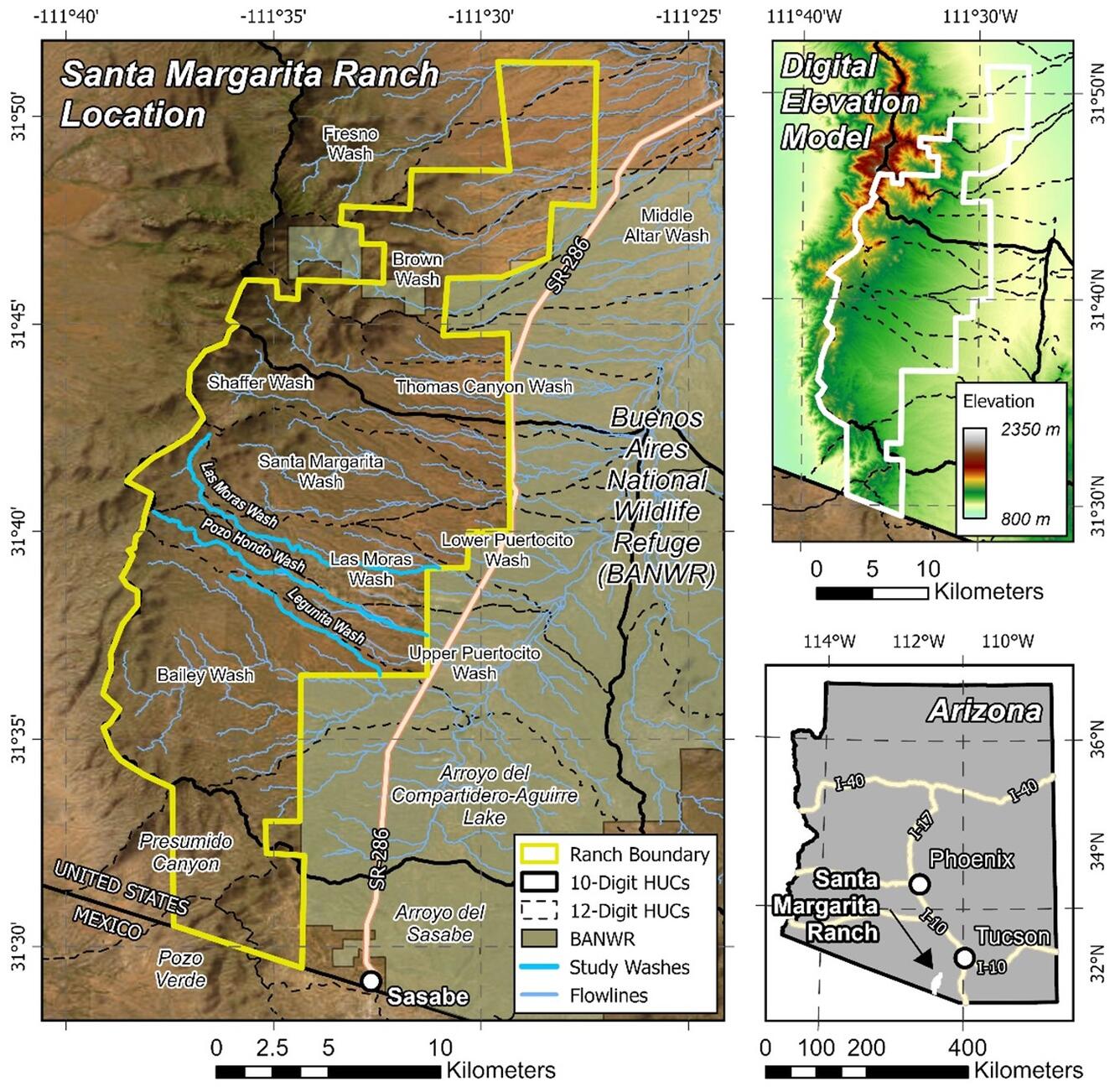
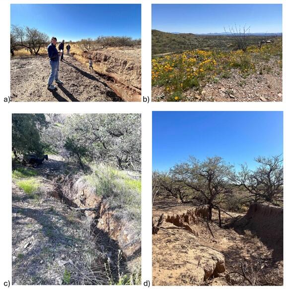
The Las Moras Wash, within the Santa Margarita Ranch, Altar Valley, AZ, exhibits channel incision, gully expansion, head‑cut migration, vegetation loss, and reduced hydrologic connectivity between upper watershed and floodplains.
Las Moras Wash Restoration: Integrated Geomorphic Assessment, Modeling, Monitoring, and Adaptive Management
By Western Geographic Science Center March 24, 2026
The Las Moras Wash, within the Santa Margarita Ranch, Altar Valley, AZ, exhibits channel incision, gully expansion, head‑cut migration, vegetation loss, and reduced hydrologic connectivity between upper watershed and floodplains (Figs. 1 & 2).
The project will install Natural Infrastructure in Dryland Streams (NIDS)—including one‑rock dams, check dams, gabions, brush structures, and leaky weirs—to slow runoff, trap sediment, enhance infiltration, rebuild alluvial soils, and restore ecohydrologic function in degraded arid systems.
Purpose. Integrate geomorphic diagnosis, spatial analysis, hydraulic & watershed modeling, field monitoring, and adaptive management to evaluate NIDS performance and landscape scale effects—producing high quality, defensible outcomes across geomorphic, hydrologic, and ecological domains.
NIDS Installation
Watershed Management Group (WMG) will lead hands‑on construction of Natural Infrastructure in Dryland Streams (NIDS) by guiding crews in placing rock, woody material, and grade‑control structures at strategic points throughout the treated watershed. Their work involves preparing sites, shaping channels, and installing features such as one‑rock dams, media lunas, brush weirs, and other low‑tech structures designed to slow water, spread flows, and capture sediment. WMG also ensures each structure is properly keyed into the banks and aligned to maintain stability and direct runoff safely during storms. Through this field‑based role, they help restore floodplain connectivity, support vegetation recovery, and set up the watershed for long‑term monitoring and adaptive management.
Research Methods & Instruments
Hydraulic & Watershed Modeling (University of Arizona | Civil and Architectural Engineering and Mechanics)
- HEC‑RAS 2D for reach‑scale hydraulics and shear stress mapping
- SWAT+ for watershed‑scale runoff, sediment yield, and water budget assessment
Paired watershed approach links treatment vs. control for defensible comparisons.
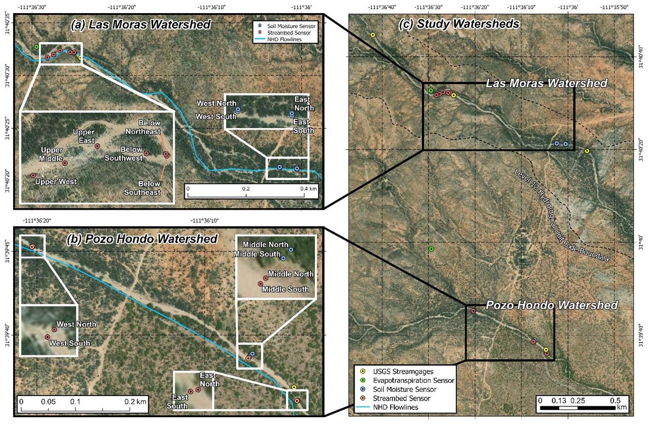
Monitoring Network (Figure 3)
- Evapotranspiration (ET) towers
- Soil‑moisture & streambed sensors
- Stream gages (stage/discharge)
- Pozo Hondo Wash Near Sasabe, AZ - USGS Water Data for the Nation
- Las Moras Wash (Lower Station) Near Sasabe, AZ - USGS Water Data for the Nation
- Las Moras Wash (Middle Station) Near Sasabe, AZ - USGS Water Data for the Nation
- Las Moras Wash (Upper Station) Near Sasabe, AZ - USGS Water Data for the Nation
QA/QC procedures and repeatable protocols to support adaptive management.
Activities and Deliverables
The project conducts integrated field surveys, remote sensing, modeling, restoration design, and monitoring to understand watershed conditions and evaluate NIDS‑based restoration strategies. Together, these activities produce baseline datasets, calibrated models, design packages, monitoring records, and final synthesis products that support adaptive management and collaborative decision‑making.
| Activity | Key Tasks | Deliverables |
| Hydrologic Monitoring & Water Budget Assessment | Coordinate four stream gages, ET towers, soil moisture and streambed sensors; integrate climate/ET datasets | Monitoring datasets; annual hydrologic/vegetation response reports |
| Baseline Characterization & Geomorphic Assessment | Field surveys of channel geometry, incision, soils, vegetation, disturbances; establish baseline hydrologic/geomorphic/vegetation datasets | Baseline datasets; geomorphic condition summary |
| Spatial Analysis & Remote Sensing | High‑resolution DEM analysis; gully/headcut mapping; priority restoration zone identification; integration of Sentinel‑2 land cover maps | GIS maps of erosion hotspots and restoration opportunities |
| Vegetation Modeling & Ecological Assessment | Analysis of land cover, vegetation condition, moisture indices; integrate ecological response with hydrologic/geomorphic data | Vegetation condition maps; ecological response assessment |
| Hydraulic & Watershed Modeling | 2D hydraulic modeling (HEC‑RAS 2D); watershed modeling (SWAT+); simulation of flow, shear stress, sediment dynamics | Calibrated models; structure placement guidance |
| Restoration Design & Implementation | Evaluate existing structures; design rock detention, grade control, woody structures, bank stabilization; guide installation planning | Restoration design packages; implementation plans |
| Adaptive Management & Decision Support | Link monitoring results to design refinement; prioritize maintenance; develop scaling strategy | Adaptive management framework |
| Partnerships & Collaboration | Lead coordination with USGS, UA, WMG, Santa Margarita Ranch, AVCA; meetings, workshops, reporting | Partner engagement documentation; meeting summaries |
| Project Reporting & Synthesis | Produce progress reports, annual summaries, and final synthesis of findings and transferable methods | Final synthesis report; data products; restoration guidance |
Timeline & Phases
Phase Structure
- Phase 1 (Completed in 2025): Design, installation, O&M of ecohydrological monitoring network at Las Moras Wash.
- Phase 2 (2026–2027): Baseline collection, modeling, restoration design, initial implementation, and setup of long‑term monitoring.
- Phase 3: NIDS installation ongoing; network O&M; data synthesis; model refinement; comprehensive analysis of hydrologic/geomorphic/vegetation/sediment outcomes.
- Phase 4: Manuscripts, final integrated datasets, publication of findings for transferability to arid/semi‑arid landscapes.
Partners & Collaborators
- Santa Margarita Ranch Inc.:Luis Solorzano, PhD · Austyn Henretta
- University of Arizona: Jennifer Duan, PhD · Iván López‑Castrillo · Kun Qi · Rowan Huang
- Watershed Management Group:Catlow Shipek
- Altar Valley Conservation Alliance
- U.S. Geological Survey: Roy Petrakis · Britt Smith, PhD · Miguel Villarreal, PhD · Raymond Lebeau · Natalie R. Wilson · Dan Evans · Robert Fritzinger · Alfonso Dominguez · Jay Cederberg · Kurt Ehrenberg
PRODUCTS
Lebeau, R., Norman, Laura M., & Villarreal, M. L. (2025). Vegetation and land use/land cover of the Altar Valley, AZ mapped from Sentinel-2 data (2024) [U.S. Geological Survey Data Release]. https://doi.org/10.5066/P13MLS8B
The Las Moras Wash, within the Santa Margarita Ranch, Altar Valley, AZ, exhibits channel incision, gully expansion, head‑cut migration, vegetation loss, and reduced hydrologic connectivity between upper watershed and floodplains.
Las Moras Wash Restoration: Integrated Geomorphic Assessment, Modeling, Monitoring, and Adaptive Management
By Western Geographic Science Center March 24, 2026
The Las Moras Wash, within the Santa Margarita Ranch, Altar Valley, AZ, exhibits channel incision, gully expansion, head‑cut migration, vegetation loss, and reduced hydrologic connectivity between upper watershed and floodplains (Figs. 1 & 2).
The project will install Natural Infrastructure in Dryland Streams (NIDS)—including one‑rock dams, check dams, gabions, brush structures, and leaky weirs—to slow runoff, trap sediment, enhance infiltration, rebuild alluvial soils, and restore ecohydrologic function in degraded arid systems.
Purpose. Integrate geomorphic diagnosis, spatial analysis, hydraulic & watershed modeling, field monitoring, and adaptive management to evaluate NIDS performance and landscape scale effects—producing high quality, defensible outcomes across geomorphic, hydrologic, and ecological domains.
NIDS Installation
Watershed Management Group (WMG) will lead hands‑on construction of Natural Infrastructure in Dryland Streams (NIDS) by guiding crews in placing rock, woody material, and grade‑control structures at strategic points throughout the treated watershed. Their work involves preparing sites, shaping channels, and installing features such as one‑rock dams, media lunas, brush weirs, and other low‑tech structures designed to slow water, spread flows, and capture sediment. WMG also ensures each structure is properly keyed into the banks and aligned to maintain stability and direct runoff safely during storms. Through this field‑based role, they help restore floodplain connectivity, support vegetation recovery, and set up the watershed for long‑term monitoring and adaptive management.
Research Methods & Instruments
Hydraulic & Watershed Modeling (University of Arizona | Civil and Architectural Engineering and Mechanics)
- HEC‑RAS 2D for reach‑scale hydraulics and shear stress mapping
- SWAT+ for watershed‑scale runoff, sediment yield, and water budget assessment
Paired watershed approach links treatment vs. control for defensible comparisons.
Monitoring Network (Figure 3)
- Evapotranspiration (ET) towers
- Soil‑moisture & streambed sensors
- Stream gages (stage/discharge)
- Pozo Hondo Wash Near Sasabe, AZ - USGS Water Data for the Nation
- Las Moras Wash (Lower Station) Near Sasabe, AZ - USGS Water Data for the Nation
- Las Moras Wash (Middle Station) Near Sasabe, AZ - USGS Water Data for the Nation
- Las Moras Wash (Upper Station) Near Sasabe, AZ - USGS Water Data for the Nation
QA/QC procedures and repeatable protocols to support adaptive management.
Activities and Deliverables
The project conducts integrated field surveys, remote sensing, modeling, restoration design, and monitoring to understand watershed conditions and evaluate NIDS‑based restoration strategies. Together, these activities produce baseline datasets, calibrated models, design packages, monitoring records, and final synthesis products that support adaptive management and collaborative decision‑making.
| Activity | Key Tasks | Deliverables |
| Hydrologic Monitoring & Water Budget Assessment | Coordinate four stream gages, ET towers, soil moisture and streambed sensors; integrate climate/ET datasets | Monitoring datasets; annual hydrologic/vegetation response reports |
| Baseline Characterization & Geomorphic Assessment | Field surveys of channel geometry, incision, soils, vegetation, disturbances; establish baseline hydrologic/geomorphic/vegetation datasets | Baseline datasets; geomorphic condition summary |
| Spatial Analysis & Remote Sensing | High‑resolution DEM analysis; gully/headcut mapping; priority restoration zone identification; integration of Sentinel‑2 land cover maps | GIS maps of erosion hotspots and restoration opportunities |
| Vegetation Modeling & Ecological Assessment | Analysis of land cover, vegetation condition, moisture indices; integrate ecological response with hydrologic/geomorphic data | Vegetation condition maps; ecological response assessment |
| Hydraulic & Watershed Modeling | 2D hydraulic modeling (HEC‑RAS 2D); watershed modeling (SWAT+); simulation of flow, shear stress, sediment dynamics | Calibrated models; structure placement guidance |
| Restoration Design & Implementation | Evaluate existing structures; design rock detention, grade control, woody structures, bank stabilization; guide installation planning | Restoration design packages; implementation plans |
| Adaptive Management & Decision Support | Link monitoring results to design refinement; prioritize maintenance; develop scaling strategy | Adaptive management framework |
| Partnerships & Collaboration | Lead coordination with USGS, UA, WMG, Santa Margarita Ranch, AVCA; meetings, workshops, reporting | Partner engagement documentation; meeting summaries |
| Project Reporting & Synthesis | Produce progress reports, annual summaries, and final synthesis of findings and transferable methods | Final synthesis report; data products; restoration guidance |
Timeline & Phases
Phase Structure
- Phase 1 (Completed in 2025): Design, installation, O&M of ecohydrological monitoring network at Las Moras Wash.
- Phase 2 (2026–2027): Baseline collection, modeling, restoration design, initial implementation, and setup of long‑term monitoring.
- Phase 3: NIDS installation ongoing; network O&M; data synthesis; model refinement; comprehensive analysis of hydrologic/geomorphic/vegetation/sediment outcomes.
- Phase 4: Manuscripts, final integrated datasets, publication of findings for transferability to arid/semi‑arid landscapes.
Partners & Collaborators
- Santa Margarita Ranch Inc.:Luis Solorzano, PhD · Austyn Henretta
- University of Arizona: Jennifer Duan, PhD · Iván López‑Castrillo · Kun Qi · Rowan Huang
- Watershed Management Group:Catlow Shipek
- Altar Valley Conservation Alliance
- U.S. Geological Survey: Roy Petrakis · Britt Smith, PhD · Miguel Villarreal, PhD · Raymond Lebeau · Natalie R. Wilson · Dan Evans · Robert Fritzinger · Alfonso Dominguez · Jay Cederberg · Kurt Ehrenberg
PRODUCTS
Lebeau, R., Norman, Laura M., & Villarreal, M. L. (2025). Vegetation and land use/land cover of the Altar Valley, AZ mapped from Sentinel-2 data (2024) [U.S. Geological Survey Data Release]. https://doi.org/10.5066/P13MLS8B