
Boreholes being drilled at Cinder Lake as part of a U.S. Geological Survey study to determine the feature's floodwater storage capacity. Cinder Lake, which is located on the Coconino National Forest, has been used to store runoff from areas affected by the 2010 Schultz Fire outside of Flagstaff, Arizona.
Jamie Macy
Jamie Macy is a Supervisory Hydrologist in the Arizona Water Science Center, Flagstaff Office
Science and Products
Las Moras Wash Restoration: Integrated Geomorphic Assessment, Modeling, Monitoring, and Adaptive Management
The Las Moras Wash, within the Santa Margarita Ranch, Altar Valley, AZ, exhibits channel incision, gully expansion, head‑cut migration, vegetation loss, and reduced hydrologic connectivity between upper watershed and floodplains.

Urban Waters Federal Partnership – Groundwater and Surface Water Characterization of the Lower Gila River for the Rio Salado Project
In partnership with the Flood Control District of Maricopa County and as part of the Urban Waters Federal Partnership, the US Geological Survey is collecting water-quality and water-level data to help characterize the shallow groundwater and surface water along the Lower Gila River. Water sampling and continuous monitoring of specific conductance, surface water, and shallow groundwater level...

Pipe Spring National Monument Groundwater Monitoring
Potential changes in groundwater levels in Pipe Spring National Monument are monitored via three observation wells by the U.S. Geological Survey (USGS) in cooperation with the National Park Service (NPS).

Hydrocarbon Monitoring in Response to Personal Watercraft Regulation at Glen Canyon National Recreation Area
Polycyclic aromatic hydrocarbon (PAH) contamination related to watercraft use is one of the most significant water-quality issues affecting Lake Powell at Glen Canyon National Recreation Area (GLCA). Water quality in Lake Powell is important as the lake is a water source for public and agricultural consumption. In addition, more than 2 million people visit GLCA annually, and most of these visitors...

C Aquifer Monitoring Program
The Navajo Nation, the City of Flagstaff (COF), and the U.S. Geological Survey (USGS) maintain a cooperative monitoring program with other local and State agencies for groundwater in the C aquifer (Coconino aquifer) in the Little Colorado River Basin. The goal of this program is to determine baseline groundwater conditions in the C aquifer and other water-bearing zones before significant...

Black Mesa Monitoring Program
The U.S. Geological Survey water-monitoring program in the Black Mesa area began in 1971 and provides information about the long-term effects of groundwater withdrawals from the N aquifer for industrial and municipal uses. The monitoring program includes measuring potential recovery in the N aquifer as a result of the reduction in industrial pumpage by Peabody Western Coal Company.

Drilling in Cinder Lake, Arizona
Boreholes being drilled at Cinder Lake as part of a U.S. Geological Survey study to determine the feature's floodwater storage capacity. Cinder Lake, which is located on the Coconino National Forest, has been used to store runoff from areas affected by the 2010 Schultz Fire outside of Flagstaff, Arizona.

Mountain Sheep Spring, Arizona
Mountain Sheep Spring, Arizona, is one of the 37 springs north of the Grand Canyon near areas of breccia-pipe uranium mining that U.S. Geological Survey (USGS) scientists studied.
Mountain Sheep Spring, Arizona, is one of the 37 springs north of the Grand Canyon near areas of breccia-pipe uranium mining that U.S. Geological Survey (USGS) scientists studied.

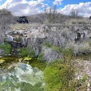
Schmutz Spring, Arizona
Schmutz Spring, Arizona, is one of the 37 springs north of the Grand Canyon near areas of breccia-pipe uranium mining that U.S. Geological Survey (USGS) scientists studied.
Schmutz Spring, Arizona, is one of the 37 springs north of the Grand Canyon near areas of breccia-pipe uranium mining that U.S. Geological Survey (USGS) scientists studied.
Science and Products
Las Moras Wash Restoration: Integrated Geomorphic Assessment, Modeling, Monitoring, and Adaptive Management
The Las Moras Wash, within the Santa Margarita Ranch, Altar Valley, AZ, exhibits channel incision, gully expansion, head‑cut migration, vegetation loss, and reduced hydrologic connectivity between upper watershed and floodplains.
Urban Waters Federal Partnership – Groundwater and Surface Water Characterization of the Lower Gila River for the Rio Salado Project
In partnership with the Flood Control District of Maricopa County and as part of the Urban Waters Federal Partnership, the US Geological Survey is collecting water-quality and water-level data to help characterize the shallow groundwater and surface water along the Lower Gila River. Water sampling and continuous monitoring of specific conductance, surface water, and shallow groundwater level...
Pipe Spring National Monument Groundwater Monitoring
Potential changes in groundwater levels in Pipe Spring National Monument are monitored via three observation wells by the U.S. Geological Survey (USGS) in cooperation with the National Park Service (NPS).
Hydrocarbon Monitoring in Response to Personal Watercraft Regulation at Glen Canyon National Recreation Area
Polycyclic aromatic hydrocarbon (PAH) contamination related to watercraft use is one of the most significant water-quality issues affecting Lake Powell at Glen Canyon National Recreation Area (GLCA). Water quality in Lake Powell is important as the lake is a water source for public and agricultural consumption. In addition, more than 2 million people visit GLCA annually, and most of these visitors...
C Aquifer Monitoring Program
The Navajo Nation, the City of Flagstaff (COF), and the U.S. Geological Survey (USGS) maintain a cooperative monitoring program with other local and State agencies for groundwater in the C aquifer (Coconino aquifer) in the Little Colorado River Basin. The goal of this program is to determine baseline groundwater conditions in the C aquifer and other water-bearing zones before significant...
Black Mesa Monitoring Program
The U.S. Geological Survey water-monitoring program in the Black Mesa area began in 1971 and provides information about the long-term effects of groundwater withdrawals from the N aquifer for industrial and municipal uses. The monitoring program includes measuring potential recovery in the N aquifer as a result of the reduction in industrial pumpage by Peabody Western Coal Company.
Drilling in Cinder Lake, Arizona
Boreholes being drilled at Cinder Lake as part of a U.S. Geological Survey study to determine the feature's floodwater storage capacity. Cinder Lake, which is located on the Coconino National Forest, has been used to store runoff from areas affected by the 2010 Schultz Fire outside of Flagstaff, Arizona.
Boreholes being drilled at Cinder Lake as part of a U.S. Geological Survey study to determine the feature's floodwater storage capacity. Cinder Lake, which is located on the Coconino National Forest, has been used to store runoff from areas affected by the 2010 Schultz Fire outside of Flagstaff, Arizona.
Mountain Sheep Spring, Arizona
Mountain Sheep Spring, Arizona, is one of the 37 springs north of the Grand Canyon near areas of breccia-pipe uranium mining that U.S. Geological Survey (USGS) scientists studied.
Mountain Sheep Spring, Arizona, is one of the 37 springs north of the Grand Canyon near areas of breccia-pipe uranium mining that U.S. Geological Survey (USGS) scientists studied.
Schmutz Spring, Arizona
Schmutz Spring, Arizona, is one of the 37 springs north of the Grand Canyon near areas of breccia-pipe uranium mining that U.S. Geological Survey (USGS) scientists studied.
Schmutz Spring, Arizona, is one of the 37 springs north of the Grand Canyon near areas of breccia-pipe uranium mining that U.S. Geological Survey (USGS) scientists studied.