Scientists from across USGS have created the first CONUS-wide collection of key tidal wetland metrics. These metrics provide data on habitat quality, geomorphic vulnerability, and carbon stock that are necessary to understand the current and future ecosystem services provided by coastal wetlands.

Healthy coastal wetlands provide numerous socioeconomic and ecological benefits to coastal communities, including storm surge and flooding protection, pollution filtration, and recreational opportunities.
The U.S. Coastal Wetland Geospatial Collection provides the data necessary to assess the health status of coastal wetlands throughout the contiguous United States and to understand the current and future services provided by these ecosystems.
The collection represents the first CONUS-wide dataset for these key tidal wetland metrics, which provide data on habitat quality, geomorphic vulnerability, and carbon stock that are necessary to understand current and future services provided by coastal wetlands. A combination of satellite, aircraft-based lidar, and tidal gauge data were used to obtain geospatially complete data across the coastal landscape. Comparing spatial relationships between datasets will allow basic research into biogeomorphic processes of wetlands.
“We have over 4 million acres of tidal wetlands in the conterminous USA, and this data collection opens up new avenues for tracking wetland quality, vulnerability, and potential change over that whole area. Putting all of these data in a centralized location will make it easier for researchers and coastal managers to visualize and analyze biogeomorphic patterns in tidal wetlands across the Nation,” said Neil Kamal Ganju, a Research Oceanographer for the USGS Woods Hole Coastal and Marine Science Center.
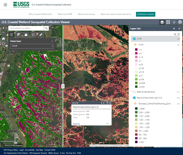
Navigating the U.S. Coastal Wetland Geospatial Collection
The collection highlights the value of USGS coastal wetland research and allows users to access three national datasets, including relative tidal elevation, unvegetated-vegetated marsh ratio (UVVR), and above-ground biomass, at 30-meter resolution. Each dataset can be viewed on its own interactive map or all three can be viewed together in the Collection viewer.
To accompany the datasets, there is a coastal wetlands geonarrative titled “Why Coastal Wetlands?”, which details the importance of wetlands, the different threats they face, and what USGS is doing to provide coastal managers with the information they need to safeguard these ecosystems and the numerous services they provide to communities.
Users can navigate the collection by clicking on the tiles on the cover page or the tabbed menu that appears once you have made an initial selection.
In the Collection viewer, users can use a swipe tool to compare layers and click to see the values for each pixel. Users can also add other data to the viewer and bookmark any locations of interest.