
Coastal Landscape- Change Predictions
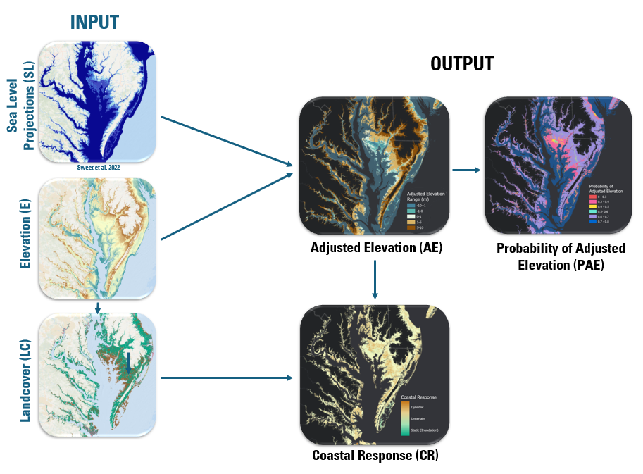
Sea-level rise (SLR) impacts on the coastal landscape are presented here as: 1) level of landscape submergence (adjusted land elevation with respect to projected mean high water levels); and 2) coastal response type characterized as either static (for example, inundation) or dynamic (for example, landform or landscape change). Results are produced at a spatial scale of 10 meters for four decades (the 2030s, 2050s, 2080s and 2100s) for the Northeastern U.S. Predicted outcomes can be linked with habitat vulnerability information and used to develop adaptive management and resource allocation strategies at regional and local levels that can aid interagency and interdisciplinary management planning efforts.
The datasets are intended to integrate with habitat models produced by others to meet decision making needs. For example, SLR scenarios are produced for time periods that either match those being used by collaborators or are generally common planning horizons for decision makers. SLR scenarios used as model inputs are derived from the 2022 interagency report, Global and Regional Sea Level Rise Scenarios for the United States (NOAA Technical Report NOS 01), developed by the U.S. Sea Level Rise and Coastal Flood Hazard Scenarios and Tools Interagency Task Force. This report provides regionally downscaled projections of relative sea level for U.S. coastlines at decadal time steps that integrate global mean sea-level rise scenarios informed by the Intergovernmental Panel on Climate Change Sixth Assessment Report (AR6) with regional adjustments that account for oceanographic processes, gravitational and rotational effects, and vertical land motion. For the purposes of this model, the Intermediate Low and Intermediate High scenarios are used to represent a range of plausible futures, evaluated at the years 2030, 2050, 2080, and 2100.
The use of high-quality elevation data allows the projection of water level increases across the landscape to define a general level of potential submergence. The land cover base map from a corresponding habitat impacts model is used to ensure results are produced at a resolution and coverage readily usable by collaborators; land cover information from this map is coupled with landscape submergence information to identify environment types likely to dynamically respond vs. inundate. All datasets are used to develop a predictive model (a Bayesian network) that integrates the sea-level, elevation and land cover data with coastal response probabilities that account for interactions with coastal geomorphology as well as the corresponding ecological and societal systems it supports.