
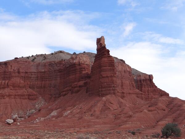
A view of a sandstone spire in Capitol Reef National Park. This area, known as the Fruita, is made up of three primary layers. The bottom sandstone layer is known as the Moenkopi Formation and is about 245 million years old. The middle gray-green layer is known as the Chinle Formation and was laid down as volcanic ash about 225 million years ago.
Images
Images
Filter Total Items: 9454
Sandstone Spire in Capitol Reef
A view of a sandstone spire in Capitol Reef National Park. This area, known as the Fruita, is made up of three primary layers. The bottom sandstone layer is known as the Moenkopi Formation and is about 245 million years old. The middle gray-green layer is known as the Chinle Formation and was laid down as volcanic ash about 225 million years ago.

Capitol Reef Cliff
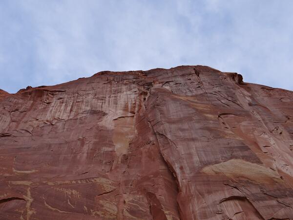
A sandstone cliff near the entrance of Capitol Reef National Park. Capitol Reef is primarily made up of sandstone formations within the Waterpocket Fold, monocline that extends nearly 100 miles. A monocline is a step-like fold in rock strata that can resemble an enormous wrinkle in the earth. The tracks on the cliff are from off-road vehicles.
A sandstone cliff near the entrance of Capitol Reef National Park. Capitol Reef is primarily made up of sandstone formations within the Waterpocket Fold, monocline that extends nearly 100 miles. A monocline is a step-like fold in rock strata that can resemble an enormous wrinkle in the earth. The tracks on the cliff are from off-road vehicles.

Capitol Reef Cliff
A sandstone cliff near the entrance of Capitol Reef National Park. Capitol Reef is primarily made up of sandstone formations within the Waterpocket Fold, monocline that extends nearly 100 miles. A monocline is a step-like fold in rock strata that can resemble an enormous wrinkle in the earth. This land is managed by the Bureau of Land Management.
A sandstone cliff near the entrance of Capitol Reef National Park. Capitol Reef is primarily made up of sandstone formations within the Waterpocket Fold, monocline that extends nearly 100 miles. A monocline is a step-like fold in rock strata that can resemble an enormous wrinkle in the earth. This land is managed by the Bureau of Land Management.

Grand Staircase-Escalante
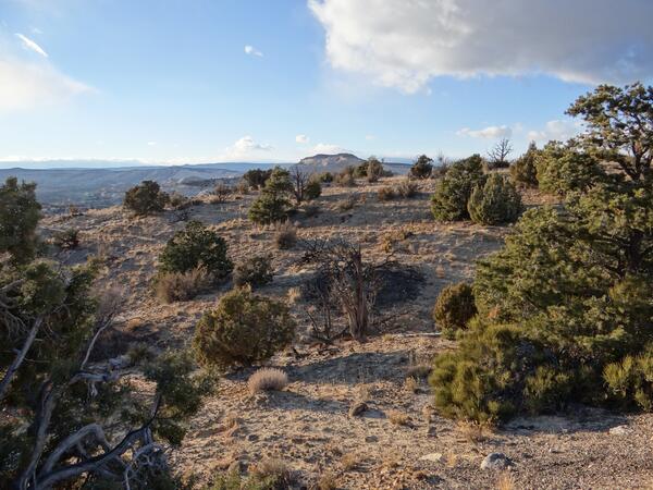
A landscape view from State Route 12 through the Grand Staircase-Escalante National Monument. Grand Staircase-Escalante encompasses the largest land area of all U.S. National Monuments.
A landscape view from State Route 12 through the Grand Staircase-Escalante National Monument. Grand Staircase-Escalante encompasses the largest land area of all U.S. National Monuments.

Grand Staircase-Escalante
A landscape view from State Route 12 through the Grand Staircase-Escalante National Monument. Grand Staircase-Escalante encompasses the largest land area of all U.S. National Monuments.
A landscape view from State Route 12 through the Grand Staircase-Escalante National Monument. Grand Staircase-Escalante encompasses the largest land area of all U.S. National Monuments.

Grand Staircase-Escalante
A panorama view from State Route 12 through the Grand Staircase-Escalante National Monument. Grand Staircase-Escalante encompasses the largest land area of all U.S. National Monuments.
A panorama view from State Route 12 through the Grand Staircase-Escalante National Monument. Grand Staircase-Escalante encompasses the largest land area of all U.S. National Monuments.

Grand Staircase-Escalante
A landscape view from State Route 12 through the Grand Staircase-Escalante National Monument. Grand Staircase-Escalante encompasses the largest land area of all U.S. National Monuments.
A landscape view from State Route 12 through the Grand Staircase-Escalante National Monument. Grand Staircase-Escalante encompasses the largest land area of all U.S. National Monuments.

Capitol Reef Cliff
A sandstone cliff near the entrance of Capitol Reef National Park. Capitol Reef is primarily made up of sandstone formations within the Waterpocket Fold, monocline that extends nearly 100 miles. A monocline is a step-like fold in rock strata that can resemble an enormous wrinkle in the earth. This land is managed by the Bureau of Land Management.
A sandstone cliff near the entrance of Capitol Reef National Park. Capitol Reef is primarily made up of sandstone formations within the Waterpocket Fold, monocline that extends nearly 100 miles. A monocline is a step-like fold in rock strata that can resemble an enormous wrinkle in the earth. This land is managed by the Bureau of Land Management.

Grand Staircase-Escalante
A panorama view from State Route 12 through the Grand Staircase-Escalante National Monument. Grand Staircase-Escalante encompasses the largest land area of all U.S. National Monuments.
A panorama view from State Route 12 through the Grand Staircase-Escalante National Monument. Grand Staircase-Escalante encompasses the largest land area of all U.S. National Monuments.

Grand Staircase-Escalante
A landscape view from State Route 12 through the Grand Staircase-Escalante National Monument. Grand Staircase-Escalante encompasses the largest land area of all U.S. National Monuments.
A landscape view from State Route 12 through the Grand Staircase-Escalante National Monument. Grand Staircase-Escalante encompasses the largest land area of all U.S. National Monuments.
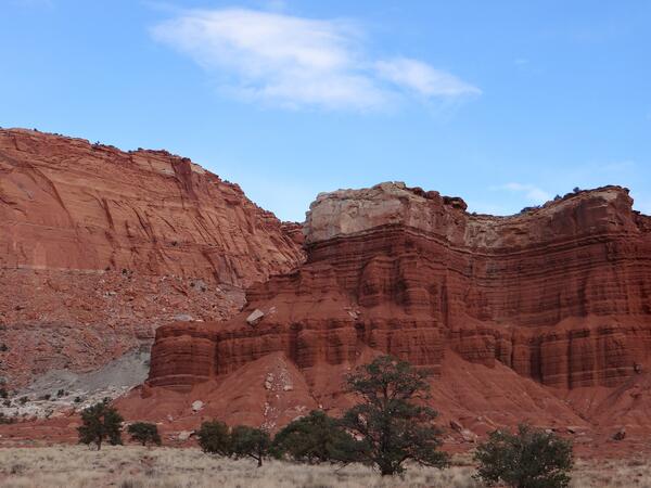
Sandstone Cliff in Capitol Reef
A sandstone cliff in Capitol Reef National Park. Capitol Reef is primarily made up of sandstone formations within the Waterpocket Fold, monocline that extends nearly 100 miles. A monocline is a step-like fold in rock strata that can resemble an enormous wrinkle in the earth.
A sandstone cliff in Capitol Reef National Park. Capitol Reef is primarily made up of sandstone formations within the Waterpocket Fold, monocline that extends nearly 100 miles. A monocline is a step-like fold in rock strata that can resemble an enormous wrinkle in the earth.
Grand Staircase-Escalante
A landscape view from State Route 12 through the Grand Staircase-Escalante National Monument. Grand Staircase-Escalante encompasses the largest land area of all U.S. National Monuments.
A landscape view from State Route 12 through the Grand Staircase-Escalante National Monument. Grand Staircase-Escalante encompasses the largest land area of all U.S. National Monuments.
Sandstone Formations in Capitol Reef
Capitol Reef is primarily made up of sandstone formations within the Waterpocket Fold, monocline that extends nearly 100 miles. A monocline is a step-like fold in rock strata that can resemble an enormous wrinkle in the earth.
Capitol Reef is primarily made up of sandstone formations within the Waterpocket Fold, monocline that extends nearly 100 miles. A monocline is a step-like fold in rock strata that can resemble an enormous wrinkle in the earth.

Capitol Reef Panorama
A panorama of some of the sandstone formations within Capitol Reef National Park. Capitol Reef is primarily made up of sandstone formations within the Waterpocket Fold, monocline that extends nearly 100 miles. A monocline is a step-like fold in rock strata that can resemble an enormous wrinkle in the earth.
A panorama of some of the sandstone formations within Capitol Reef National Park. Capitol Reef is primarily made up of sandstone formations within the Waterpocket Fold, monocline that extends nearly 100 miles. A monocline is a step-like fold in rock strata that can resemble an enormous wrinkle in the earth.

Capitol Reef Petroglyphs
From about 300-1300 CE, ancestors of the Hopi Tribe, Pueblo of Zuni, and Paiute Tribe lived in Capitol Reef. They are known by various names-archeologists call them the Fremont Culture; the Hopi Tribe calls them the Hisatsinom, or the "People of Long Ago;" and the Paiute Tribe calls them the Wee Noonts, or the "People Who Lived the Old Ways."
From about 300-1300 CE, ancestors of the Hopi Tribe, Pueblo of Zuni, and Paiute Tribe lived in Capitol Reef. They are known by various names-archeologists call them the Fremont Culture; the Hopi Tribe calls them the Hisatsinom, or the "People of Long Ago;" and the Paiute Tribe calls them the Wee Noonts, or the "People Who Lived the Old Ways."
Grand Staircase-Escalante Panorama
A panorama view from State Route 12 through the Grand Staircase-Escalante National Monument. Grand Staircase-Escalante encompasses the largest land area of all U.S. National Monuments.
A panorama view from State Route 12 through the Grand Staircase-Escalante National Monument. Grand Staircase-Escalante encompasses the largest land area of all U.S. National Monuments.

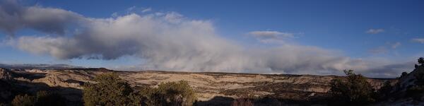
Panorama of Arches National Park
A panorama of Arches National Park. A snowstorm is gathering in the distance on the right.
A panorama of Arches National Park. A snowstorm is gathering in the distance on the right.

Sandstone Formation in Arches National Park
A sandstone formation in Arches National Park.
A sandstone formation in Arches National Park.
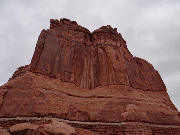
Sandstone Tower in Arches National Park
A sandstone tower in Arches National Park
A sandstone tower in Arches National Park
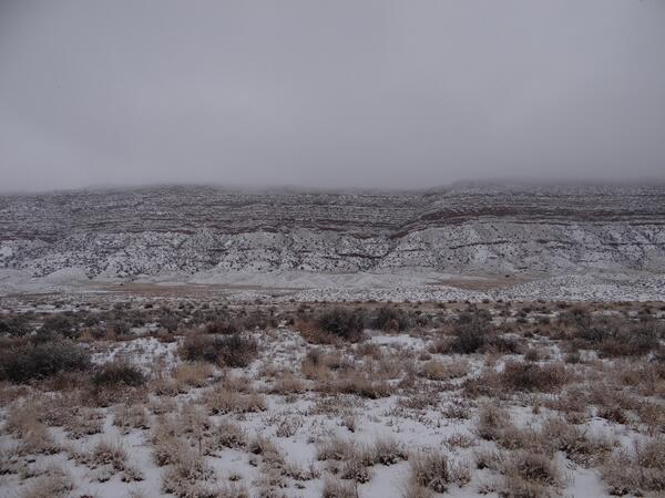
Snow-covered Sandstone Cliff
A snow-covered sandstone cliff in Arches National Park.
A snow-covered sandstone cliff in Arches National Park.
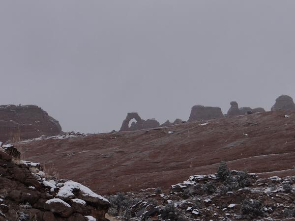
Delicate Arch in the Snow
Delicate Arch, one of the most famous of the more than 2,000 natural sandstone arches in Arches National Park.
Delicate Arch, one of the most famous of the more than 2,000 natural sandstone arches in Arches National Park.