
Glen Black of GLSC and Angela Wahlquist of Northland College places fyke net in wetland vegetation in Fish Creek Slough of Lake Superior near Ashland, Wisconsin, as part of a study of bioindicators of wetland degradation in the Great Lakes. This study is funded by the U.S.
Images
Images
Filter Total Items: 9448

Placing a Fyke Net in Wetland Vegetation
Glen Black of GLSC and Angela Wahlquist of Northland College places fyke net in wetland vegetation in Fish Creek Slough of Lake Superior near Ashland, Wisconsin, as part of a study of bioindicators of wetland degradation in the Great Lakes. This study is funded by the U.S.

Conducting a Breeding Bird Survey
Wildlife Biologist Bruce Hanson conducting a breeding bird survey.
Wildlife Biologist Bruce Hanson conducting a breeding bird survey.

Earthquake and Landslides in the Union of the Comoros
Earthquake and Landslides in the Union of the ComorosHeavy rains from a tropical cyclone struck the islands of the Comoros in March, 2014. On the island of Anjouan in the Union of Comoros, these rains triggered landslides that displaced over 3000 people to refugee camps.

Earthquake and Landslides in the Union of the Comoros
Earthquake and Landslides in the Union of the ComorosHeavy rains from a tropical cyclone struck the islands of the Comoros in March, 2014. On the island of Anjouan in the Union of Comoros, these rains triggered landslides that displaced over 3000 people to refugee camps. The USGS and the OFDA with USAID are providing support and research assistance on these events.

Earthquake and Landslides in the Union of the Comoros
Earthquake and Landslides in the Union of the ComorosHeavy rains from a tropical cyclone struck the islands of the Comoros in March, 2014. On the island of Anjouan in the Union of Comoros, these rains triggered landslides that displaced over 3000 people to refugee camps.

Goats Foraging
Goats forage in an Argan tree.
Goats forage in an Argan tree.

Goats Foraging
Goats forage in an Argan tree.
Goats forage in an Argan tree.

Goats Foraging
Goats forage in an Argan tree.
Goats forage in an Argan tree.

Goats Foraging
Goats forage in an Argan tree.
Goats forage in an Argan tree.

Capybara (Hydrochoerus hydrochaeris)
Capybara rests in its enclosure in a zoological park, it's the world's largest rodent.
Capybara rests in its enclosure in a zoological park, it's the world's largest rodent.

Northern Leopard Frog
Northern Leopard Frog (Rana pipiens).
Northern Leopard Frog (Rana pipiens).

Scientist Taking Water Samples
Todd Preston, USGS contract scientist, collecting a surface-water sample from a Prairie Pothole wetland.
Todd Preston, USGS contract scientist, collecting a surface-water sample from a Prairie Pothole wetland.

Placing Invertebrate Traps in a Pond
Graduate student Christiane Roy placing suspended invertebrate traps in the experimental ponds by kayak.
Graduate student Christiane Roy placing suspended invertebrate traps in the experimental ponds by kayak.

Light Meter near Mangrove Corals
Underwater light sensor deployed under the mangrove canopy where corals are growing.
Underwater light sensor deployed under the mangrove canopy where corals are growing.

American Bullfrog
A biologist examines an American bullfrog along the Yellowstone River near Billings, MT.
A biologist examines an American bullfrog along the Yellowstone River near Billings, MT.

Gray jay
Gray jay perched on tree in the Presidential Range, White Mountains, NH
Gray jay perched on tree in the Presidential Range, White Mountains, NH
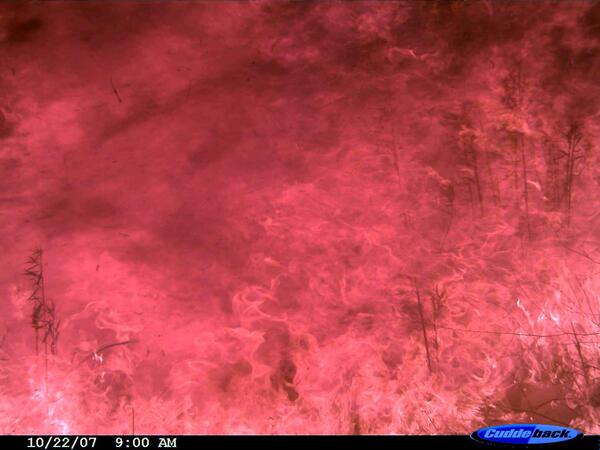
High-Intensity Wildfire Flames
After the photo of the coyote on the run, the next photo on the camera shows high-intensity flames at 9:00 a.m. PST on Oct. 22, 2007. Photo credit: USGS.
After the photo of the coyote on the run, the next photo on the camera shows high-intensity flames at 9:00 a.m. PST on Oct. 22, 2007. Photo credit: USGS.

Transition Zone Between Dams on the Upper Missouri River
Transition Zone Between Dams on the Upper Missouri RiverThe transition zone between the Missouri River and Ft. Peck Reservoir.
Transition Zone Between Dams on the Upper Missouri River
Transition Zone Between Dams on the Upper Missouri RiverThe transition zone between the Missouri River and Ft. Peck Reservoir.

Wind Turbine and Forest
Two wind turbines from side on clear day.
Two wind turbines from side on clear day.