
Blue morpho butterfly resting on a leaf with wings open.
Images
Images
Filter Total Items: 9454

Blue Morpho (Morpho peleides)
Blue morpho butterfly resting on a leaf with wings open.

Blue Morpho (Morpho peleides)
Blue morpho butterfly resting on a leaf with wings open.
Blue morpho butterfly resting on a leaf with wings open.

Blue Morpho (Morpho peleides)
Blue morpho butterfly resting on a leaf with wings closed.
Blue morpho butterfly resting on a leaf with wings closed.

Blue Morpho (Morpho peleides)
Blue morpho butterfly resting on a leaf with wings open.
Blue morpho butterfly resting on a leaf with wings open.

Cushioned star (Oreaster reticulatus)
Cushion star on the ocean floor.

Cushioned star (Oreaster reticulatus)
Cushion star on the ocean floor.

Blue Morpho (Morpho peleides)
Blue morpho butterfly resting on a leaf with wings open.
Blue morpho butterfly resting on a leaf with wings open.

USGS Gage and Sun River at Simms, MT
Taken while on the 2007 SW review of the Montana Science Center.
Taken while on the 2007 SW review of the Montana Science Center.

Missouri River Near Ulm, MT
View of river from the gage location looking downstream.
View of river from the gage location looking downstream.

Muddy Creek at Vaughn, MT
View of gage and stream.

Missouri River at Ft. Benton, MT
View of USGS gage on the Missouri River at Ft. Benton, MT.
View of USGS gage on the Missouri River at Ft. Benton, MT.

Stories of Lava Flows and Volcanic Landscapes from Ka'u to North Kona Featured in Public Talk
Stories of Lava Flows and Volcanic Landscapes from Ka'u to North Kona Featured in Public TalkTwo prominent, historic lava flows are visible in this aerial photo of West Hawai‘i. Kīholo Bay is flanked by the 1859 Mauna Loa flow (left) and a Hualālai flow that erupted around 1800 or earlier (right). These lava flows and other volcanic landscapes along Highways 11 and 190 will be the focus of a Volcano Awareness Month talk in Kona on Jan. 22

Rio Grande, San Luis Hills, and Blanca Peak in San Luis Basin
Rio Grande, San Luis Hills, and Blanca Peak in San Luis BasinPhoto captures the Rio Grande, volcanic San Luis Hills, and Blanca Peak massif in the San Luis Basin, part of the Rio Grande rift. The basin - currently being studied by the USGS - is of interest for groundwater, petroleum, and mineral resources.

Map it Out
USGS, DNR, Fish and wildlife service plan a study on the Spring River. A Tri state study
USGS, DNR, Fish and wildlife service plan a study on the Spring River. A Tri state study
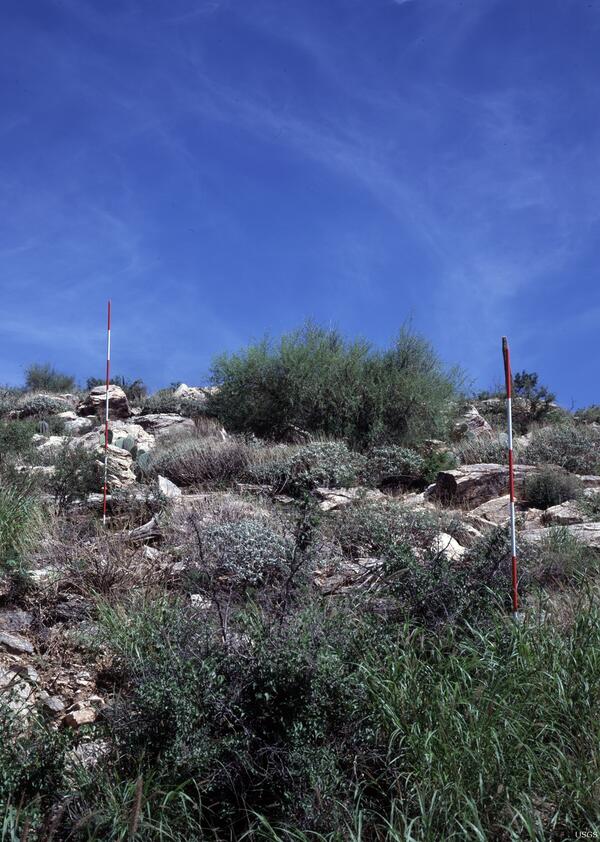
Santa Catalina Highway, near Tucson, Southern Arizona - 2006
Santa Catalina Highway, near Tucson, Southern Arizona - 2006Two ranging poles were placed near the positions of two sets of saguaros in order to determine their heights, and hence approximate ages. Most were established in the 1890s, after livestock grazing and the removal of fine fuels had begun in the area.

Scientists Explore Alaska's Coast
This oblique aerial photograph is of Flaxman Island off the Alaska coast and shows a tapped thermokarst lakes, caribou tracks and ice-rich bluffs that are eroding.
This oblique aerial photograph is of Flaxman Island off the Alaska coast and shows a tapped thermokarst lakes, caribou tracks and ice-rich bluffs that are eroding.

Caribou Tracks Along Alaska's Coast
This photograph shows caribou tracks on ice-wedge polygons near Garry Creek in Alaska. Coastal erosion along the Arctic coast is chronic, widespread and potentially accelerating, posing threats to infrastructure important for defense and energy purposes, natural shoreline habitats and nearby Native communities.
This photograph shows caribou tracks on ice-wedge polygons near Garry Creek in Alaska. Coastal erosion along the Arctic coast is chronic, widespread and potentially accelerating, posing threats to infrastructure important for defense and energy purposes, natural shoreline habitats and nearby Native communities.

Eroding Shoreline Along Alaska's Coast
This photograph shows ice-wedge polygons and an eroding shoreline at Cape Halkett on the Beaufort Sea coast of Alaska. Coastal erosion along the Arctic coast is chronic, widespread and potentially accelerating, posing threats to infrastructure important for defense and energy purposes, natural shoreline habitats and nearby Native communities.
This photograph shows ice-wedge polygons and an eroding shoreline at Cape Halkett on the Beaufort Sea coast of Alaska. Coastal erosion along the Arctic coast is chronic, widespread and potentially accelerating, posing threats to infrastructure important for defense and energy purposes, natural shoreline habitats and nearby Native communities.

Long-Range Radar Station and Landfill
This oblique aerial photograph from 2006 shows the Barter Island long-range radar station landfill threatened by coastal erosion. The landfill was subsequently relocated further inland, however, the coastal bluffs continue to retreat.
This oblique aerial photograph from 2006 shows the Barter Island long-range radar station landfill threatened by coastal erosion. The landfill was subsequently relocated further inland, however, the coastal bluffs continue to retreat.

Polar Bear Along Alaska's Coast
A polar bear stands on a low-lying barrier shoal near the Huluhula River on the Beaufort Sea coast of Alaska. Coastal erosion along the Arctic coast is chronic, widespread and potentially accelerating, posing threats to infrastructure important for defense and energy purposes, natural shoreline habitats and nearby Native communities.
A polar bear stands on a low-lying barrier shoal near the Huluhula River on the Beaufort Sea coast of Alaska. Coastal erosion along the Arctic coast is chronic, widespread and potentially accelerating, posing threats to infrastructure important for defense and energy purposes, natural shoreline habitats and nearby Native communities.