
Field trip to Death Valley. Jim Crowley (USGS), Giles Marion (Desert Research Institute), John Mars (USGS).
Images
Images
Filter Total Items: 9454

Death Valley
Field trip to Death Valley. Jim Crowley (USGS), Giles Marion (Desert Research Institute), John Mars (USGS).

Death Valley
Field trip to Death Valley. John Mars (USGS). Giles Marion (Desert Research Institute), Jim Crowley (USGS), Simon Hook (JPL).
Field trip to Death Valley. John Mars (USGS). Giles Marion (Desert Research Institute), Jim Crowley (USGS), Simon Hook (JPL).

Three Bottle-Fed Baby Goats
Baby goats in Texas that were rejected by their various mothers, being fed bottled milk.
Baby goats in Texas that were rejected by their various mothers, being fed bottled milk.

Baling Hay
Loading hay from a field in East Texas.
Loading hay from a field in East Texas.

Baling Hay
Loading hay from a field in East Texas.
Loading hay from a field in East Texas.

Streamflow-gaging station 08096500 Brazos River at Waco
Streamflow-gaging station 08096500 Brazos River at WacoU.S. Geological Survey streamflow-gaging station 08096500 Brazos River at Waco, Texas, photograph looking upstream at the Brazos River (Lake Brazos) from the State Loop 340 bridge, October 25, 2006.
SIR 2009–5174

U.S. Geological Survey streamflow-gaging station 080305
U.S. Geological Survey streamflow-gaging station 080305U.S. Geological Survey streamflow-gaging station 08030500 Sabine River near Ruliff, Texas, photograph looking from left bank adjacent to State Highway 12 bridge, October 24, 2006.
SIR 2009–5174

Burning Sagebrush
This is sagebrush burning at Hart Mountain National Antelope Refuge in association with a management project located 65 miles northeast of Lakeview, OR.
This is sagebrush burning at Hart Mountain National Antelope Refuge in association with a management project located 65 miles northeast of Lakeview, OR.
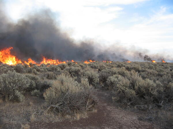
Controlled burn at Hart Mountain National Wildlife Refuge.
Controlled burn at Hart Mountain National Wildlife Refuge.Wildfire is one of the largest sources of re-released mercury to the atmosphere and a component to the widespread movement of inorganic mercury to aquatic sediments.
Controlled burn at Hart Mountain National Wildlife Refuge.
Controlled burn at Hart Mountain National Wildlife Refuge.Wildfire is one of the largest sources of re-released mercury to the atmosphere and a component to the widespread movement of inorganic mercury to aquatic sediments.

Brewer's Sparrow Surveys
Conducing Brewer's sparrow (Spizella breweri) surveys in sagebrush habitat, Owyhee Moutains, SW Idaho.
Conducing Brewer's sparrow (Spizella breweri) surveys in sagebrush habitat, Owyhee Moutains, SW Idaho.

New Afghanistan Geological Survey Building
New AGS building after USAID renovation features cutting edge scientific equipment.
New AGS building after USAID renovation features cutting edge scientific equipment.
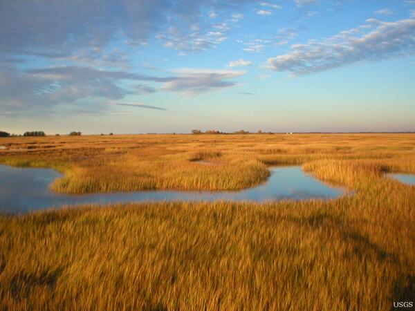
Tidal Marshland in the Plum Island Estuary, Massachusetts
Tidal Marshland in the Plum Island Estuary, MassachusettsThe marshes of Plum Island Estuary are among those predicted by scientists to submerge during the next century under conservative projections of sea-level rise.
Tidal Marshland in the Plum Island Estuary, Massachusetts
Tidal Marshland in the Plum Island Estuary, MassachusettsThe marshes of Plum Island Estuary are among those predicted by scientists to submerge during the next century under conservative projections of sea-level rise.

Costa's Hummingbird (Calypte costae)
Costa's hummingbird perched on twig.
Costa's hummingbird perched on twig.
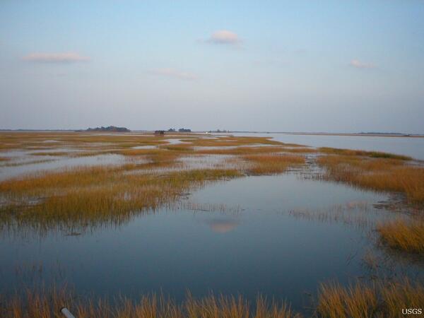
Tidal Marshland in the Plum Island Estuary, Massachusetts
Tidal Marshland in the Plum Island Estuary, MassachusettsThe marshes of Plum Island Estuary are among those predicted by scientists to submerge during the next century under conservative projections of sea-level rise.
Tidal Marshland in the Plum Island Estuary, Massachusetts
Tidal Marshland in the Plum Island Estuary, MassachusettsThe marshes of Plum Island Estuary are among those predicted by scientists to submerge during the next century under conservative projections of sea-level rise.

Costa's Hummingbird (Calypte costae)
Costa's hummingbird in flight.

Costa's Hummingbird (Calypte costae)
Costa's hummingbird in flight.

Costa's Hummingbird (Calypte costae)
Close up of a Costa's hummingbird perched on twig.
Close up of a Costa's hummingbird perched on twig.
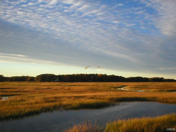
Tidal Marshland in the Plum Island Estuary, Massachusetts
Tidal Marshland in the Plum Island Estuary, MassachusettsThe marshes of Plum Island Estuary are among those predicted by scientists to submerge during the next century under conservative projections of sea-level rise.
Tidal Marshland in the Plum Island Estuary, Massachusetts
Tidal Marshland in the Plum Island Estuary, MassachusettsThe marshes of Plum Island Estuary are among those predicted by scientists to submerge during the next century under conservative projections of sea-level rise.

Costa's Hummingbird (Calypte costae)
Close up of a Costa's hummingbird perched on twig.
Close up of a Costa's hummingbird perched on twig.

Desert Cottontail (Sylvilagus audubonii) with Tick in Ear
Desert Cottontail (Sylvilagus audubonii) with Tick in EarSide-view of a desert Cottontail sitting on the ground with tick in ear
Desert Cottontail (Sylvilagus audubonii) with Tick in Ear
Desert Cottontail (Sylvilagus audubonii) with Tick in EarSide-view of a desert Cottontail sitting on the ground with tick in ear

Heermann's Gull (Larus heermanni)
A flock of heerman's gulls on the beach.
A flock of heerman's gulls on the beach.