
Ground Control Points
Ground Control Points (GCPs) are defined as points on the surface of the earth of known location used to geo-reference Landsat Level-1 data. GCPs are updated as needed to continually improve Landsat data. GCPs can be downloaded and used as reference data.
Ground Control Point Updates

In 2014, improvements to GCP files began – these include removing outdated files, and creating new, time-specific and seasonal GCPs.
Search for Ground Control Points

Use this tool to locate Ground Control Points for your WRS-2 Path/Row of interest.
Return to Landsat Geometry Overview
The USGS Landsat Image Assessment (IAS) and Landsat Product Generation System (LPGS) teams use a coordinate reference system for Landsat Level-1 products and Ground Control Points generation.
Landsat Ground Control Points Coordinate Reference System
The refrence system consists of map projection coordinates that fall on pixel-size (resolution) whole integers. Each pixel in Landsat 4-5 Thematic Mapper, Landsat 7 Enhanced Thematic Mapper Plus, and Landsat 8 Operational Land Imager/Thermal Infrared Sensor) products represents a 30 by 30-meter area on the surface of the Earth. This means both the X and Y map coordinates for the upper left pixel is a multiple of 30-meters. These coordinates are associated with the center of a pixel. (Landsat 1-3 Multispectral Scanner data pixels are 60-by-60-meters).
Two commonly-used definitions to describe the map coordinate of each pixel within an image are Pixel Is Area and Pixel Is Point:
- Pixel Is Area defines the map coordinate as the very upper-left corner of the 30-by-30-meter pixel.
- Pixel is Point defines the map coordinate as the center of the 30-by-30 meter pixel.
Landsat Level-1 products and Ground Control points are produced using Pixel Is Point, as the map coordinate of the center of the pixel for all 4 corners of the image is divisible by a whole number of the resolution of the band, therefore for each band, the corner coordinates are all divisible by 30, with a remainder of zero. The metadata file delivered with each Landsat Level-1 product defining the corner coordinates also list the product corners as Pixel is Point.
Software Package Considerations
Some image processing software packages use the Pixel Is Area designation, and users will need to make adjustments to use the data in the selected software.
Changing from either Pixel Is Point to Pixel Is Area or Pixel is Area to Pixel is Point involves adjusting the corner coordinates by one-half a pixel in both the line and sample directions. The graphic below displays these differences, and the adjustments needed to be made.
An example listing the GeoTiff information for a Landsat product is shown below, with the Pixel Is Point designation in bold:
Understanding a Landsat Ground Control Point
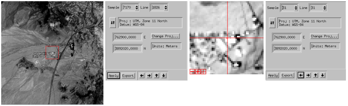
Landsat Ground Control Points are created using coordinate reference system described above. An example geographical representation and the metadata of a sample GCP file is displayed below to help understand the GCP file structure. NOTE: This sample GCP is not available and is shown as a reference only.
In this sample Path 39 Row 36 GCP, the image chip has a UTM map coordinate of 762900 X / 3892020 Y at the line and sample location (31,31) for a coordinate system whose upper left pixel is 0-relative with respect to line and sample (0,0). The map projection coordinate are the center of the pixel. This is represented in systems such as ENVI by listing the upper left coordinate as: map info = {UTM, 0.000, 0.000, Map Easting, Map Northing, 30.0, 30.0, 11, North, WGS-84, units=Meters}.
| Value | Metadata field description |
|---|---|
| 0390365454 | Unique Ground Control Point (GCP) ID - integer |
| Y | GCP Active Flag - string (Y/N) |
| 04-14-2021 | GCP date updated - string in form mm-dd-yyyy |
| NEW_POINT | GCP update reason - string |
| 1 | GCP version number - integer |
| 39 | GCP WRS-2 path - integer |
| 36 | GCP WRS-2 row - integer |
| GLS | GCP source - string |
| 35.1367489 | GCP latitude of reference point in degrees - double |
| -114.1145621 | GCP longitude of reference point in degrees - double |
| 840.000 | GCP elevation of reference point in meters - double |
| CONTROL | GCP type -string (CONTROL or VALIDATION) |
| 0390365454_01 | Image chip ID - string |
| Y | Image chip Active Flag - string (Y/N) |
| 04-14-2021 | Image chip date updated - string in form mm-dd-yyyy |
| 1 | Image chip version number - integer |
| 39 | Image chip source WRS-2 path - integer |
| 36 | Image chip source WRS-2 row - integer |
| 31.000000 | Image chip reference line - double |
| 31.000000 | Image chip reference sample - double |
| 762900.000 | Image chip reference point projection X in meters - double |
| 3892020.000 | Image chip reference point projection Y in meters - double |
| 30.000000 | Image chip pixel size x value in meters - double |
| 30.000000 | Image chip pixel size y value in meters - double |
| 64.000000 | Image chip size in lines - double |
| 64.000000 | Image chip size in samples - double |
| OLI | Image chip sensor - string |
| MORAVEC | Image chip selection method - string |
| 1 | Image chip Moravec rank if selection method is MORAVEC, zero otherwise - integer |
| UTM | Image chip projection - string |
| 11 | Image chip projection UTM zone - integer |
| ABS | Image chip type - string ABS (Absolute) or REL (relative) |
| 04-27-2018 | Image chip acquisition date - string in form mm-dd-yyyy |
| UI*2 | Image chip data type - string |
Improving Data with GCP Updates
In 2014, improvements to GCP files began – these include removing outdated files, and creating new, time-specific and seasonal GCPs. Visit Landsat Ground Control Points Updates for details about the changes made with each update.
Search for Landsat Ground Control Points
The Landsat Ground Control Point Search allows you to extract ground control point binary files over your area of interest.