
Las Vegas, Nevada and the area surrounding has been and remains a popular region of interest when showcasing urban growth and land change using Landsat sensors.
What are the processing levels for Landsat Level-1 data?
The table below shows the Landsat Collections Level-1 processing levels:
| Processing Level | Description |
|---|---|
| Terrain Precision Correction (L1TP) | Radiometrically calibrated and orthorectified using ground control points (GCPs) and digital elevation model (DEM) data to correct for relief displacement.The highest quality Level-1 products suitable for pixel-level time series analysis. |
| Systematic Terrain Correction (L1GT) | Radiometrically calibrated with systematic geometric corrections applied using the spacecraft ephemeris data and DEM data to correct for relief displacement. Note: L1GT are the highest level of radiometric calibration and systematic correction possible for Landsat 7 and Landsat 8 scenes collected over Antarctica. The L1GT product uses the high-resolution Radarsat Antarctic Mapping Project (RAMP) Version 2 as the elevation correction source. |
| Geometric Systematic Correction (L1GS) | Radiometrically calibration with only systematic geometric corrections applied using the spacecraft ephemeris data. |
* Layers previously referred to as NED are now branded as 3DEP seamless DEMs, part of the broader suite of products available from The National Map.
The processing level is noted in the metadata (.MTL.txt) file that is delivered with each Landsat Level-1 data product.
| GROUP = METADATA_FILE_INFO ORIGIN = "Image courtesy of the U.S. Geological Survey" REQUEST_ID = "2221601291006_00001" LANDSAT_SCENE_ID = "LT50470272010279PAC01" LANDSAT_PRODUCT_ID = "LT05_L1TP_047027_20101006_20160512_01_T1" COLLECTION_NUMBER = 01 FILE_DATE = 2016-05-12T13:14:46Z STATION_ID = "PAC" PROCESSING_SOFTWARE_VERSION = "LPGS_12.8.0" DATA_CATEGORY = "NOMINAL" END_GROUP = METADATA_FILE_INFO GROUP = PRODUCT_METADATA DATA_TYPE = "L1TP" DATA_TYPE_L0RP = "TMR_LORP" ELEVATION_SOURCE _ "GLS2000" OUTPUT_FORMAT = "GEOTIFF" EPHEMERIS_TYPE = "DEFINITIVE" SPACECRAFT_ID = "LANDSAT_5" SENSOR_ID = "TM" SENSOR_MODE = "BUMPER" WRS_PATH = 047 WRS_ROW = 027 DATE_ACQUIRED = 2010-10-06 SCENE_CENTER_TIME = "18:51:52.31601902" |
Related

Does Landsat Level-1 data processing include atmospheric correction? Does Landsat Level-1 data processing include atmospheric correction?
Landsat Level-1 data are not corrected for atmospheric conditions; however, Landsat Science Products are atmospherically corrected. Learn more: L andsat Level-1 data Landsat U.S. Analysis Ready Data Landsat Level-2 and Level-3 Science Products Landsat Data Access

How do I rescale Landsat Level-1 digital numbers to reflectance, radiance, and brightness temperature? How do I rescale Landsat Level-1 digital numbers to reflectance, radiance, and brightness temperature?
Landsat Level-1 data can be rescaled to the top of atmosphere (TOA) reflectance and/or radiance using radiometric rescaling coefficients provided in the metadata file (MTL.txt) that is delivered with the Landsat Level-1 product. The MTL file also contains the thermal constants needed to convert thermal band data to TOA brightness temperature (BT). Formulas for these conversions are at Using the...

How is the C Function of Mask algorithm used with Landsat Level-1 data? How is the C Function of Mask algorithm used with Landsat Level-1 data?
The C Function of Mask (CFMask) algorithm populates cloud, cloud confidence, cloud shadow, and snow/ice pixels in the processing of Landsat Collections Level-1 data products, with the results represented as bit-mapped values within the Landsat Collection 1 Level-1 Quality Assessment (QA) Band. CFMask derives from the Function of Mask (FMask), an algorithm written in MATLAB at Boston University and...

I have a list of historical Landsat Level-1 Scene IDs; how can I determine the corresponding Landsat Collections Level-1 Product Identifier? I have a list of historical Landsat Level-1 Scene IDs; how can I determine the corresponding Landsat Collections Level-1 Product Identifier?
The historical Landsat Level-1 Scene ID is in the EarthExplorer metadata. After entering a search using the historical Scene ID, the Landsat Level-1 Collection 1 Product Identifier will be returned in the search results. The results can be exported from EarthExplorer in a variety of formats for metadata parsing. We also encourage use of the Bulk Metadata Service to download files that contain both...

What is the naming convention for Landsat Collections Level-1 scenes? What is the naming convention for Landsat Collections Level-1 scenes?
The Landsat Collection 1 Level-1 product identifier includes the Collection processing levels, processing date, collection number, and collection tier category: LXSS_LLLL_PPPRRR_YYYYMMDD_yyyymmdd_CC_TX Where: L = Landsat X = Sensor (“C”=OLI/TIRS combined, “O”=OLI-only, “T”=TIRS-only, “E”=ETM+, “T”=“TM, “M”=MSS) SS = Satellite (”07”=Landsat 7, “08”=Landsat 8) LLL = Processing correction level (L1TP...

What are the Landsat Collection 1 Level-1 data product file sizes? What are the Landsat Collection 1 Level-1 data product file sizes?
The file sizes of Landsat Collection 1 Level-1 data products are listed below: Sensor Compressed file Uncompressed file Landsat 8 OLI/TIRS 919 MB 1.61 GB Landsat 7 ETM+ 235 MB 785 MB Landsat 4-5 TM 150 MB 500 MB Landsat 1-5 MSS 20 MB 75 MB

How does data from Sentinel-2A’s MultiSpectral Instrument compare to Landsat data? How does data from Sentinel-2A’s MultiSpectral Instrument compare to Landsat data?
The Sentinel-2A MultiSpectral Instrument (MSI) data has spectral bands very similar to Landsat 8 and 9 (excluding the thermal bands of Thermal Infrared Sensor (TIRS)). All Sentinel-2 data are freely available from the Copernicus Open Access Hub; therefore, users are encouraged to download the data via https://dataspace.copernicus.eu/explore-data/data-collections/sentinel-…. To learn...

Landsat 7 Images of Las Vegas, 1999-2024
Las Vegas, Nevada and the area surrounding has been and remains a popular region of interest when showcasing urban growth and land change using Landsat sensors.
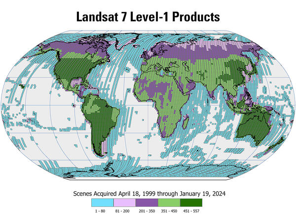
Landsat 7 Level-1 Products Available from USGS EROS
Landsat 7 Level-1 Products Available from USGS EROSNearly 3.4 million Landsat 7 Level-1 products are available for download from the USGS Earth Resources Observation and Science (EROS) Center archive. This map displays the density of the available Level-1 products acquired by Landsat 7 from April 1999 through January 2024.

Landsat Reveals Cape Cod's Changing Coastlines
Ocean currents, and the sediments they transport, have constantly shifted the Cape Cod barrier islands over time. Some of the abrupt changes, however, can be linked directly to a storm.
Ocean currents, and the sediments they transport, have constantly shifted the Cape Cod barrier islands over time. Some of the abrupt changes, however, can be linked directly to a storm.

Daily Operations of Landsat 7
What it takes each day to keep Landsat 7 operating smoothly. Hear the stories from inside the L7 Mission Operation Center.
What it takes each day to keep Landsat 7 operating smoothly. Hear the stories from inside the L7 Mission Operation Center.

Landsat in Action - Infrastructure of Landsat Data with Matt Hansen
Landsat in Action - Infrastructure of Landsat Data with Matt HansenMatt Hansen talks about the value of Landsat data as an infrastructure for research and innovation.
Landsat in Action - Infrastructure of Landsat Data with Matt Hansen
Landsat in Action - Infrastructure of Landsat Data with Matt HansenMatt Hansen talks about the value of Landsat data as an infrastructure for research and innovation.

Landsat in Action - The Accuracy of Landsat with Jeff Masek
Landsat in Action - The Accuracy of Landsat with Jeff MasekLandsat 9 Project Scientist Jeff Masek discusses the ways Landsat data is used and how important it is to have high quality data.
Landsat in Action - The Accuracy of Landsat with Jeff Masek
Landsat in Action - The Accuracy of Landsat with Jeff MasekLandsat 9 Project Scientist Jeff Masek discusses the ways Landsat data is used and how important it is to have high quality data.

Landsat's Calibration and Validation
Engineers and scientists from both Landsat and Sentinel missions are working together to calibrate observation data and validate its quality to improve the science using these resources.
Engineers and scientists from both Landsat and Sentinel missions are working together to calibrate observation data and validate its quality to improve the science using these resources.

Landsat Collections
Landsat Collections: Providing a Stable Environmental Record for Time Series Analysis
Landsat Collections: Providing a Stable Environmental Record for Time Series Analysis

Landsat Collections — What are Tiers?
This is the third video in a series describing the new U.S. Geological Survey (USGS) Landsat Collection 1 inventory structure. Collection 1 required the reprocessing of all archived Landsat data to achieve radiometric and geometric consistency of Level-1 products through time and across all Landsat sensors.
This is the third video in a series describing the new U.S. Geological Survey (USGS) Landsat Collection 1 inventory structure. Collection 1 required the reprocessing of all archived Landsat data to achieve radiometric and geometric consistency of Level-1 products through time and across all Landsat sensors.

Landsat Collections - RMSE
Landsat Collections: Providing a Stable Environment Record for Time Series Analysis
Landsat Collections: Providing a Stable Environment Record for Time Series Analysis
Related
Does Landsat Level-1 data processing include atmospheric correction? Does Landsat Level-1 data processing include atmospheric correction?
Landsat Level-1 data are not corrected for atmospheric conditions; however, Landsat Science Products are atmospherically corrected. Learn more: L andsat Level-1 data Landsat U.S. Analysis Ready Data Landsat Level-2 and Level-3 Science Products Landsat Data Access
How do I rescale Landsat Level-1 digital numbers to reflectance, radiance, and brightness temperature? How do I rescale Landsat Level-1 digital numbers to reflectance, radiance, and brightness temperature?
Landsat Level-1 data can be rescaled to the top of atmosphere (TOA) reflectance and/or radiance using radiometric rescaling coefficients provided in the metadata file (MTL.txt) that is delivered with the Landsat Level-1 product. The MTL file also contains the thermal constants needed to convert thermal band data to TOA brightness temperature (BT). Formulas for these conversions are at Using the...
How is the C Function of Mask algorithm used with Landsat Level-1 data? How is the C Function of Mask algorithm used with Landsat Level-1 data?
The C Function of Mask (CFMask) algorithm populates cloud, cloud confidence, cloud shadow, and snow/ice pixels in the processing of Landsat Collections Level-1 data products, with the results represented as bit-mapped values within the Landsat Collection 1 Level-1 Quality Assessment (QA) Band. CFMask derives from the Function of Mask (FMask), an algorithm written in MATLAB at Boston University and...
I have a list of historical Landsat Level-1 Scene IDs; how can I determine the corresponding Landsat Collections Level-1 Product Identifier? I have a list of historical Landsat Level-1 Scene IDs; how can I determine the corresponding Landsat Collections Level-1 Product Identifier?
The historical Landsat Level-1 Scene ID is in the EarthExplorer metadata. After entering a search using the historical Scene ID, the Landsat Level-1 Collection 1 Product Identifier will be returned in the search results. The results can be exported from EarthExplorer in a variety of formats for metadata parsing. We also encourage use of the Bulk Metadata Service to download files that contain both...
What is the naming convention for Landsat Collections Level-1 scenes? What is the naming convention for Landsat Collections Level-1 scenes?
The Landsat Collection 1 Level-1 product identifier includes the Collection processing levels, processing date, collection number, and collection tier category: LXSS_LLLL_PPPRRR_YYYYMMDD_yyyymmdd_CC_TX Where: L = Landsat X = Sensor (“C”=OLI/TIRS combined, “O”=OLI-only, “T”=TIRS-only, “E”=ETM+, “T”=“TM, “M”=MSS) SS = Satellite (”07”=Landsat 7, “08”=Landsat 8) LLL = Processing correction level (L1TP...
What are the Landsat Collection 1 Level-1 data product file sizes? What are the Landsat Collection 1 Level-1 data product file sizes?
The file sizes of Landsat Collection 1 Level-1 data products are listed below: Sensor Compressed file Uncompressed file Landsat 8 OLI/TIRS 919 MB 1.61 GB Landsat 7 ETM+ 235 MB 785 MB Landsat 4-5 TM 150 MB 500 MB Landsat 1-5 MSS 20 MB 75 MB
How does data from Sentinel-2A’s MultiSpectral Instrument compare to Landsat data? How does data from Sentinel-2A’s MultiSpectral Instrument compare to Landsat data?
The Sentinel-2A MultiSpectral Instrument (MSI) data has spectral bands very similar to Landsat 8 and 9 (excluding the thermal bands of Thermal Infrared Sensor (TIRS)). All Sentinel-2 data are freely available from the Copernicus Open Access Hub; therefore, users are encouraged to download the data via https://dataspace.copernicus.eu/explore-data/data-collections/sentinel-…. To learn...
Landsat 7 Images of Las Vegas, 1999-2024
Las Vegas, Nevada and the area surrounding has been and remains a popular region of interest when showcasing urban growth and land change using Landsat sensors.
Las Vegas, Nevada and the area surrounding has been and remains a popular region of interest when showcasing urban growth and land change using Landsat sensors.
Landsat 7 Level-1 Products Available from USGS EROS
Landsat 7 Level-1 Products Available from USGS EROSNearly 3.4 million Landsat 7 Level-1 products are available for download from the USGS Earth Resources Observation and Science (EROS) Center archive. This map displays the density of the available Level-1 products acquired by Landsat 7 from April 1999 through January 2024.
Landsat Reveals Cape Cod's Changing Coastlines
Ocean currents, and the sediments they transport, have constantly shifted the Cape Cod barrier islands over time. Some of the abrupt changes, however, can be linked directly to a storm.
Ocean currents, and the sediments they transport, have constantly shifted the Cape Cod barrier islands over time. Some of the abrupt changes, however, can be linked directly to a storm.
Daily Operations of Landsat 7
What it takes each day to keep Landsat 7 operating smoothly. Hear the stories from inside the L7 Mission Operation Center.
What it takes each day to keep Landsat 7 operating smoothly. Hear the stories from inside the L7 Mission Operation Center.
Landsat in Action - Infrastructure of Landsat Data with Matt Hansen
Landsat in Action - Infrastructure of Landsat Data with Matt HansenMatt Hansen talks about the value of Landsat data as an infrastructure for research and innovation.
Landsat in Action - Infrastructure of Landsat Data with Matt Hansen
Landsat in Action - Infrastructure of Landsat Data with Matt HansenMatt Hansen talks about the value of Landsat data as an infrastructure for research and innovation.
Landsat in Action - The Accuracy of Landsat with Jeff Masek
Landsat in Action - The Accuracy of Landsat with Jeff MasekLandsat 9 Project Scientist Jeff Masek discusses the ways Landsat data is used and how important it is to have high quality data.
Landsat in Action - The Accuracy of Landsat with Jeff Masek
Landsat in Action - The Accuracy of Landsat with Jeff MasekLandsat 9 Project Scientist Jeff Masek discusses the ways Landsat data is used and how important it is to have high quality data.
Landsat's Calibration and Validation
Engineers and scientists from both Landsat and Sentinel missions are working together to calibrate observation data and validate its quality to improve the science using these resources.
Engineers and scientists from both Landsat and Sentinel missions are working together to calibrate observation data and validate its quality to improve the science using these resources.
Landsat Collections
Landsat Collections: Providing a Stable Environmental Record for Time Series Analysis
Landsat Collections: Providing a Stable Environmental Record for Time Series Analysis
Landsat Collections — What are Tiers?
This is the third video in a series describing the new U.S. Geological Survey (USGS) Landsat Collection 1 inventory structure. Collection 1 required the reprocessing of all archived Landsat data to achieve radiometric and geometric consistency of Level-1 products through time and across all Landsat sensors.
This is the third video in a series describing the new U.S. Geological Survey (USGS) Landsat Collection 1 inventory structure. Collection 1 required the reprocessing of all archived Landsat data to achieve radiometric and geometric consistency of Level-1 products through time and across all Landsat sensors.
Landsat Collections - RMSE
Landsat Collections: Providing a Stable Environment Record for Time Series Analysis
Landsat Collections: Providing a Stable Environment Record for Time Series Analysis
Updated Date: July 17, 2025