Diagram showing the epicenter and hypocenter.
The epicenter is the point on the earth's surface vertically above the hypocenter (or focus), point in the crust where a seismic rupture begins.

Official websites use .gov
A .gov website belongs to an official government organization in the United States.
Secure .gov websites use HTTPS
A lock () or https:// means you’ve safely connected to the .gov website. Share sensitive information only on official, secure websites.
Earthquakes occur in the crust or upper mantle, which ranges from the earth's surface to about 800 kilometers deep (about 500 miles).
The strength of shaking from an earthquake diminishes with increasing distance from the earthquake's source, so the strength of shaking at the surface from an earthquake that occurs at 500 km deep is considerably less than if the same earthquake had occurred at 20 km depth.
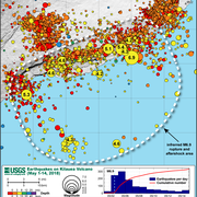
Also, the depths of earthquakes gives us important information about the Earth's structure and the tectonic setting where the earthquakes are occurring. The most prominent example of this is in subduction zones, where plates are colliding and one plate is being subducted beneath another. By carefully plotting the location and depth of earthquakes associated with a subduction zone, we can see details of the zone's structure, such as how steeply it is dipping, and if the down-going plate is planar or is bending. These details are important because they give us insight into the mechanics and characteristics of the deformation in the subduction zone.
The deepest earthquakes occur within the core of subducting slabs - oceanic plates that descend into the Earth's mantle from convergent plate boundaries, where a dense oceanic plate collides with a less dense continental plate and the former sinks beneath the latter. The plate boundary contact between two such plates generate very large, shallow subduction zone earthquakes such as the Sumatra 2004 M9.1 event, and the 2011 M9.0 Japan earthquake, and is only active to relatively shallow depths - approximately 60 km. However, because oceanic slabs are relatively cold with respect to the surrounding mantle in deeper subduction zone environments, faults within the core of these slab remain brittle and can generate earthquakes to depths of as much as 700 km (e.g., Pacific Plate beneath Japan and Kamchatka, and beneath Tonga).
As the slab descends into the mantle, rheology changes (viscosity characteristics) cause the plate to bend and deform, and generates these earthquakes. The trend of such events can be seen in cross-sections of subduction zones, and are known as "Wadati-Benioff Zones."
Within continents, and along continental plate boundary transform faults such as the San Andreas, faults are only active in the shallow crust - perhaps to depths of approximately 20 km.
Accurately determining the depth of an earthquake is typically more challenging than determining its location, unless there happens to be a seismic station close and above the epicenter. So generally, errors on depth determinations are somewhat greater than on location determinations.
Learn More: Glossary of earthquake terms

An earthquake is caused by a sudden slip on a fault. The tectonic plates are always slowly moving, but they get stuck at their edges due to friction. When the stress on the edge overcomes the friction, there is an earthquake that releases energy in waves that travel through the earth's crust and cause the shaking that we feel. In California there are two plates - the Pacific Plate and the North...
"Foreshock" and "aftershock" are relative terms. Foreshocks are earthquakes that precede larger earthquakes in the same location. An earthquake cannot be identified as a foreshock until after a larger earthquake in the same area occurs. Aftershocks are smaller earthquakes that occur in the same general area during the days to years following a larger event or "mainshock." They occur within 1-2...

Earthquakes are equally as likely to occur in the morning or the evening. Many studies in the past have shown no significant correlations between the rate of earthquake occurrence and the semi-diurnal tides when using large earthquake catalogs. Several recent studies, however, have found a correlation between earth tides (caused by the position of the moon relative to the earth) and some types of...
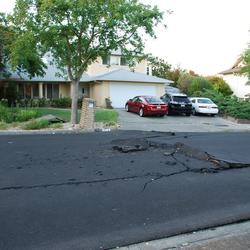
Surface rupture occurs when movement on a fault deep within the earth breaks through to the surface. NOT ALL earthquakes result in surface rupture.

An earthquake cannot physically occur at a depth of 0 km or -1km (above the surface of the earth). In order for an earthquake to occur, two blocks of crust must slip past one another, and it is impossible for this to happen at or above the surface of the earth. So why do we report that the earthquake occurred at a depth of 0 km or event as a negative depth sometimes? First of all, the depth of an...
Ten kilometers is a "fixed depth." Sometimes data are too poor to compute a reliable depth for an earthquake. In such cases, the depth is assigned to be 10 km. Why that number? In many areas around the world, reliable depths tend to average 10 km or close to it. For example, if we made a histogram of the reliable depths in such an area, we'd expect to see a peak around 10 km. So if we don't know...
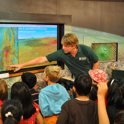
Start with our Earthquake Hazards Education site. That includes: Earthquakes for Kids Cool Earthquake Facts Earthquake Science for Everyone Other good starting points include: State Geological Surveys for states in earthquake-prone regions The Great ShakeOut Earthquake Drills website SAGE (Seismological Facility for the Advancement of Geoscience), which is a non-profit consortium
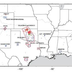
Earthquakes induced by human activity have been documented at many locations in the United States and in many other countries around the world. Earthquakes can be induced by a wide range of causes including impoundment of reservoirs, surface and underground mining, withdrawal of fluids and gas from the subsurface, and injection of fluids into underground formations. While most induced earthquakes...
Aftershocks are a sequence of earthquakes that happen after a larger mainshock on a fault. Aftershocks occur near the fault zone where the mainshock rupture occurred and are part of the "readjustment process” after the main slip on the fault. Aftershocks become less frequent with time, although they can continue for days, weeks, months, or even years for a very large mainshock. A swarm, on the...

Diagram showing the epicenter and hypocenter.
The epicenter is the point on the earth's surface vertically above the hypocenter (or focus), point in the crust where a seismic rupture begins.
Diagram showing the epicenter and hypocenter.
The epicenter is the point on the earth's surface vertically above the hypocenter (or focus), point in the crust where a seismic rupture begins.

Fault plane diagram. (Image courtesy of Kian H. Chong, Univ. of California, Davis)
Fault plane diagram. (Image courtesy of Kian H. Chong, Univ. of California, Davis)

Subduction zone of the Juan de Fuca Plate and North America Plate, creating the Mt. St. Helens and Mt. Hood volcanoes.
Subduction zone of the Juan de Fuca Plate and North America Plate, creating the Mt. St. Helens and Mt. Hood volcanoes.

Title: Where Earthquakes Hide in the Desert: What we've learned from recent fault ruptures in the western U.S.
By Austin J. Elliott, USGS Research Geologist
Title: Where Earthquakes Hide in the Desert: What we've learned from recent fault ruptures in the western U.S.
By Austin J. Elliott, USGS Research Geologist

View southward toward Mt. McGinnis and two large landslides on the northeastern side. These slides had roughly 40 million cubic meters of material and travelled 10 km down glacier. This is the cover photo of the May 16th, 2003, Science.
View southward toward Mt. McGinnis and two large landslides on the northeastern side. These slides had roughly 40 million cubic meters of material and travelled 10 km down glacier. This is the cover photo of the May 16th, 2003, Science.

Oblique aerial view of San Andreas Fault (between white arrows) in southeastern Coachella Valley, near Red Canyon; view to the west.
Oblique aerial view of San Andreas Fault (between white arrows) in southeastern Coachella Valley, near Red Canyon; view to the west.
An earthquake is caused by a sudden slip on a fault. The tectonic plates are always slowly moving, but they get stuck at their edges due to friction. When the stress on the edge overcomes the friction, there is an earthquake that releases energy in waves that travel through the earth's crust and cause the shaking that we feel. In California there are two plates - the Pacific Plate and the North...
"Foreshock" and "aftershock" are relative terms. Foreshocks are earthquakes that precede larger earthquakes in the same location. An earthquake cannot be identified as a foreshock until after a larger earthquake in the same area occurs. Aftershocks are smaller earthquakes that occur in the same general area during the days to years following a larger event or "mainshock." They occur within 1-2...
Earthquakes are equally as likely to occur in the morning or the evening. Many studies in the past have shown no significant correlations between the rate of earthquake occurrence and the semi-diurnal tides when using large earthquake catalogs. Several recent studies, however, have found a correlation between earth tides (caused by the position of the moon relative to the earth) and some types of...
Surface rupture occurs when movement on a fault deep within the earth breaks through to the surface. NOT ALL earthquakes result in surface rupture.
An earthquake cannot physically occur at a depth of 0 km or -1km (above the surface of the earth). In order for an earthquake to occur, two blocks of crust must slip past one another, and it is impossible for this to happen at or above the surface of the earth. So why do we report that the earthquake occurred at a depth of 0 km or event as a negative depth sometimes? First of all, the depth of an...
Ten kilometers is a "fixed depth." Sometimes data are too poor to compute a reliable depth for an earthquake. In such cases, the depth is assigned to be 10 km. Why that number? In many areas around the world, reliable depths tend to average 10 km or close to it. For example, if we made a histogram of the reliable depths in such an area, we'd expect to see a peak around 10 km. So if we don't know...
Start with our Earthquake Hazards Education site. That includes: Earthquakes for Kids Cool Earthquake Facts Earthquake Science for Everyone Other good starting points include: State Geological Surveys for states in earthquake-prone regions The Great ShakeOut Earthquake Drills website SAGE (Seismological Facility for the Advancement of Geoscience), which is a non-profit consortium
Earthquakes induced by human activity have been documented at many locations in the United States and in many other countries around the world. Earthquakes can be induced by a wide range of causes including impoundment of reservoirs, surface and underground mining, withdrawal of fluids and gas from the subsurface, and injection of fluids into underground formations. While most induced earthquakes...
Aftershocks are a sequence of earthquakes that happen after a larger mainshock on a fault. Aftershocks occur near the fault zone where the mainshock rupture occurred and are part of the "readjustment process” after the main slip on the fault. Aftershocks become less frequent with time, although they can continue for days, weeks, months, or even years for a very large mainshock. A swarm, on the...
Diagram showing the epicenter and hypocenter.
The epicenter is the point on the earth's surface vertically above the hypocenter (or focus), point in the crust where a seismic rupture begins.
Diagram showing the epicenter and hypocenter.
The epicenter is the point on the earth's surface vertically above the hypocenter (or focus), point in the crust where a seismic rupture begins.
Fault plane diagram. (Image courtesy of Kian H. Chong, Univ. of California, Davis)
Fault plane diagram. (Image courtesy of Kian H. Chong, Univ. of California, Davis)
Subduction zone of the Juan de Fuca Plate and North America Plate, creating the Mt. St. Helens and Mt. Hood volcanoes.
Subduction zone of the Juan de Fuca Plate and North America Plate, creating the Mt. St. Helens and Mt. Hood volcanoes.
Title: Where Earthquakes Hide in the Desert: What we've learned from recent fault ruptures in the western U.S.
By Austin J. Elliott, USGS Research Geologist
Title: Where Earthquakes Hide in the Desert: What we've learned from recent fault ruptures in the western U.S.
By Austin J. Elliott, USGS Research Geologist
View southward toward Mt. McGinnis and two large landslides on the northeastern side. These slides had roughly 40 million cubic meters of material and travelled 10 km down glacier. This is the cover photo of the May 16th, 2003, Science.
View southward toward Mt. McGinnis and two large landslides on the northeastern side. These slides had roughly 40 million cubic meters of material and travelled 10 km down glacier. This is the cover photo of the May 16th, 2003, Science.
Oblique aerial view of San Andreas Fault (between white arrows) in southeastern Coachella Valley, near Red Canyon; view to the west.
Oblique aerial view of San Andreas Fault (between white arrows) in southeastern Coachella Valley, near Red Canyon; view to the west.