
A new Worldwide Reference System, WRS-3, was developed for Landsat 10 due to the change in orbital parameters. The WRS-3 will provide a method to acquire, index, and catalog Landsat 10 scenes.
What is the Worldwide Reference System (WRS)?
The Worldwide Reference System (WRS) organizes Landsat imagery into a global grid, providing a consistent, reliable framework for locating, comparing, and analyzing data over time and across sensors.
WRS-1 was the first version of the grid, and it was used to collect imagery from Landsats 1, 2, and 3.
WRS-2 updated the original grid and is used by Landsats 4 through 9.
Landsat 10 is scheduled to launch in 2031, and will use WRS-3. Details about WRS-3 are being finalized and will be added to the reference pages listed below and on the Landsat 10 website when available.
Learn more:
Related

What are the band designations for the Landsat satellites? What are the band designations for the Landsat satellites?
The sensors onboard each of the Landsat satellites were designed to acquire data in different wavelengths within the electromagnetic spectrum. View Bandpass Wavelengths for all Landsat Sensors The Multispectral Scanner (MSS) carried on Landsat 1,2,3,4 and 5 collected data in four ranges (bands); the Thematic Mapper (TM) sensor on Landsat 4 and Landsat 5 included those bands found on earlier...

What are the best Landsat spectral bands for use in my research? What are the best Landsat spectral bands for use in my research?
The Spectral Characteristics Viewer is an interactive tool that can be used to visualize how the bands, or channels, of different satellite sensors measure the intensity of the many wavelengths (colors) of light. This is also known as the relative spectral response (RSR). By overlaying the spectral curves from different features (spectra), one can determine which bands of the selected sensor will...

How do I open Landsat satellite data files? How do I open Landsat satellite data files?
Many image processing programs can handle GeoTIFF and Cloud optimized GeoTIFF (COG) Landsat files, including free software like Multispec and QGIS. To view Landsat scenes without using specialized software, download Landsat Full Resolution browse images (.jpg) from EarthExplorer or GloVis. * The USGS does NOT endorse or support specific software packages. Any usability questions relating to...

What are some known issues that users might find in Landsat data? What are some known issues that users might find in Landsat data?
A number of artifacts and anomalies can happen to any remote sensing data. Banding, dropped scan lines, and detector failures are only a few of the anomalies that can be seen in Landsat data. Go to Landsat Known Issues for details about anomalies that have been discovered and investigated.

What are Landsat 5 TM "no-Payload Correction Data" scenes? What are Landsat 5 TM "no-Payload Correction Data" scenes?
Payload Correction Data (PCD) provides critical information when correcting for geometric distortions inherent to the imaging system and temperature values used to estimate per-scan gains and biases necessary for the radiometric calibration of the instrument's thermal band data. Over 260,000 Landsat 5 Thematic Mapper (TM) scenes acquired between January 1986 and December 1999, originally...

Are there any restrictions on the use or redistribution of Landsat data? Are there any restrictions on the use or redistribution of Landsat data?
There are no restrictions on Landsat data downloaded from the USGS; it can be used or redistributed as desired. We do request that you include a statement of the data source when citing, copying, or reprinting USGS Landsat data or images. Details are on the EROS Data Citation page. Learn more: USGS Copyrights and Credits statement
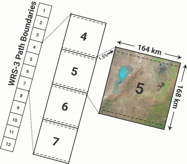
Worldwide Reference System-3 (WRS-3)
A new Worldwide Reference System, WRS-3, was developed for Landsat 10 due to the change in orbital parameters. The WRS-3 will provide a method to acquire, index, and catalog Landsat 10 scenes.
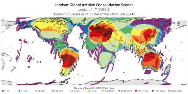
Landsat Global Archive Consolidation WRS 2 Scenes
This map displays the scenes acquired by Landsat 4, Landsat 5, and Landsat 7 satellites, on the World Reference System (WRS-2). These scenes were initially downlinked and stored at Landsat International Cooperator Ground Stations.
This map displays the scenes acquired by Landsat 4, Landsat 5, and Landsat 7 satellites, on the World Reference System (WRS-2). These scenes were initially downlinked and stored at Landsat International Cooperator Ground Stations.
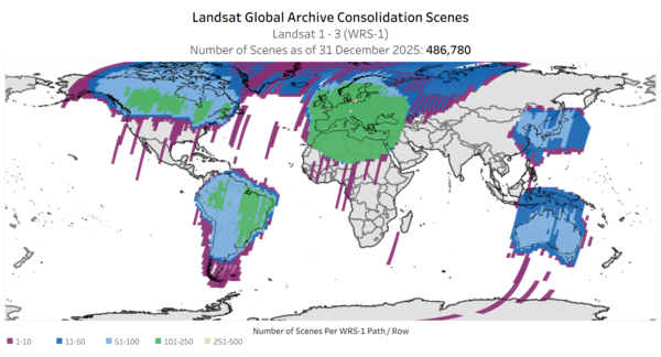
Landsat Global Archive Consolidation WRS 1 Scenes
This map displays the scenes acquired by Landsat 1, Landsat 2, and Landsat 3 satellites, on the World Reference System (WRS-1). These scenes were initially downlinked and stored at Landsat International Cooperator Ground Stations.
This map displays the scenes acquired by Landsat 1, Landsat 2, and Landsat 3 satellites, on the World Reference System (WRS-1). These scenes were initially downlinked and stored at Landsat International Cooperator Ground Stations.

Landsat in Action - Infrastructure of Landsat Data with Matt Hansen
Landsat in Action - Infrastructure of Landsat Data with Matt HansenMatt Hansen talks about the value of Landsat data as an infrastructure for research and innovation.
Landsat in Action - Infrastructure of Landsat Data with Matt Hansen
Landsat in Action - Infrastructure of Landsat Data with Matt HansenMatt Hansen talks about the value of Landsat data as an infrastructure for research and innovation.

Landsat in Action - The Accuracy of Landsat with Jeff Masek
Landsat in Action - The Accuracy of Landsat with Jeff MasekLandsat 9 Project Scientist Jeff Masek discusses the ways Landsat data is used and how important it is to have high quality data.
Landsat in Action - The Accuracy of Landsat with Jeff Masek
Landsat in Action - The Accuracy of Landsat with Jeff MasekLandsat 9 Project Scientist Jeff Masek discusses the ways Landsat data is used and how important it is to have high quality data.

Landsat in Action - The Importance of Landsat with Curtis Woodcock
Landsat in Action - The Importance of Landsat with Curtis WoodcockBoston University Professor Curtis Woodcock talks about the significance Landsat was had in science and what he hopes to see as the mission continues.
Landsat in Action - The Importance of Landsat with Curtis Woodcock
Landsat in Action - The Importance of Landsat with Curtis WoodcockBoston University Professor Curtis Woodcock talks about the significance Landsat was had in science and what he hopes to see as the mission continues.

Landsat's Calibration and Validation
Engineers and scientists from both Landsat and Sentinel missions are working together to calibrate observation data and validate its quality to improve the science using these resources.
Engineers and scientists from both Landsat and Sentinel missions are working together to calibrate observation data and validate its quality to improve the science using these resources.
Related
What are the band designations for the Landsat satellites? What are the band designations for the Landsat satellites?
The sensors onboard each of the Landsat satellites were designed to acquire data in different wavelengths within the electromagnetic spectrum. View Bandpass Wavelengths for all Landsat Sensors The Multispectral Scanner (MSS) carried on Landsat 1,2,3,4 and 5 collected data in four ranges (bands); the Thematic Mapper (TM) sensor on Landsat 4 and Landsat 5 included those bands found on earlier...
What are the best Landsat spectral bands for use in my research? What are the best Landsat spectral bands for use in my research?
The Spectral Characteristics Viewer is an interactive tool that can be used to visualize how the bands, or channels, of different satellite sensors measure the intensity of the many wavelengths (colors) of light. This is also known as the relative spectral response (RSR). By overlaying the spectral curves from different features (spectra), one can determine which bands of the selected sensor will...
How do I open Landsat satellite data files? How do I open Landsat satellite data files?
Many image processing programs can handle GeoTIFF and Cloud optimized GeoTIFF (COG) Landsat files, including free software like Multispec and QGIS. To view Landsat scenes without using specialized software, download Landsat Full Resolution browse images (.jpg) from EarthExplorer or GloVis. * The USGS does NOT endorse or support specific software packages. Any usability questions relating to...
What are some known issues that users might find in Landsat data? What are some known issues that users might find in Landsat data?
A number of artifacts and anomalies can happen to any remote sensing data. Banding, dropped scan lines, and detector failures are only a few of the anomalies that can be seen in Landsat data. Go to Landsat Known Issues for details about anomalies that have been discovered and investigated.
What are Landsat 5 TM "no-Payload Correction Data" scenes? What are Landsat 5 TM "no-Payload Correction Data" scenes?
Payload Correction Data (PCD) provides critical information when correcting for geometric distortions inherent to the imaging system and temperature values used to estimate per-scan gains and biases necessary for the radiometric calibration of the instrument's thermal band data. Over 260,000 Landsat 5 Thematic Mapper (TM) scenes acquired between January 1986 and December 1999, originally...
Are there any restrictions on the use or redistribution of Landsat data? Are there any restrictions on the use or redistribution of Landsat data?
There are no restrictions on Landsat data downloaded from the USGS; it can be used or redistributed as desired. We do request that you include a statement of the data source when citing, copying, or reprinting USGS Landsat data or images. Details are on the EROS Data Citation page. Learn more: USGS Copyrights and Credits statement
Worldwide Reference System-3 (WRS-3)
A new Worldwide Reference System, WRS-3, was developed for Landsat 10 due to the change in orbital parameters. The WRS-3 will provide a method to acquire, index, and catalog Landsat 10 scenes.
A new Worldwide Reference System, WRS-3, was developed for Landsat 10 due to the change in orbital parameters. The WRS-3 will provide a method to acquire, index, and catalog Landsat 10 scenes.
Landsat Global Archive Consolidation WRS 2 Scenes
This map displays the scenes acquired by Landsat 4, Landsat 5, and Landsat 7 satellites, on the World Reference System (WRS-2). These scenes were initially downlinked and stored at Landsat International Cooperator Ground Stations.
This map displays the scenes acquired by Landsat 4, Landsat 5, and Landsat 7 satellites, on the World Reference System (WRS-2). These scenes were initially downlinked and stored at Landsat International Cooperator Ground Stations.
Landsat Global Archive Consolidation WRS 1 Scenes
This map displays the scenes acquired by Landsat 1, Landsat 2, and Landsat 3 satellites, on the World Reference System (WRS-1). These scenes were initially downlinked and stored at Landsat International Cooperator Ground Stations.
This map displays the scenes acquired by Landsat 1, Landsat 2, and Landsat 3 satellites, on the World Reference System (WRS-1). These scenes were initially downlinked and stored at Landsat International Cooperator Ground Stations.
Landsat in Action - Infrastructure of Landsat Data with Matt Hansen
Landsat in Action - Infrastructure of Landsat Data with Matt HansenMatt Hansen talks about the value of Landsat data as an infrastructure for research and innovation.
Landsat in Action - Infrastructure of Landsat Data with Matt Hansen
Landsat in Action - Infrastructure of Landsat Data with Matt HansenMatt Hansen talks about the value of Landsat data as an infrastructure for research and innovation.
Landsat in Action - The Accuracy of Landsat with Jeff Masek
Landsat in Action - The Accuracy of Landsat with Jeff MasekLandsat 9 Project Scientist Jeff Masek discusses the ways Landsat data is used and how important it is to have high quality data.
Landsat in Action - The Accuracy of Landsat with Jeff Masek
Landsat in Action - The Accuracy of Landsat with Jeff MasekLandsat 9 Project Scientist Jeff Masek discusses the ways Landsat data is used and how important it is to have high quality data.
Landsat in Action - The Importance of Landsat with Curtis Woodcock
Landsat in Action - The Importance of Landsat with Curtis WoodcockBoston University Professor Curtis Woodcock talks about the significance Landsat was had in science and what he hopes to see as the mission continues.
Landsat in Action - The Importance of Landsat with Curtis Woodcock
Landsat in Action - The Importance of Landsat with Curtis WoodcockBoston University Professor Curtis Woodcock talks about the significance Landsat was had in science and what he hopes to see as the mission continues.
Landsat's Calibration and Validation
Engineers and scientists from both Landsat and Sentinel missions are working together to calibrate observation data and validate its quality to improve the science using these resources.
Engineers and scientists from both Landsat and Sentinel missions are working together to calibrate observation data and validate its quality to improve the science using these resources.
Updated Date: June 8, 2026