
Landsat 10
Landsat 10
Continuing a trusted record of global land imaging
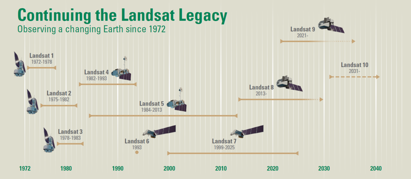
Landsat 10 is the next mission in the joint USGS-NASA Landsat program. Landsat 10 is expected to launch in 2031 and will continue the world’s longest space-based record of Earth’s land surface. Landsat 10 will introduce new imaging capabilities for the next generation of Earth observation.
Landsat 10 is designed to maintain data quality and continuity with earlier Landsat observations, a hallmark of the Landsat Program’s legacy to provide calibrated, open-access, and unbiased Earth observation data to support scientific research and operational monitoring. Landsat 10 will serve the next generation of Landsat data users.
The mission’s “superspectral” instrument suite and finer spatial resolution will support improved monitoring of water quality, agriculture, vegetation health, snow and ice, soil conditions, and other environmental parameters. These advances will enable users to detect, differentiate, and monitor environmental change with greater detail and precision than previous Landsat missions.
Quick Facts | |
| Temporal revisit: 18 days | Spectral bands: 26 (21 visible to shortwave infrared spectral bands (VSWIR); 5 Thermal Infrared (TIR)) |
| Orbit: Sun-synchronous at 653 km (406 miles) | Spatial resolution: 10-20 meters VSWIR; 60 meters atmospheric VSWIR/TIR |
| Orbital inclination: ~98 degrees | Global reference grid system: WRS-3 with 265 orbital paths |
| Equatorial crossing time: 10:10 am ± 5 minutes | Scene size: 164 km (102 miles) x 168 km (104 miles) |
| Mission design life: 5 years | Field of view: ±7.2 degrees from nadir |
| Expected launch date: 2031 | |
Mission Objectives
Under the Sustainable Land Imaging (SLI) Program, Landsat 10 will continue the long-running partnership between the USGS and NASA by acquiring high-quality, medium-resolution, global land imaging data. The mission has four major objectives:
- Collect and archive medium-resolution (10-60m), reflective and emissive superspectral image data affording seasonal coverage of the global land mass for a period of no less than five years
- Ensure data are sufficiently consistent with data from earlier Landsat missions in terms of spectral and spatial characteristics, acquisition rates, geometry, calibration, product quality, and data availability
- Support critical emerging user needs and applications, as characterized by periodic user assessments and identified by operational requirements
- Distribute data products to the public in a timely and dependable manner on a nondiscriminatory, unrestricted basis
These objectives continue Landsat’s more than five-decade legacy of collecting consistent, calibrated data of the Earth’s surface.
Landsat 10’s New Capabilities
Landsat 10 will expand the Landsat program’s ability to monitor Earth’s changing surface by combining finer spatial resolution with new, improved spectral information. These capabilities will support both emerging areas of Earth system science as well as long-standing Landsat applications.
The mission’s 26-band superspectral Landsat Instrument Suite (LandIS) will improve scientists’ ability to detect, characterize, and monitor environmental conditions and change across a wide range of ecosystems and landscapes. Expanded capabilities will support applications including:
- Water quality and aquatic ecosystem monitoring, including harmful algal bloom detection
- Agriculture and soil conservation, including crop residue and non-photosynthetic vegetation mapping
- Forest monitoring and ecosystem assessment
- Snow hydrology and ice dynamics, including snow grain size, liquid water content, and albedo characterization
- Thermal infrared emissivity measurements for geology and mineral mapping
Landsat 10's new measurements and improved details will support scientific research, operational monitoring, and resource management.
Superspectral Observations
Landsat 10 will acquire 26 spectral bands, increasing from the 11 bands collected by Landsat 8 and Landsat 9. The expanded “superspectral” design builds on Landsat’s long-term heritage measurements while providing greater spectral discrimination
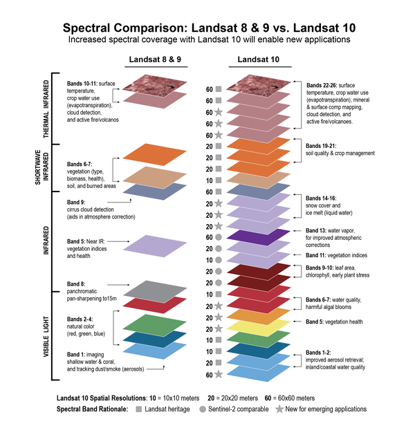
Landsat 10's unified LandIS payload will expand spectral sampling to measure the following:
- 10 new spectral bands will support emerging applications such as harmful algal bloom detection, snow hydrology and ice dynamics, crop residue mapping, and vegetation health and stress
- Two new aerosol and water vapor retrieval spectral bands to improve and autonomously correct for atmospheric effects
- Five Sentinel-2 current generation complementary spectral bands for observational synergy
- 11 refined, heritage Landsat spectral bands
- Five thermal infrared spectral bands to support improved surface temperature and emissivity retrieval, snow grain size, and mineral characterization applications
Landsat sensors have continuously expanded their spectral capabilities as technology has advanced over the last five decades. Landsat 1 acquired four spectral bands, while Landsat 8 and Landsat 9 each collect 11 bands using the Operational Land Imager (OLI) sensor and the Thermal Infrared Sensor (TIRS). Landsat 10 continues that evolution by combining long-term data continuity with expanded spectral observations designed for modern science needs.
As with previous Landsat missions, the spectral bands were selected with input from the user community and positioned within atmospheric windows to minimize atmospheric absorption.
Landsat 10 will acquire all VSWIR and TIR spectral bands nearly simultaneously, minimizing time-dependent solar illumination differences. For example, this sensing feature of LandIS will improve atmospheric cloud detection and screening and will support geophysical surface reflectance and temperature required for retrieval of evapotranspiration information.
View Bandpass Wavelengths for all Landsat Sensors
Finer Spatial Resolution
Landsat 10 and its LandIS payload will collect imagery at finer spatial resolutions than previous Landsat missions. Visible, near-infrared, and shortwave-infrared observations will be acquired at 10- to 20-meter resolution, while atmospheric visible-to-shortwave infrared (VSWIR) and thermal infrared observations will be acquired at 60-meter resolution.
Spatial resolution refers to the size of the ground area represented in each image pixel. Finer spatial resolution allows scientists and resource managers to observe smaller features and detect environmental changes in greater detail.
Landsat 10 will collect:
- 10-meter ground sample distance (GSD) for five foundational spectral bands; Blue, Green, Red2, NIR Broad and SWIR to support more detailed spectral index calculations
- 20-meter GSD for additional visible to shortwave infrared (VSWIR)
- 60-meter GSD for atmospheric VSWIR and thermal infrared (TIR)
Finer spatial resolution improves the ability to characterize environmental conditions and change across varied landscapes, including urban areas, coastal ecosystems, forests, and agricultural regions. The enhanced resolution will also improve detection and mapping of smaller surface features such as streams, riparian corridors, woodlots, and individual agricultural fields.
The improved spatial resolution was informed by a user needs survey and is designed to better harmonize Landsat observations with Sentinel-2 current generation data for integrated analysis and data fusion.
Robust Radiometric and Geometric Performance
The Landsat Program serves as the gold standard for global land imaging because it provides highly calibrated Earth observation data. Maintaining that scientifically consistent Earth observation record across multiple decades and missions requires rigorous calibration practices and long-term data stewardship.
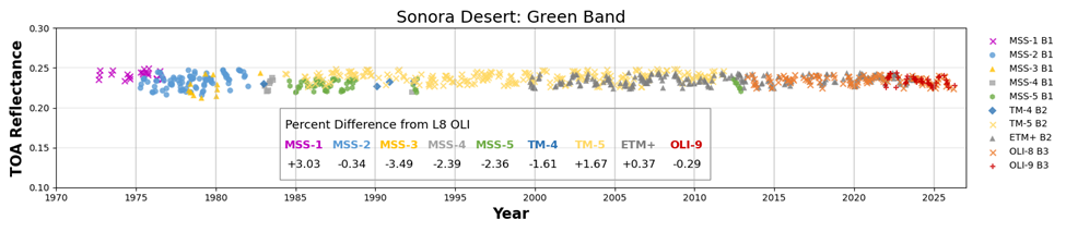
Landsat 10 will continue the program’s precise approach to calibration and validation accuracy. Radiometric performance requirements are designed to maintain continuity with Landsat 8 and Landsat 9’s heritage bands, while geometric performance requirements have been updated to support Landsat 10’s finer spatial resolutions.
The radiometric requirements for Landsat 10 include:
- Signal-to-noise ratios (SNR) matching Landsat 9 when aggregated to 30-meter pixels
- Less than 5% absolute error in at-sensor radiance and less than 3% in reflectance
- TIR absolute radiometric accuracy within 1% at normal Earth temperatures
The geometric requirements for Landsat 10 include:
- Sub-pixel band-to-band registration accuracy to support multispectral analysis
- Less than 8-meter geolocation error for most observations after ground-based geometric correction and terrain compensation
LandIS will acquire all bands for a scene within a 15-second period to support multispectral analysis. Band-to-band co-registration will be 2, 3, and 6 meters for the 10-, 20-, and 60-meter solar reflective bands, respectively, and 15 meters between the reflective and thermal infrared bands.
Landsat’s consistent and high-quality measurements have enabled long-term environmental monitoring, quantitative scientific analysis, and higher-level science products. Its rigorous calibration standards have also positioned Landsat as a trusted “gold standard” reference for commercial and international satellite missions and Earth observation data products worldwide.
Worldwide Reference System 3 (WRS-3)
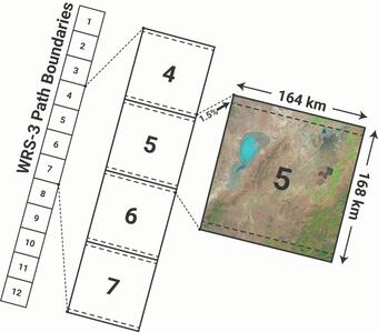
Landsat 10 will use a new global reference grid system called the Worldwide Reference System-3 (WRS-3) to acquire, catalog, and distribute imagery. The updated system was developed to support Landsat 10’s lower orbital altitude and revised ground track geometry.
Key features of WRS-3 include:
- 10:10 a.m. equatorial crossing time (±5 minutes)
- 265 orbital paths in WRS-3, compared to 233 in WRS-2
- Approximately 151 km (94 mi) spacing between adjacent ground tracks at the equator
- Scene size: 164 km × 168 km (102 mi x 104 mi).
Landsat 10 will operate in a sun-synchronous orbit at an altitude of 653 kilometers (406 miles) with an orbital inclination of approximately 98 degrees. The observatory will cross the equator at approximately 10:10 am mean local time on descending daytime passes.
The system is designed to support systematic global survey imaging while maintaining compatibility with modern pixel-based analysis and long-term Landsat data continuity.
Data Volume, Storage, and Computing
Landsat 10’s expanded spectral and spatial capabilities will significantly increase the volume of data collected and processed by the USGS ground segment. The observatory is expected to acquire approximately 900 scenes per day.
The mission’s expanded spectral coverage and finer spatial resolution will increase overall data volumes, with Level-1 data products generated from these observations estimated to be approximately 3.7 gigabytes per scene.
In total, Landsat 10 is expected to add approximately 3.3 terabytes of data to the Landsat archive daily. The growing data volumes will continue to drive advances in cloud-based storage, processing, and large-scale Earth observation analysis.
Why Landsat 10 Matters
For more than five decades, the Landsat Program has provided a continuous, rigorously calibrated, open-access, and unbiased record of the Earth’s land surface, enabling scientists, resource managers, and decision makers around the world to monitor environmental change over time. Landsat 10 will continue that record while expanding the satellite program’s ability to observe Earth in greater spatial and spectral detail.
These capabilities will support a broad range of terrestrial land, water, and Earth system science applications. Harmonization with other Earth observation systems, advances in cloud computing, and evolving analytical approaches will further expand the ways Landsat data are used for scientific research and operational applications.
By combining long-term continuity with new observations and improved measurements, Landsat 10 will continue the “gold standard” and support the next generation of Earth system science while providing critical information for understanding and managing a changing planet.
References:
Landsat 10 mission concept planning its science requirements were informed by user community assessments, the Landsat Science Team, advisory reports, and user feedback that are summarized in part in the following resources:
- User Needs for Future Landsat Missions (Wu et al., 2019)
- Recommendations for Possible Future U.S. Global Land Data Collection Missions Beyond Landsat 9 (Landsat Advisory Group, 2018)
- Landsat and Beyond (National Research Council, 2013)
- Recommendations from the 2018-2023 Landsat Science Team
- Feedback from the Landsat 10 Request for Information (SAM.gov Notice ID: RFI2020lLandsat10)