
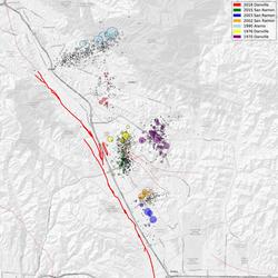
Just as the Bartlett Springs and Maacama faults are the major bounding faults of the Clear Lake volcanic field, the Collayami (purple) and Maacama (green) faults bound the Geysers Geothermal Field.
Why are there so many earthquakes in the Geysers area in Northern California?
The Geysers Geothermal Field is located in a tectonically active region of Northern California. The major seismic hazards in the region are from large earthquakes occurring along regional faults that are located miles away from the geothermal field, such as the San Andreas and Healdsburg-Rodgers Creek faults. However, activities associated with the withdrawal of steam for producing electric power cause or induce small quakes to occur in the field. These smaller quakes are frequently felt by those who work at the field and by nearby residents.
Seismicity at The Geysers was poorly documented when power generation commenced in the 1960's, but since 1975 high-quality seismic monitoring data has been available, and it has been demonstrated that increased steam production and fluid injection correlates positively with changes in earthquake activity. The level of seismicity has been fairly stable since the mid-1980s, even though power production has declined in the field with the depletion of the steam reservoirs. Sheet 3 of Seismicity map of Santa Rosa, California 1969-1995 illustrates how seismicity has spatially and temporally expanded with geothermal production.
Seismologists have proposed several mechanisms to explain why earthquakes are being induced. The operators of the geothermal field are withdrawing mass (steam boiled from water) and heat, both of which cause the surrounding rock to contract, which in turn can induce earthquakes as a result of the contractional stresses. In addition, the operators condense the extracted steam and flow the water back into the steam reservoir at depths of one to three km in order to extend the life of the field. Furthermore, reclaimed water from nearby Lake County and Santa Rosa is pumped to The Geysers and flowed into the steam reservoir. The condensed steam and reclaimed water is cold, whereas the rock is hot, and it appears that this thermal contrast is a significant factor in inducing the earthquakes. It is also possible that the hydraulic pressure of the injected fluid finds its way into faults and facilitates fracturing due to increased fluid pressures.
To date, the largest quake recorded at The Geysers is approximately M4.5. It is possible that a magnitude 5 could occur, but larger earthquakes are thought to be unlikely. In order for a larger earthquake to occur, it is necessary that a large fault exist. For example, the 1906 magnitude (M) 7.8 San Francisco earthquake ruptured nearly 300 miles of the San Andreas Fault. At The Geysers no such continuous fault is known to exist. Rather, there are numerous small fractures in the rock located near the many steam and injection wells. The activities described above result in local stress changes which, when added to the prevailing regional tectonic stresses, induce the quakes on these small faults.
Studies were conducted in the 1980's to image the magma body using seismic data from distant earthquakes and other geophysical data. These studies have limited resolution, and some of the interpretations are controversial. The magma body, if correctly modeled, is mostly in the Earth's crust. It is thought that basaltic intrusions have intruded the crust, melting the host rock and forming a silicic magma chamber more than 7 km below the earth's surface. Steam wells have encountered granitic material at depths of 1 to 4 km, and at the surface volcanic rocks form Cobb Mountain on the eastern edge of the field. However, all these igneous rocks have been dated at over 1 million years old, and are therefore too old to be the heat source for the active geothermal system at The Geysers. Volcanic rocks as young as 10,000 years are found further north in the Clear Lake region, and scientists believe that similarly young intrusive rocks underlie The Geysers as well, but much deeper than the deepest steam wells. All of the earthquakes at The Geysers locate at depths above 6 km and above the presumed magma body.
At this time, there is no evidence that magmatic pressures are involved in generating earthquakes. Our main methods for detecting volcanic unrest are seismic and geodetic. The Geysers field is densely monitored by seismic instrumentation operated by both Calpine Corporation and the USGS, and both data streams are integrated in real time into the latest earthquakes map. The seismic instrumentation would record signs of volcanic unrest such as harmonic tremor or long-period quakes, and scientists would quickly recognize any deepening of quakes. The USGS, UC Berkeley, and the NSF Plate Boundary Observatory also operate regional GPS networks that could be densified should the situation warrant.
Related

What is an earthquake and what causes them to happen? What is an earthquake and what causes them to happen?
An earthquake is caused by a sudden slip on a fault. The tectonic plates are always slowly moving, but they get stuck at their edges due to friction. When the stress on the edge overcomes the friction, there is an earthquake that releases energy in waves that travel through the earth's crust and cause the shaking that we feel. In California there are two plates - the Pacific Plate and the North...
Foreshocks, aftershocks - what's the difference? Foreshocks, aftershocks - what's the difference?
"Foreshock" and "aftershock" are relative terms. Foreshocks are earthquakes that precede larger earthquakes in the same location. An earthquake cannot be identified as a foreshock until after a larger earthquake in the same area occurs. Aftershocks are smaller earthquakes that occur in the same general area during the days to years following a larger event or "mainshock." They occur within 1-2...

Can the position of the moon or the planets affect seismicity? Are there more earthquakes in the morning/in the evening/at a certain time of the month? Can the position of the moon or the planets affect seismicity? Are there more earthquakes in the morning/in the evening/at a certain time of the month?
Earthquakes are equally as likely to occur in the morning or the evening. Many studies in the past have shown no significant correlations between the rate of earthquake occurrence and the semi-diurnal tides when using large earthquake catalogs. Several recent studies, however, have found a correlation between earth tides (caused by the position of the moon relative to the earth) and some types of...
What is surface faulting or surface rupture in an earthquake? What is surface faulting or surface rupture in an earthquake?
Surface rupture occurs when movement on a fault deep within the earth breaks through to the surface. NOT ALL earthquakes result in surface rupture.

At what depth do earthquakes occur? What is the significance of the depth? At what depth do earthquakes occur? What is the significance of the depth?
Earthquakes occur in the crust or upper mantle, which ranges from the earth's surface to about 800 kilometers deep (about 500 miles). The strength of shaking from an earthquake diminishes with increasing distance from the earthquake's source, so the strength of shaking at the surface from an earthquake that occurs at 500 km deep is considerably less than if the same earthquake had occurred at 20...

Do earthquakes occur in Antarctica? Do earthquakes occur in Antarctica?
Earthquakes do occur in Antarctica, but not very often. There have been some big earthquakes--including one magnitude 8.1--in the Balleny Islands (between Antarctica and New Zealand). The boundary between the Scotia Plate and the Antarctic Plate just grazes the north tip of the Antarctic Peninsula (look "northwest" from the Pole toward South America). There is also a hint of a line of seismicity...
Where can I find earthquake educational materials? Where can I find earthquake educational materials?
Start with our Earthquake Hazards Education site. That includes: Earthquakes for Kids Cool Earthquake Facts Earthquake Science for Everyone Other good starting points include: State Geological Surveys for states in earthquake-prone regions The Great ShakeOut Earthquake Drills website SAGE (Seismological Facility for the Advancement of Geoscience), which is a non-profit consortium
Can we cause earthquakes? Is there any way to prevent earthquakes? Can we cause earthquakes? Is there any way to prevent earthquakes?
Earthquakes induced by human activity have been documented at many locations in the United States and in many other countries around the world. Earthquakes can be induced by a wide range of causes including impoundment of reservoirs, surface and underground mining, withdrawal of fluids and gas from the subsurface, and injection of fluids into underground formations. While most induced earthquakes...
What is the difference between aftershocks and swarms? What is the difference between aftershocks and swarms?
Aftershocks are a sequence of earthquakes that happen after a larger mainshock on a fault. Aftershocks occur near the fault zone where the mainshock rupture occurred and are part of the "readjustment process” after the main slip on the fault. Aftershocks become less frequent with time, although they can continue for days, weeks, months, or even years for a very large mainshock. A swarm, on the...

Faults bounding the Geysers Geothermal Complex
Just as the Bartlett Springs and Maacama faults are the major bounding faults of the Clear Lake volcanic field, the Collayami (purple) and Maacama (green) faults bound the Geysers Geothermal Field.
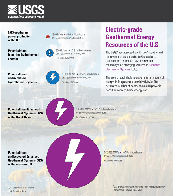
Electric-grade geothermal energy resources of the U.S.
Electric-grade geothermal energy resources of the U.S.Infographic of Electric-grade geothermal energy resources of the U.S.
The USGS has assessed the Nation’s geothermal energy resources since the 1970s, updating assessments to include advancements in technology. An emerging resource is Enhanced Geothermal Systems (EGS).
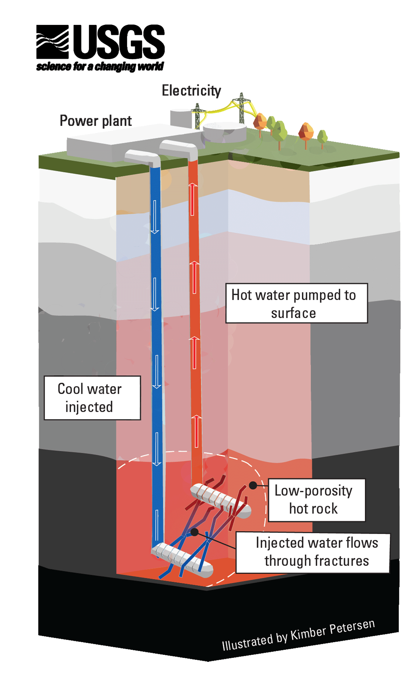
Enhanced Geothermal Systems (Illustrated GIF)
Enhanced Geothermal Systems are an emerging resource that the USGS studies. To generate electricity from these systems, fractures are engineered into deep, low-porosity hot rocks to allow water to circulate. Then, the heated water is pumped back to the surface, where the thermal energy is used to move a turbine and generate electricity.
Enhanced Geothermal Systems are an emerging resource that the USGS studies. To generate electricity from these systems, fractures are engineered into deep, low-porosity hot rocks to allow water to circulate. Then, the heated water is pumped back to the surface, where the thermal energy is used to move a turbine and generate electricity.

PubTalk-09/2023 - Geothermal Energy Research Within the USGS: Goldilocks to Electricity With Earthquakes in Between
PubTalk-09/2023 - Geothermal Energy Research Within the USGS: Goldilocks to Electricity With Earthquakes in BetweenGeothermal Energy Research Within the USGS: Goldilocks to Electricity With Earthquakes in Between

Geothermal Plant
A geothermal power plant at The Geysers near Santa Rosa, California. The USGS researches and assesses geothermal resources.
A geothermal power plant at The Geysers near Santa Rosa, California. The USGS researches and assesses geothermal resources.

PubTalk 8/2009 — The Future of Geothermal Energy
a discussion of present opportunities and future challenges
by Colin F. Williams, USGS Geophysicist
a discussion of present opportunities and future challenges
by Colin F. Williams, USGS Geophysicist
Related
What is an earthquake and what causes them to happen? What is an earthquake and what causes them to happen?
An earthquake is caused by a sudden slip on a fault. The tectonic plates are always slowly moving, but they get stuck at their edges due to friction. When the stress on the edge overcomes the friction, there is an earthquake that releases energy in waves that travel through the earth's crust and cause the shaking that we feel. In California there are two plates - the Pacific Plate and the North...
Foreshocks, aftershocks - what's the difference? Foreshocks, aftershocks - what's the difference?
"Foreshock" and "aftershock" are relative terms. Foreshocks are earthquakes that precede larger earthquakes in the same location. An earthquake cannot be identified as a foreshock until after a larger earthquake in the same area occurs. Aftershocks are smaller earthquakes that occur in the same general area during the days to years following a larger event or "mainshock." They occur within 1-2...
Can the position of the moon or the planets affect seismicity? Are there more earthquakes in the morning/in the evening/at a certain time of the month? Can the position of the moon or the planets affect seismicity? Are there more earthquakes in the morning/in the evening/at a certain time of the month?
Earthquakes are equally as likely to occur in the morning or the evening. Many studies in the past have shown no significant correlations between the rate of earthquake occurrence and the semi-diurnal tides when using large earthquake catalogs. Several recent studies, however, have found a correlation between earth tides (caused by the position of the moon relative to the earth) and some types of...
What is surface faulting or surface rupture in an earthquake? What is surface faulting or surface rupture in an earthquake?
Surface rupture occurs when movement on a fault deep within the earth breaks through to the surface. NOT ALL earthquakes result in surface rupture.
At what depth do earthquakes occur? What is the significance of the depth? At what depth do earthquakes occur? What is the significance of the depth?
Earthquakes occur in the crust or upper mantle, which ranges from the earth's surface to about 800 kilometers deep (about 500 miles). The strength of shaking from an earthquake diminishes with increasing distance from the earthquake's source, so the strength of shaking at the surface from an earthquake that occurs at 500 km deep is considerably less than if the same earthquake had occurred at 20...
Do earthquakes occur in Antarctica? Do earthquakes occur in Antarctica?
Earthquakes do occur in Antarctica, but not very often. There have been some big earthquakes--including one magnitude 8.1--in the Balleny Islands (between Antarctica and New Zealand). The boundary between the Scotia Plate and the Antarctic Plate just grazes the north tip of the Antarctic Peninsula (look "northwest" from the Pole toward South America). There is also a hint of a line of seismicity...
Where can I find earthquake educational materials? Where can I find earthquake educational materials?
Start with our Earthquake Hazards Education site. That includes: Earthquakes for Kids Cool Earthquake Facts Earthquake Science for Everyone Other good starting points include: State Geological Surveys for states in earthquake-prone regions The Great ShakeOut Earthquake Drills website SAGE (Seismological Facility for the Advancement of Geoscience), which is a non-profit consortium
Can we cause earthquakes? Is there any way to prevent earthquakes? Can we cause earthquakes? Is there any way to prevent earthquakes?
Earthquakes induced by human activity have been documented at many locations in the United States and in many other countries around the world. Earthquakes can be induced by a wide range of causes including impoundment of reservoirs, surface and underground mining, withdrawal of fluids and gas from the subsurface, and injection of fluids into underground formations. While most induced earthquakes...
What is the difference between aftershocks and swarms? What is the difference between aftershocks and swarms?
Aftershocks are a sequence of earthquakes that happen after a larger mainshock on a fault. Aftershocks occur near the fault zone where the mainshock rupture occurred and are part of the "readjustment process” after the main slip on the fault. Aftershocks become less frequent with time, although they can continue for days, weeks, months, or even years for a very large mainshock. A swarm, on the...
Faults bounding the Geysers Geothermal Complex
Just as the Bartlett Springs and Maacama faults are the major bounding faults of the Clear Lake volcanic field, the Collayami (purple) and Maacama (green) faults bound the Geysers Geothermal Field.
Just as the Bartlett Springs and Maacama faults are the major bounding faults of the Clear Lake volcanic field, the Collayami (purple) and Maacama (green) faults bound the Geysers Geothermal Field.
Electric-grade geothermal energy resources of the U.S.
Electric-grade geothermal energy resources of the U.S.Infographic of Electric-grade geothermal energy resources of the U.S.
The USGS has assessed the Nation’s geothermal energy resources since the 1970s, updating assessments to include advancements in technology. An emerging resource is Enhanced Geothermal Systems (EGS).
Enhanced Geothermal Systems (Illustrated GIF)
Enhanced Geothermal Systems are an emerging resource that the USGS studies. To generate electricity from these systems, fractures are engineered into deep, low-porosity hot rocks to allow water to circulate. Then, the heated water is pumped back to the surface, where the thermal energy is used to move a turbine and generate electricity.
Enhanced Geothermal Systems are an emerging resource that the USGS studies. To generate electricity from these systems, fractures are engineered into deep, low-porosity hot rocks to allow water to circulate. Then, the heated water is pumped back to the surface, where the thermal energy is used to move a turbine and generate electricity.
PubTalk-09/2023 - Geothermal Energy Research Within the USGS: Goldilocks to Electricity With Earthquakes in Between
PubTalk-09/2023 - Geothermal Energy Research Within the USGS: Goldilocks to Electricity With Earthquakes in BetweenGeothermal Energy Research Within the USGS: Goldilocks to Electricity With Earthquakes in Between
Geothermal Plant
A geothermal power plant at The Geysers near Santa Rosa, California. The USGS researches and assesses geothermal resources.
A geothermal power plant at The Geysers near Santa Rosa, California. The USGS researches and assesses geothermal resources.
PubTalk 8/2009 — The Future of Geothermal Energy
a discussion of present opportunities and future challenges
by Colin F. Williams, USGS Geophysicist
a discussion of present opportunities and future challenges
by Colin F. Williams, USGS Geophysicist
Updated Date: August 14, 2025