
This map of the United States and its territories shows geographic extent of the first-ever nationally consistent hydrography data acquired from high-resolution 3D Elevation Program (3DEP) data. FY26 projects are the result of ongoing Federal coordination via the 3DHP Working Group and the Alaska Mapping Initiative.
Multimedia
3D Hydrography Program Multimedia are available below
Images
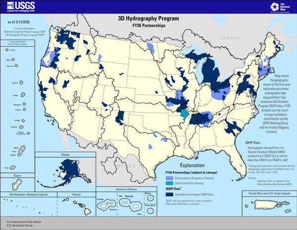
3D Hydrography Program FY26 Partnerships
This map of the United States and its territories shows geographic extent of the first-ever nationally consistent hydrography data acquired from high-resolution 3D Elevation Program (3DEP) data. FY26 projects are the result of ongoing Federal coordination via the 3DHP Working Group and the Alaska Mapping Initiative.

3D Hydrography Program FY26 Partnerships in Alaska
3D Hydrography Program FY26 Partnerships in AlaskaThis map of Alaska shows geographic extent of the first-ever nationally consistent hydrography data acquired from high-resolution 3D Elevation Program (3DEP) data. FY26 projects are the result of ongoing Federal coordination via the 3DHP Working Group and the Alaska Mapping Initiative.
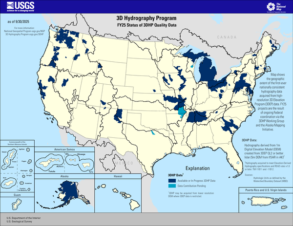
FY25 Status of 3DHP Quality Data
This map of the United States and its territories shows geographic extent of the first-ever nationally consistent hydrography data acquired from high-resolution 3D Elevation Program (3DEP) data. FY25 projects are the result of ongoing Federal coordination via the 3DHP Working Group and the Alaska Mapping Initiative.
This map of the United States and its territories shows geographic extent of the first-ever nationally consistent hydrography data acquired from high-resolution 3D Elevation Program (3DEP) data. FY25 projects are the result of ongoing Federal coordination via the 3DHP Working Group and the Alaska Mapping Initiative.
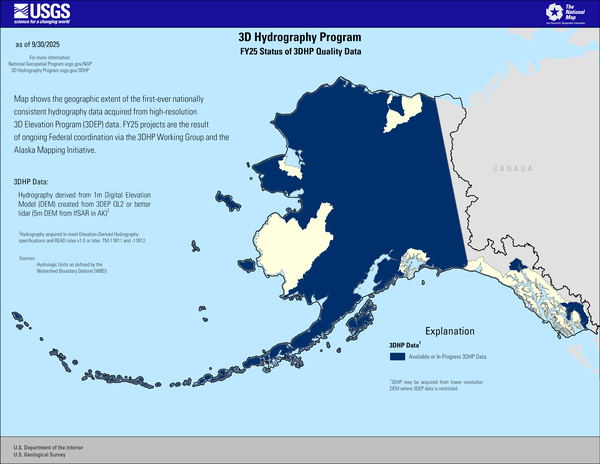
FY25 Status of 3DHP Quality Data in Alaska
This map of Alaska shows geographic extent of the first-ever nationally consistent hydrography data acquired from high-resolution 3D Elevation Program (3DEP) data. FY25 projects are the result of ongoing Federal coordination via the 3DHP Working Group and the Alaska Mapping Initiative.
Explanation
This map of Alaska shows geographic extent of the first-ever nationally consistent hydrography data acquired from high-resolution 3D Elevation Program (3DEP) data. FY25 projects are the result of ongoing Federal coordination via the 3DHP Working Group and the Alaska Mapping Initiative.
Explanation
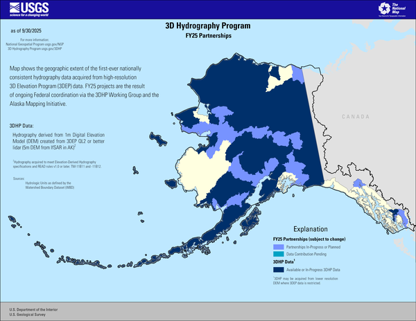
3D Hydrography Program FY25 Partnerships in Alaska
3D Hydrography Program FY25 Partnerships in AlaskaThis map of Alaska shows geographic extent of the first-ever nationally consistent hydrography data acquired from high-resolution 3D Elevation Program (3DEP) data. FY25 projects are the result of ongoing Federal coordination via the 3DHP Working Group and the Alaska Mapping Initiative.
Explanation
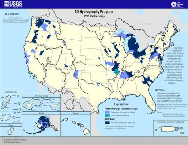
3D Hydrography Program FY25 Partnerships
This map of the United States and its territories shows geographic extent of the first-ever nationally consistent hydrography data acquired from high-resolution 3D Elevation Program (3DEP) data. FY25 projects are the result of ongoing Federal coordination via the 3DHP Working Group and the Alaska Mapping Initiative.
This map of the United States and its territories shows geographic extent of the first-ever nationally consistent hydrography data acquired from high-resolution 3D Elevation Program (3DEP) data. FY25 projects are the result of ongoing Federal coordination via the 3DHP Working Group and the Alaska Mapping Initiative.
Videos

January 27, 2026 USGS Hydrography Community Call: Enriching your enterprise hydrography layers with data: Washington State
January 27, 2026 USGS Hydrography Community Call: Enriching your enterprise hydrography layers with data: Washington StateOur presenter will be Josh Greenberg, the Washington Hydrography Data Steward (WASHD).

December 16, 2025 USGS Hydrography Community Call
The topic will be “3DHP Overview and Status – FY25 Accomplishments and FY26 Plans”
Presenter is Steve Aichele, National Geospatial Program Hydrography Planning and Management Lead
The topic will be “3DHP Overview and Status – FY25 Accomplishments and FY26 Plans”
Presenter is Steve Aichele, National Geospatial Program Hydrography Planning and Management Lead

July 22, 2025 USGS Hydrography Community Call
Steve Aichele, the National Geospatial Program Hydrography Management and Planning Lead, announced publication of the Holston River, TN hydrologic unit 10 (0601010403) in the 3D Hydrography Program web map services and provided update on HydroAdd planned release of the Beta version (August 2025) and version 1.0 (September 2025).
Steve Aichele, the National Geospatial Program Hydrography Management and Planning Lead, announced publication of the Holston River, TN hydrologic unit 10 (0601010403) in the 3D Hydrography Program web map services and provided update on HydroAdd planned release of the Beta version (August 2025) and version 1.0 (September 2025).

April 22, 2025 USGS Hydrography Community Call: 3D Hydrography Program Announcements and "Updating historical flow permanence classifications with probabilistic continuous-value estimates” Presentation
April 22, 2025 USGS Hydrography Community Call: 3D Hydrography Program Announcements and "Updating historical flow permanence classifications with probabilistic continuous-value estimates” PresentationSteve Aichele, the National Geospatial Program Hydrography Management and Planning Lead, announced release of the Elevation Derived Hydrography Specification 2024 Revision A3 and updates on the following:
April 22, 2025 USGS Hydrography Community Call: 3D Hydrography Program Announcements and "Updating historical flow permanence classifications with probabilistic continuous-value estimates” Presentation
April 22, 2025 USGS Hydrography Community Call: 3D Hydrography Program Announcements and "Updating historical flow permanence classifications with probabilistic continuous-value estimates” PresentationApril 22, 2025 USGS Hydrography Community Call: 3D Hydrography Program Announcements and "Updating historical flow permanence classifications with probabilistic continuous-value estimates” Presentation
April 22, 2025 USGS Hydrography Community Call: 3D Hydrography Program Announcements and "Updating historical flow permanence classifications with probabilistic continuous-value estimates” PresentationSteve Aichele, the National Geospatial Program Hydrography Management and Planning Lead, announced release of the Elevation Derived Hydrography Specification 2024 Revision A3 and updates on the following:

January 28, 2025 USGS Hydrography Community Call: 3D Hydrography Program Announcements and “HydroAdd3D Sneak Peak”
January 28, 2025 USGS Hydrography Community Call: 3D Hydrography Program Announcements and “HydroAdd3D Sneak Peak”Steve Aichele, the National Geospatial Program Hydrography Management and Planning Lead, announced release of updated Elevation Derived Hydrography Specifications and publication of the following products and services:
 Data")
December 2024 USGS Hydrography Community Call: Delivering and Using 3D Hydrography Program (3DHP) Data
December 2024 USGS Hydrography Community Call: Delivering and Using 3D Hydrography Program (3DHP) DataThe 3D Hydrography Program (3DHP) database will initially be populated with the National Hydrography Dataset (NHD) features, mapped to the new data model. The NHD-source features will be replaced with hydrography derived from the 3D Elevation Program (3DEP) lidar and IfSAR data as it becomes available.