U.S. flag

An official website of the United States government

Multimedia

3D Hydrography Program Multimedia are available below

Images

Noatak River Alaska 3DHP Service

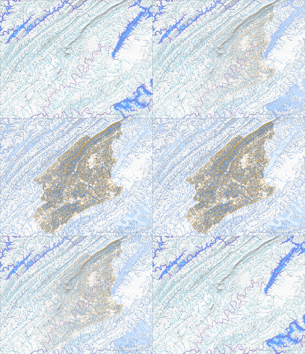
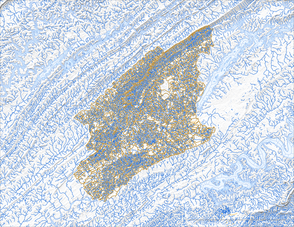
Image of 3DHP data along the Noatak River in Alaska, showing flowlines, waterbodies, and catchments

Image of 3DHP data along the Noatak River in Alaska, showing flowlines, waterbodies, and catchments

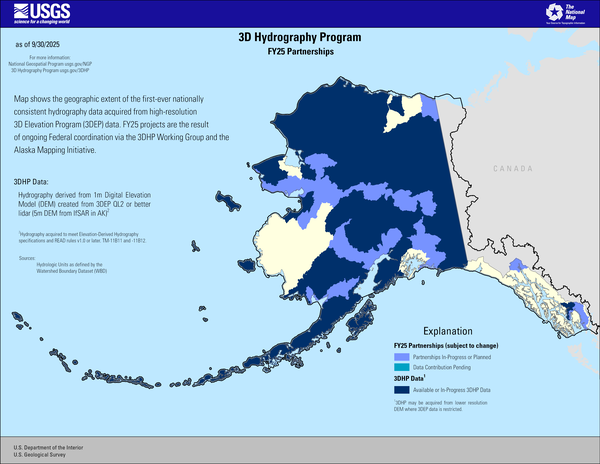
3D Hydrography Program FY24 Partnerships in Alaska

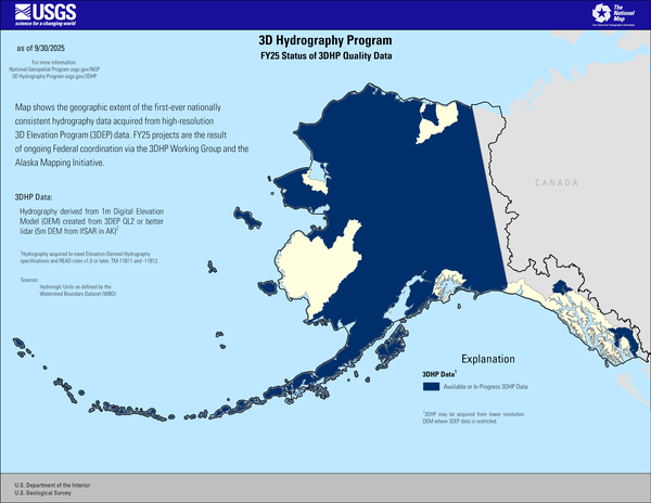
This map of Alaska shows geographic extent of the first-ever nationally consistent hydrography data acquired from high-resolution 3D Elevation Program (3DEP) data. FY24 projects are the result of ongoing Federal coordination via the 3DHP Working Group and the Alaska Mapping Initiative.


Explanation


FY24 Status of 3DHP Quality Data in Alaska

This map of Alaska shows geographic extent of the first-ever nationally consistent hydrography data acquired from high-resolution 3D Elevation Program (3DEP) data. FY24 projects are the result of ongoing Federal coordination via the 3DHP Working Group and the Alaska Mapping Initiative.


Explanation
 

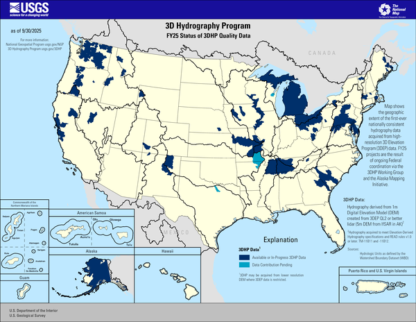
FY24 Status of 3DHP Quality Data

This map of the United States and its territories shows geographic extent of the first-ever nationally consistent hydrography data acquired from high-resolution 3D Elevation Program (3DEP) data. FY24 projects are the result of ongoing Federal coordination via the 3DHP Working Group and the Alaska Mapping Initiative.


This map of the United States and its territories shows geographic extent of the first-ever nationally consistent hydrography data acquired from high-resolution 3D Elevation Program (3DEP) data. FY24 projects are the result of ongoing Federal coordination via the 3DHP Working Group and the Alaska Mapping Initiative.


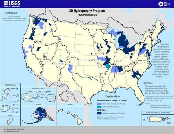
3D Hydrography Program FY24 Partnerships

This map of the United States and its territories shows geographic extent of the first-ever nationally consistent hydrography data acquired from high-resolution 3D Elevation Program (3DEP) data. FY24 projects are the result of ongoing Federal coordination via the 3DHP Working Group and the Alaska Mapping Initiative.


This map of the United States and its territories shows geographic extent of the first-ever nationally consistent hydrography data acquired from high-resolution 3D Elevation Program (3DEP) data. FY24 projects are the result of ongoing Federal coordination via the 3DHP Working Group and the Alaska Mapping Initiative.


3DHP Map FY24 Partnerships and DCA Projects

This map of the United States and its territories shows geographic extent of the first-ever nationally consistent hydrography data acquired from high-resolution 3D Elevation Program (3DEP) data.

This map of the United States and its territories shows geographic extent of the first-ever nationally consistent hydrography data acquired from high-resolution 3D Elevation Program (3DEP) data.

Videos

January 28 2025 Hydrography Community Call Thumbnail January 28, 2025 USGS Hydrography Community Call: 3D Hydrography Program Announcements and “HydroAdd3D Sneak Peak”
January 28, 2025 USGS Hydrography Community Call: 3D Hydrography Program Announcements and “HydroAdd3D Sneak Peak”

Steve Aichele, the National Geospatial Program Hydrography Management and Planning Lead, announced release of updated Elevation Derived Hydrography Specifications and publication of the following products and services: 

Steve Aichele, the National Geospatial Program Hydrography Management and Planning Lead, announced release of updated Elevation Derived Hydrography Specifications and publication of the following products and services: 

December 2024 USGS Hydrography Community Call: Delivering and Using 3D Hydrography Program (3DHP) Data Thumbnail December 2024 USGS Hydrography Community Call: Delivering and Using 3D Hydrography Program (3DHP) Data
December 2024 USGS Hydrography Community Call: Delivering and Using 3D Hydrography Program (3DHP) Data

The 3D Hydrography Program (3DHP) database will initially be populated with the National Hydrography Dataset (NHD) features, mapped to the new data model. The NHD-source features will be replaced with hydrography derived from the 3D Elevation Program (3DEP) lidar and IfSAR data as it becomes available.

The 3D Hydrography Program (3DHP) database will initially be populated with the National Hydrography Dataset (NHD) features, mapped to the new data model. The NHD-source features will be replaced with hydrography derived from the 3D Elevation Program (3DEP) lidar and IfSAR data as it becomes available.

The 3D Hydrography Program at one year – what was accomplished in FY24, what is planned for FY25? thumbnail The 3D Hydrography Program at one year – what was accomplished in FY24, what is planned for FY25?
The 3D Hydrography Program at one year – what was accomplished in FY24, what is planned for FY25?

Federal Fiscal Year 2024 was the first full operational year for the 3D Hydrography Program. We made significant progress in a number of areas, publishing final versions of legacy products, and developing processes for the new program. This presentation will provide an overview of what was accomplished in FY24 and what is planned for FY25. 

Federal Fiscal Year 2024 was the first full operational year for the 3D Hydrography Program. We made significant progress in a number of areas, publishing final versions of legacy products, and developing processes for the new program. This presentation will provide an overview of what was accomplished in FY24 and what is planned for FY25. 

USGS-NFHP Webinar - The National Map and the 3D Hydrography Program Thumbnail USGS-NFHP Webinar - The National Map and the 3D Hydrography Program
USGS-NFHP Webinar - The National Map and the 3D Hydrography Program

The USGS-NFHP Webinar on the 3D Hydrography Program (3DHP) and The National Map (TNM) provided a deep dive into the current state and future direction of USGS hydrography and elevation data, focusing on the replacement of legacy datasets with highly accurate, 3D-enabled data.

The USGS-NFHP Webinar on the 3D Hydrography Program (3DHP) and The National Map (TNM) provided a deep dive into the current state and future direction of USGS hydrography and elevation data, focusing on the replacement of legacy datasets with highly accurate, 3D-enabled data.

A Statewide Hydraulic Modeling Tool for Stream Crossing Projects in Massachusetts Thumbnail A Statewide Hydraulic Modeling Tool for Stream Crossing Projects in Massachusetts
A Statewide Hydraulic Modeling Tool for Stream Crossing Projects in Massachusetts

The U.S. Geological Survey and the University of Massachusetts at Amherst (UMass Amherst), in cooperation with the Massachusetts Department of Environmental Protection (MassDEP), began a series of studies in 2019 to develop a web-based statewide hydraulic modeling tool to provide preliminary culvert designs for stream-crossing projects in Massachusetts.

The U.S. Geological Survey and the University of Massachusetts at Amherst (UMass Amherst), in cooperation with the Massachusetts Department of Environmental Protection (MassDEP), began a series of studies in 2019 to develop a web-based statewide hydraulic modeling tool to provide preliminary culvert designs for stream-crossing projects in Massachusetts.

Understanding the Transition from NHDPlus HR to 3DHP Thumbnail Understanding the Transition from NHDPlus HR to 3DHP
Understanding the Transition from NHDPlus HR to 3DHP

The new 3D Hydrography Program (3DHP) is the focus of USGS efforts to acquire and produce detailed surface-water mapping information, such as lakes, ponds, rivers and streams.

The new 3D Hydrography Program (3DHP) is the focus of USGS efforts to acquire and produce detailed surface-water mapping information, such as lakes, ponds, rivers and streams.

Was this page helpful?