
Mapping wild horse densities across broad landscapes of the Western United States
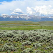
Researchers at USGS are using historical wild horse survey and monitoring records to conduct a study of horse density across sagebrush ecosystems of the western United States. Researchers will develop generalized density maps for the species that will enhance concurrent evaluations into the ecological effects of wild horse populations.
Background
Since the early 2000s, wild horse populations have increased across western rangelands, largely exceeding the ecological capacity of lands they inhabit. Wild horses can alter or degrade ecosystem processes, facilitate invasive plant establishment, and reduce food and water availability to other wildlife. As the primary agency responsible for wild horse management on U.S. public lands, the Bureau of Land Management (BLM) has a need to characterize the density and distribution of free-roaming horses across their range, especially across imperiled sagebrush ecosystems. Surveying wild horse populations within and around BLM Herd Areas (HA) and Herd Management Areas (HMA) is challenging due to the large spatial extents, differences in vegetation and topography, and permeable fence lines along management area boundaries. Annual counts of herds can provide an index of relative density, but horses are highly mobile, and environmental factors like food and water can vary over space and time, affecting horse movement and distribution on the landscape. In turn, these factors influence horse reproduction and survival as well as the potential risk of negative horse density effects to vegetation and other wildlife. However, recent advancements in spatial modeling approaches offer new opportunities to understand and predict horse density and distribution patterns from survey and monitoring records dating back to the 1970’s.
Project goals and anticipated outcomes
We are investigating the spatio-temporal patterns of horse density in and around HAs and HMAs by leveraging 50 years of wild horse survey data with advances in spatial modeling. We will compile and summarize horse survey and remotely sensed environmental data across the sagebrush biome to better understand factors influencing horse density and distribution. From these datasets, we will create spatially explicit maps of wild horse density inside HMAs and predicted density outside HMAs.
This study will produce a time series of generalized horse density estimates across HAs, HMAs, and adjacent western rangeland ecosystems. The results of this work will enhance research evaluating the effects of wild horse populations on vegetation and wildlife as well as open the door to other researchers exploring questions about the ecological effects of wild horses.

Shrubland, Alpine and Grassland Ecology (SAGE) Wildlife Research Group

Greater Sage-Grouse Population Monitoring Framework

Wild horse and livestock influences on vegetation and wildlife in sagebrush ecosystems: Implications for refining and validating Appropriate Management Level (AML)

America's Wild Horses and Burros—Research to Support Management
Researchers at USGS are using historical wild horse survey and monitoring records to conduct a study of horse density across sagebrush ecosystems of the western United States. Researchers will develop generalized density maps for the species that will enhance concurrent evaluations into the ecological effects of wild horse populations.
Background
Since the early 2000s, wild horse populations have increased across western rangelands, largely exceeding the ecological capacity of lands they inhabit. Wild horses can alter or degrade ecosystem processes, facilitate invasive plant establishment, and reduce food and water availability to other wildlife. As the primary agency responsible for wild horse management on U.S. public lands, the Bureau of Land Management (BLM) has a need to characterize the density and distribution of free-roaming horses across their range, especially across imperiled sagebrush ecosystems. Surveying wild horse populations within and around BLM Herd Areas (HA) and Herd Management Areas (HMA) is challenging due to the large spatial extents, differences in vegetation and topography, and permeable fence lines along management area boundaries. Annual counts of herds can provide an index of relative density, but horses are highly mobile, and environmental factors like food and water can vary over space and time, affecting horse movement and distribution on the landscape. In turn, these factors influence horse reproduction and survival as well as the potential risk of negative horse density effects to vegetation and other wildlife. However, recent advancements in spatial modeling approaches offer new opportunities to understand and predict horse density and distribution patterns from survey and monitoring records dating back to the 1970’s.
Project goals and anticipated outcomes
We are investigating the spatio-temporal patterns of horse density in and around HAs and HMAs by leveraging 50 years of wild horse survey data with advances in spatial modeling. We will compile and summarize horse survey and remotely sensed environmental data across the sagebrush biome to better understand factors influencing horse density and distribution. From these datasets, we will create spatially explicit maps of wild horse density inside HMAs and predicted density outside HMAs.
This study will produce a time series of generalized horse density estimates across HAs, HMAs, and adjacent western rangeland ecosystems. The results of this work will enhance research evaluating the effects of wild horse populations on vegetation and wildlife as well as open the door to other researchers exploring questions about the ecological effects of wild horses.
Shrubland, Alpine and Grassland Ecology (SAGE) Wildlife Research Group
Greater Sage-Grouse Population Monitoring Framework
Wild horse and livestock influences on vegetation and wildlife in sagebrush ecosystems: Implications for refining and validating Appropriate Management Level (AML)