
Adrian P Monroe, PhD
Adrian Monroe is a research ecologist at the Fort Collins Science Center who broadly studies avian ecology and ecosystems in working landscapes.
I work to meet science needs of natural resource managers and agencies by studying effects of disturbance and management on avian population trends, demographics, and distribution, as well as restoration and ecosystem recovery. I also am interested in using simulation and hierarchical models to understand observation processes, and projecting changes in distribution of species and habitat under future conditions.
Science and Products
Filter Total Items: 39
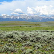
Shrubland, Alpine and Grassland Ecology (SAGE) Wildlife Research Group
The SAGE Wildlife Research Group consists of a large team of research scientists with an interest in conservation and management of wildlife and their ecosystems. Broadly, research involves understanding animal-habitat relationships, with an emphasis on conservation ecology and population demography, and a focus on shrubland, alpine, and grassland ecosystems. We are addressing the effects of...
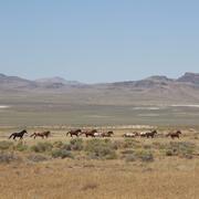
Science for management of America’s iconic wild horses and burros
Wild horses and burros are iconic wildlife of the western USA as well as a complicated management issue on tribal, state, and federal lands. Due to their history as domesticated animals, these wild equids – also called “free-roaming” or “feral” equids – can reproduce quickly, and have few natural predators, allowing their populations to grow rapidly if not managed. When populations are too large...

Greater Sage-Grouse Population Monitoring Framework: Cheat Sheet
The Greater Sage-grouse Population Monitoring Framework fills a prominent information gap to help inform current assessments of sage-grouse population trends at nested spatial and temporal scales. It is centered on four objectives: (1) create a standardized database of lek counts; (2) develop biologically based spatial population structures by clustering leks; (3) estimate spatial trends at...

Greater Sage-Grouse Population Monitoring Framework: Trends Analysis Information Sheet
Land and wildlife managers require accurate estimates of sensitive species’ trends to help guide conservation decisions that maintain biodiversity and promote healthy ecosystems. Accurately assessing greater sage-grouse ( Centrocercus urophasianus; sage-grouse) population trends can be difficult because of (1) missing lek counts or incomplete repeat counts, (2) variation in counts from observer...

Greater Sage-Grouse Population Monitoring Framework: Targeted Annual Warning System Information Sheet
The Greater Sage-grouse Population Monitoring Framework helps fill a major information gap to aid current assessments of sage-grouse population trends across spatial and temporal scales. It centers on four objectives: 1) create a standardized database of lek counts; 2) cluster leks to develop spatial population structures; 3) estimate spatial trends across temporal extents; and 4) develop a system...

Greater Sage-Grouse Population Monitoring Framework: Glossary of Terms
The Greater Sage-grouse Population Monitoring Framework helps aid current assessments of sage-grouse population trends across spatial and temporal scales. It centers on four objectives: 1) create a standardized database of lek counts; 2) cluster leks to develop spatial population structures; 3) estimate spatial trends across temporal extents; and 4) develop a system to estimate where and when...

Data Harmonization for Greater Sage-Grouse Populations
Long-term wildlife monitoring is imperative for understanding population changes that can inform managers. However, working with population data collected by different organizations across multiple jurisdictions and over long time periods can be challenging due to varying data management approaches and organizational priorities. Through this project, we aimed to collaborate with eleven state...

Greater Sage-Grouse Population Monitoring Framework: Frequently Asked Questions
The Greater Sage-grouse Population Monitoring Framework helps aid current assessments of sage-grouse population trends across spatial and temporal scales. It centers on four objectives: 1) create a standardized database of lek counts; 2) cluster leks to develop spatial population structures; 3) estimate spatial trends across temporal extents; and 4) develop a system to estimate where and when...

Greater Sage-Grouse Population Monitoring Framework
Greater sage-grouse ( Centrocercus urophasianus) are at the center of state and national land use policies largely because of their unique life-history traits and their role as an ecological indicator for the health of sagebrush ecosystems. Multiple science centers with the U.S. Geological Survey (USGS) in conjunction with Colorado State University (CSU) have developed the Greater Sage-Grouse...

A user-friendly decision support tool for monitoring and managing greater sage-grouse populations
Researchers at the U.S. Geological Survey (USGS) and Colorado State University (CSU) collaborated with the Bureau of Land Management and state wildlife agencies to develop a hierarchical population monitoring framework for managing greater sage-grouse ( Centrocercus urophasianus) populations and the sagebrush ecosystems they depend on for survival and reproduction. This greater sage-grouse...

Greater Sage-Grouse Population Monitoring Framework Data Inputs Information Sheet
To support management decisions, western state wildlife agencies identified the need for a range-wide database that tracks annual counts of greater sage-grouse ( Centrocercus urophasianus; sage-grouse) at leks (breeding sites), which have been recorded since the early 1950s. Researchers at Colorado State University (CSU) and U.S. Geological Survey (USGS) worked with state wildlife agencies to: 1)...

A targeted annual warning system (TAWS) for identifying aberrant declines in greater sage-grouse populations
Land and wildlife managers require accurate estimates of sensitive species’ trends to help guide conservation decisions that maintain biodiversity and promote healthy ecosystems. Multiple science centers with the U.S. Geological Survey (USGS), in conjunction with Colorado State University (CSU), developed a hierarchical population monitoring framework for managing greater sage-grouse (...
Science and Products
Filter Total Items: 39
Shrubland, Alpine and Grassland Ecology (SAGE) Wildlife Research Group
The SAGE Wildlife Research Group consists of a large team of research scientists with an interest in conservation and management of wildlife and their ecosystems. Broadly, research involves understanding animal-habitat relationships, with an emphasis on conservation ecology and population demography, and a focus on shrubland, alpine, and grassland ecosystems. We are addressing the effects of...
Science for management of America’s iconic wild horses and burros
Wild horses and burros are iconic wildlife of the western USA as well as a complicated management issue on tribal, state, and federal lands. Due to their history as domesticated animals, these wild equids – also called “free-roaming” or “feral” equids – can reproduce quickly, and have few natural predators, allowing their populations to grow rapidly if not managed. When populations are too large...
Greater Sage-Grouse Population Monitoring Framework: Cheat Sheet
The Greater Sage-grouse Population Monitoring Framework fills a prominent information gap to help inform current assessments of sage-grouse population trends at nested spatial and temporal scales. It is centered on four objectives: (1) create a standardized database of lek counts; (2) develop biologically based spatial population structures by clustering leks; (3) estimate spatial trends at...
Greater Sage-Grouse Population Monitoring Framework: Trends Analysis Information Sheet
Land and wildlife managers require accurate estimates of sensitive species’ trends to help guide conservation decisions that maintain biodiversity and promote healthy ecosystems. Accurately assessing greater sage-grouse ( Centrocercus urophasianus; sage-grouse) population trends can be difficult because of (1) missing lek counts or incomplete repeat counts, (2) variation in counts from observer...
Greater Sage-Grouse Population Monitoring Framework: Targeted Annual Warning System Information Sheet
The Greater Sage-grouse Population Monitoring Framework helps fill a major information gap to aid current assessments of sage-grouse population trends across spatial and temporal scales. It centers on four objectives: 1) create a standardized database of lek counts; 2) cluster leks to develop spatial population structures; 3) estimate spatial trends across temporal extents; and 4) develop a system...
Greater Sage-Grouse Population Monitoring Framework: Glossary of Terms
The Greater Sage-grouse Population Monitoring Framework helps aid current assessments of sage-grouse population trends across spatial and temporal scales. It centers on four objectives: 1) create a standardized database of lek counts; 2) cluster leks to develop spatial population structures; 3) estimate spatial trends across temporal extents; and 4) develop a system to estimate where and when...
Data Harmonization for Greater Sage-Grouse Populations
Long-term wildlife monitoring is imperative for understanding population changes that can inform managers. However, working with population data collected by different organizations across multiple jurisdictions and over long time periods can be challenging due to varying data management approaches and organizational priorities. Through this project, we aimed to collaborate with eleven state...
Greater Sage-Grouse Population Monitoring Framework: Frequently Asked Questions
The Greater Sage-grouse Population Monitoring Framework helps aid current assessments of sage-grouse population trends across spatial and temporal scales. It centers on four objectives: 1) create a standardized database of lek counts; 2) cluster leks to develop spatial population structures; 3) estimate spatial trends across temporal extents; and 4) develop a system to estimate where and when...
Greater Sage-Grouse Population Monitoring Framework
Greater sage-grouse ( Centrocercus urophasianus) are at the center of state and national land use policies largely because of their unique life-history traits and their role as an ecological indicator for the health of sagebrush ecosystems. Multiple science centers with the U.S. Geological Survey (USGS) in conjunction with Colorado State University (CSU) have developed the Greater Sage-Grouse...
A user-friendly decision support tool for monitoring and managing greater sage-grouse populations
Researchers at the U.S. Geological Survey (USGS) and Colorado State University (CSU) collaborated with the Bureau of Land Management and state wildlife agencies to develop a hierarchical population monitoring framework for managing greater sage-grouse ( Centrocercus urophasianus) populations and the sagebrush ecosystems they depend on for survival and reproduction. This greater sage-grouse...
Greater Sage-Grouse Population Monitoring Framework Data Inputs Information Sheet
To support management decisions, western state wildlife agencies identified the need for a range-wide database that tracks annual counts of greater sage-grouse ( Centrocercus urophasianus; sage-grouse) at leks (breeding sites), which have been recorded since the early 1950s. Researchers at Colorado State University (CSU) and U.S. Geological Survey (USGS) worked with state wildlife agencies to: 1)...
A targeted annual warning system (TAWS) for identifying aberrant declines in greater sage-grouse populations
Land and wildlife managers require accurate estimates of sensitive species’ trends to help guide conservation decisions that maintain biodiversity and promote healthy ecosystems. Multiple science centers with the U.S. Geological Survey (USGS), in conjunction with Colorado State University (CSU), developed a hierarchical population monitoring framework for managing greater sage-grouse (...