
Water quality
Water quality
Filter Total Items: 41

Technical Assistance to the USDA - NRCS - National Water Management Center
The National Water Management Center (NWMC) serves as a production support center for the U.S. Department of Agriculture - Natural Resources Conservation Service (NRCS). The NWMC consists of an interdisciplinary, multi-agency team of national specialists helping implement water-related projects across the country.

Arkansas Water-Quality Data Program
Short Title: QW Data Program Project Chief: Dwight Lasker Cooperators: U.S. Army Corps of Engineers - Little Rock District, U.S. Fish and Wildlife Service, Bureau of Land Management, Arkansas Natural Resources Commission, Arkansas Geological Survey, Arkansas Department of Environmental Quality, Arkansas Game and Fish Commission, Central Arkansas Water, Hot Springs Village Project Time Frame: 1962...

National Water-Quality Assessment Program (NAWQA) in Tennessee
National Water Quality Assessment Program (NAWQA) in Tennessee

What We Do
About the Louisiana Water Science Center Office Locations What We Do Data Collection Database Capabilities

Mississippi/Atchafalaya River Basins - SPARROW
SPARROW, a modeling tool for the regional interpretation of water-quality monitoring data. The model relates in-stream water-quality measurements to spatially referenced characteristics of watersheds, including contaminant sources and factors influencing terrestrial and aquatic transport. SPARROW empirically estimates the origin and fate of contaminants in river networks and quantifies...

National Water Quality Assessment (NAWQA) Program - Mississippi Embayment Study Area
The National Water-Quality Assessment (NAWQA) Program is designed to describe the status and trends in the quality of the Nation's surface-water and ground-water resources and to provide a sound understanding of the natural and human factors that affect the quality of these resources. As part of the program, investigations will be conducted in approximately 60 areas -- called study units --...

USGS Hurricane-related Publications for Louisiana
USGS Information and Links Hurricane Hazards—A National Threat (fact sheet) USGS Natural Hazards - Hurricanes Hurricane Forecast Information National Hurricane Center—(NWS) Current Tropical Forecast Information GOES-8 Atlantic Infrared Imagery GOES-8 Atlantic Visible Imagery Earth Scan Laboratory—(LSU) GOES-8 Atlantic Infrared Imagery GOES-8 Atlantic Visible Imagery GOES-8 Atlantic Color Infrared...

Turbidity Monitoring in Tennessee
A study involving suspended-sediment and turbidity monitoring at streamgaging stations near the segment of State Route 840 under construction between Fairview and Bending Chestnut.

Tennessee River (TENN) Basin Study
The Tennessee (TENN) River Basin encompasses an area of 40,890 square miles, making it the largest tributary to the Ohio River. The Tennessee River flows through portions of seven states: Virginia, North Carolina, Tennessee, Alabama, Georgia, Mississippi, and Kentucky.
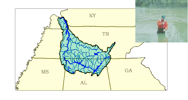
Lower Tennessee River (LTEN) Basin Study
Welcome....the Lower Tennessee River Basin in Tennessee, Alabama, Georgia, Kentucky, and Mississippi is one of the 59 study units that are part of the U.S. Geological Survey's National Water-Quality Assessment (NAWQA) Program.The long-term goals of this program are to describe the status and trends in the quality of a large, representative part of the Nation's surface- and ground-water resources...

Mobile River Basin Study Design
The Mobile River Basin study is one of several NAWQA studies that began in Federal fiscal year 1997 (October 1996). Study planning and design, and analysis of existing data will be done during the first 2 years, which is consistent with all NAWQA studies. After the 2-year planning period, surface- and ground-water and biological data will be collected intensively for 3 years during a high...

Testing for Agricultural Runoff in the Missouri River - Video
Ride along as USGS scientists Richard Coupe and Joe Schatz sample the Missouri River near Hermann, Missouri. To view the video click here.