
The Hydrologic Interpretive Branch collaborates with stakeholders to design, execute, and publish scientific studies that address issues associated with water resources at local, regional, and national scales. This branch has three sections that focus on watershed and urban hydrology, integrated modeling of hydrologic systems, and the development of new statistical and geospatial tools.
Watershed and Urban Hydrology Section
Section Chief: Kirk Smith
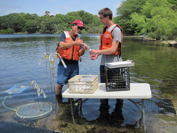
New England is home to thousands of watersheds. The Watershed and Urban Hydrology Section studies hydrologic and water-quality processes across the full range of New England landscapes, from the pristine northern Appalachian Mountains to densely populated cities near the Atlantic coast. Rainfall-runoff processes and related chemical transport in the Sleepers River Watershed in northern Vermont have been a research focus for decades. Additionally, scientists studied the sources of chloride and other constituents in the public water-supply watersheds of Providence, Rhode Island, and Cambridge, Massachusetts, to inform water-supply protection efforts. In another urban study, scientists pioneered new methods for continuous quantification of stormwater runoff volume and constituent loads entering a large river from highway bridge decks.
Integrated Modeling Section
Section Chief: Alana Spaetzel
Integrated assessments of hydrologic systems are essential for effective water management. Our center uses state-of-the-art computational modeling and statistical tools to assess groundwater and surface-water availability and quality over space and time. Scientists study how the physical and geochemical characteristics of hydrologic systems are affected by human activity, such as drought effects on concentrations of arsenic in well water; the transport of known toxic chemicals, like per- and polyfluoroalkyl substances in soils, surface water, and groundwater; and how chemicals of emerging concern (including pharmaceuticals, hormones, and 1,4-dioxane) move through groundwater systems. The transport and discharge of dissolved nitrogen in the coastal regions of southern New England also are a particular focus area.
This information helps stakeholders make data-driven decisions about the management of water resources and the protection of human and ecosystem health. Additionally, scientists study the amount of water available for public use that would not degrade the surrounding ecosystem.
Statistical and Geospatial Section
Section Chief: Robert Dudley
The Statistical and Geospatial Section uses advanced statistical methods and geospatial tools to better understand the behavior of hydrologic systems at a wide range of spatial scales. For example, scientists compared modeled and observed streamflow trends from 1984 to 2016 at 502 minimally developed basins across the United States using several types of statistical models and a deterministic, process-based model. At the local scale, scientists developed and applied a modeling tool (the Stochastic Empirical Loading and Dilution Model, or SELDM) that allows users to estimate the probability of stormwater flows, constituent concentrations and loads exceeding user-selected values. Scientists also are engaged in characterizing pluvial flooding and compound flooding, particularly in southern New England.
The Hydrologic Interpretive Branch collaborates with stakeholders to design, execute, and publish scientific studies that address issues associated with water resources at local, regional, and national scales. This branch has three sections that focus on watershed and urban hydrology, integrated modeling of hydrologic systems, and the development of new statistical and geospatial tools.
Watershed and Urban Hydrology Section
Section Chief: Kirk Smith
New England is home to thousands of watersheds. The Watershed and Urban Hydrology Section studies hydrologic and water-quality processes across the full range of New England landscapes, from the pristine northern Appalachian Mountains to densely populated cities near the Atlantic coast. Rainfall-runoff processes and related chemical transport in the Sleepers River Watershed in northern Vermont have been a research focus for decades. Additionally, scientists studied the sources of chloride and other constituents in the public water-supply watersheds of Providence, Rhode Island, and Cambridge, Massachusetts, to inform water-supply protection efforts. In another urban study, scientists pioneered new methods for continuous quantification of stormwater runoff volume and constituent loads entering a large river from highway bridge decks.
Integrated Modeling Section
Section Chief: Alana Spaetzel
Integrated assessments of hydrologic systems are essential for effective water management. Our center uses state-of-the-art computational modeling and statistical tools to assess groundwater and surface-water availability and quality over space and time. Scientists study how the physical and geochemical characteristics of hydrologic systems are affected by human activity, such as drought effects on concentrations of arsenic in well water; the transport of known toxic chemicals, like per- and polyfluoroalkyl substances in soils, surface water, and groundwater; and how chemicals of emerging concern (including pharmaceuticals, hormones, and 1,4-dioxane) move through groundwater systems. The transport and discharge of dissolved nitrogen in the coastal regions of southern New England also are a particular focus area.
This information helps stakeholders make data-driven decisions about the management of water resources and the protection of human and ecosystem health. Additionally, scientists study the amount of water available for public use that would not degrade the surrounding ecosystem.
Statistical and Geospatial Section
Section Chief: Robert Dudley
The Statistical and Geospatial Section uses advanced statistical methods and geospatial tools to better understand the behavior of hydrologic systems at a wide range of spatial scales. For example, scientists compared modeled and observed streamflow trends from 1984 to 2016 at 502 minimally developed basins across the United States using several types of statistical models and a deterministic, process-based model. At the local scale, scientists developed and applied a modeling tool (the Stochastic Empirical Loading and Dilution Model, or SELDM) that allows users to estimate the probability of stormwater flows, constituent concentrations and loads exceeding user-selected values. Scientists also are engaged in characterizing pluvial flooding and compound flooding, particularly in southern New England.