
Great Salt Lake - Fifty years of change through satellite images
The completion of the Railroad Causeway in 1959 divided the Great Salt Lake in half. Because all of the freshwater inflows enter the southern part of the lake, the north arm became much more saline than the south; well defined in the satellite images. Several years of greater than normal precipitation resulted in a large increase in the lake’s area during the early 1980's and the creation of a new evaporation basin west of the lake. During this time the causeway was also breached to provide new exchange of flow between the north and south arms. Subsequent years of drought and increased use of inflows have brought the lake to record low levels.

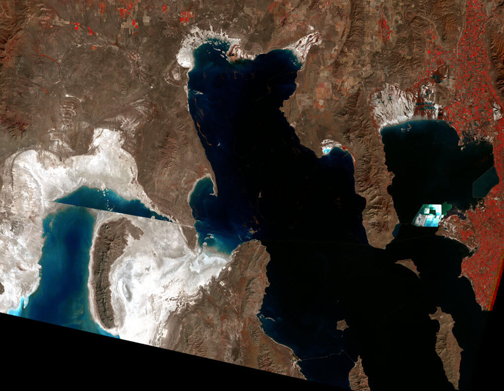
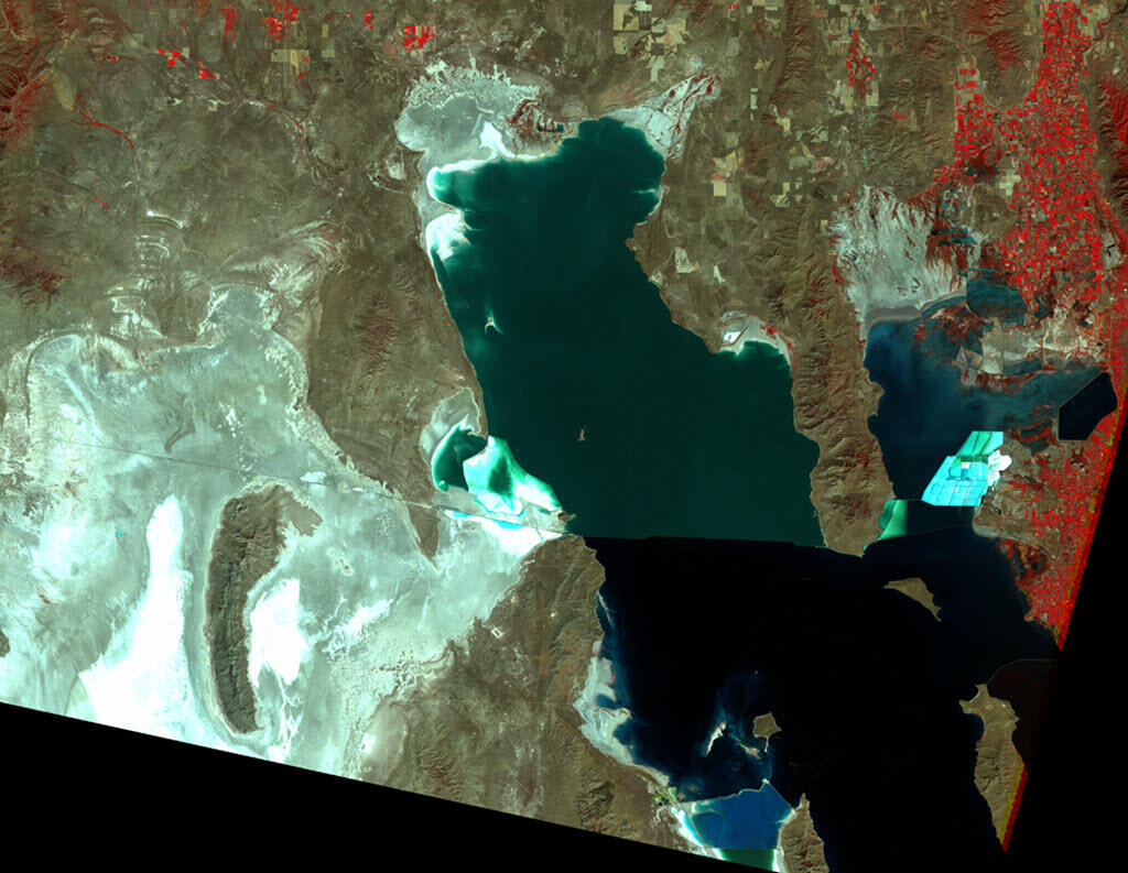
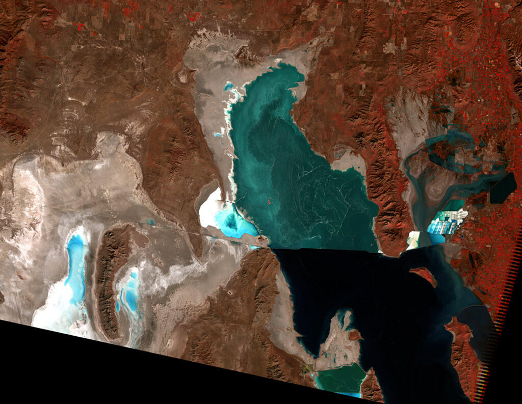
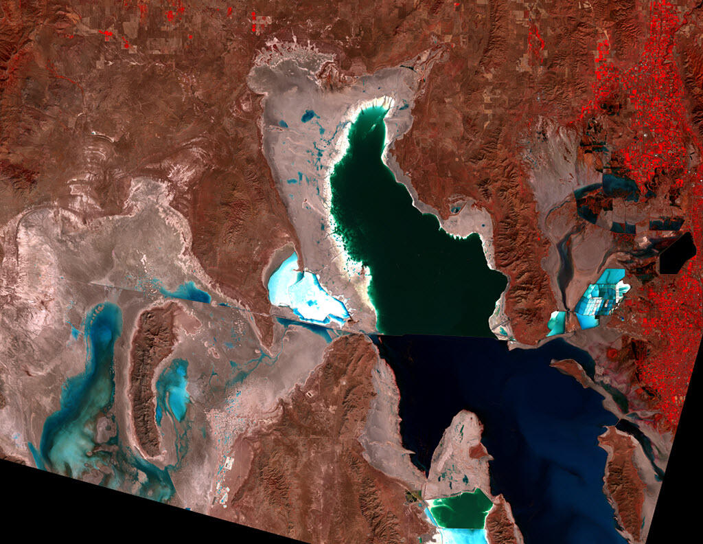

False-Color Composite Satellite Imagery
Differences in coloration of the false-color infrared imagery in the satellite image map are due to physical, chemical, and biological factors. Terrestrial vegetation appears as bright red throughout the mountains and as well-defined patches in urban areas to the east of the lake. The white coloration adjacent to the lake on the north and west represents reflection from open salt-flat areas. Light blue coloration in shorelines and ponds on the east and west side of the lake is due to shallow water areas such as ponds constructed for salt extraction. The sharp line extending east and west across the middle of the lake is the railroad causeway that separates the lake into Gunnison Bay to the north and Gilbert Bay to the south. The difference in coloration of each bay is due to Gunnison Bay having much greater salt content that changes the reflection and supports several species of extreme halophyllic bacteria. Gilbert Bay is less saline and is characterized by several species of algae that reflect differently depending on the salinity. The differences are very prominent in the image for 2011.
Great Salt Lake
The Great Salt Lake is a terminal lake, with no outlet rivers running to the ocean. Since water leaves the lake only through evaporation, it leaves behind its dissolved minerals, making the lake up to 8 times as salty as seawater.
The lack of outlets also means the lake responds dramatically to change in inflow. Rainy weather beginning in 1982 brought the highest levels in recorded history, peaking in June 1986 and March–April 1987. The lake is shallow for its size—about 70 miles long and 30 miles wide, but only about 40 feet deep. Because the lake basin is defined by very shallow slopes, the lake responds to increased inflow by spreading. Because of this spread, highways, causeways, and parts of Salt Lake City were flooded or threatened in the 1980s, costing millions of dollars.
A report by Utah State University and others indicated that the lake has persistently declined since the mid-1800s: "consumptive water use has reduced net river inflow to the lake by 39 percent over the past 150 years."
The Causeway
One of the first flood-control measures involved the railroad causeway, a solid raised roadway cutting east to west across the lake. The first transcontinental railroad, completed in 1869, had to go around the lake and over the Promontory Mountains to the north. In 1902, the Southern Pacific Railroad constructed a new line directly across the lake so that engines would not have to climb over the mountains. For 12 miles, this route crossed a trestle, like a low bridge, made of 28,000 wooden pilings. In 1957–1959, this trestle was replaced by the causeway—a solid raised roadway made of 50 million cubic yards of rock, sand, and gravel. This causeway was safer and allowed faster speeds.
But unlike the trestle, which allowed water to circulate freely underneath for 12 miles, the causeway had only two 15-foot culverts. The causeway was constructed of semipermeable material, which reduced north-south flow and split the lake into two parts. The south part received most of the lake’s inflow from rivers, so it became higher than the north part. The northern part also became saltier, causing different types of algae and bacteria to grow, which made it look pink, while the southern part of the lake remained bluer. You should be able to see this subtle difference in the 1972 Landsat image (in this image, reflectance in the visible-red range is represented by green).
By July 1, 1984, after two years of above-normal precipitation, the south part of the lake was 3.7 feet higher than the north, the highest difference it would ever reach. By August 3 of that year, a 300-foot section of the causeway was replaced by a low bridge, allowing water to flow underneath. Within 2 months, the difference between the south and north fell to 0.75 feet, and within a year it was only 0.5 feet. Although this was done as a flood-control measure, it also had the effect of reducing the difference in salt concentration. By 1987, the north-south difference visible in Landsat images was reduced.
Once the levels began dropping again, a clear color distinction between the north and south arms of the lake returned.
By 2013, the bridge constructed in 1984 was out of water due to declining lake levels and water flowed once again from one side of the lake to the other through only two culverts near the center of the causeway. In December 2013, concern about the structural integrity of the culverts resulted in their removal. After about three years of separation, a new bridge was completed near the middle of the causeway and the channel opened December 1, 2016. This new connection created a unique opportunity to study the re-formation of the deep brine layer in Gilbert Bay.
Learn more about the Deep Brine Layer.
The Evaporation Basin
In June 1986, the State of Utah began construction of a system to pump excess water from the lake onto the Bonneville Salt Flats, creating the Newfoundland Evaporation Basin. This project included a pumping station at Hogup Ridge, inlet and outlet canals, four trestles, almost 25 miles of dikes, a 37-mile natural-gas pipeline, and a 10-mile access road between Lakeside and the pumping station. Pumps ran from April 1987 until June 1989, by which time the lake had dropped almost 6 feet. The pumping caused about 2 feet of that drop.
In the first year, about 1.5 million acre-feet of water was pumped into the evaporation basin (an acre-foot is a volume that would cover one acre with one foot of water). A dike was built at the southeast end of the basin to control the basin’s water level and let salt-rich water flow back into the lake. If the level of the basin rose high enough, some water would travel all the way around the Newfoundland Mountains and back into the lake. Over the course of the project about 264,000–283,000 acre-feet of water actually did so.
The completion of the Railroad Causeway in 1959 divided the Great Salt Lake in half. Because all of the freshwater inflows enter the southern part of the lake, the north arm became much more saline than the south; well defined in the satellite images. Several years of greater than normal precipitation resulted in a large increase in the lake’s area during the early 1980's and the creation of a new evaporation basin west of the lake. During this time the causeway was also breached to provide new exchange of flow between the north and south arms. Subsequent years of drought and increased use of inflows have brought the lake to record low levels.
False-Color Composite Satellite Imagery
Differences in coloration of the false-color infrared imagery in the satellite image map are due to physical, chemical, and biological factors. Terrestrial vegetation appears as bright red throughout the mountains and as well-defined patches in urban areas to the east of the lake. The white coloration adjacent to the lake on the north and west represents reflection from open salt-flat areas. Light blue coloration in shorelines and ponds on the east and west side of the lake is due to shallow water areas such as ponds constructed for salt extraction. The sharp line extending east and west across the middle of the lake is the railroad causeway that separates the lake into Gunnison Bay to the north and Gilbert Bay to the south. The difference in coloration of each bay is due to Gunnison Bay having much greater salt content that changes the reflection and supports several species of extreme halophyllic bacteria. Gilbert Bay is less saline and is characterized by several species of algae that reflect differently depending on the salinity. The differences are very prominent in the image for 2011.
Great Salt Lake
The Great Salt Lake is a terminal lake, with no outlet rivers running to the ocean. Since water leaves the lake only through evaporation, it leaves behind its dissolved minerals, making the lake up to 8 times as salty as seawater.
The lack of outlets also means the lake responds dramatically to change in inflow. Rainy weather beginning in 1982 brought the highest levels in recorded history, peaking in June 1986 and March–April 1987. The lake is shallow for its size—about 70 miles long and 30 miles wide, but only about 40 feet deep. Because the lake basin is defined by very shallow slopes, the lake responds to increased inflow by spreading. Because of this spread, highways, causeways, and parts of Salt Lake City were flooded or threatened in the 1980s, costing millions of dollars.
A report by Utah State University and others indicated that the lake has persistently declined since the mid-1800s: "consumptive water use has reduced net river inflow to the lake by 39 percent over the past 150 years."
The Causeway
One of the first flood-control measures involved the railroad causeway, a solid raised roadway cutting east to west across the lake. The first transcontinental railroad, completed in 1869, had to go around the lake and over the Promontory Mountains to the north. In 1902, the Southern Pacific Railroad constructed a new line directly across the lake so that engines would not have to climb over the mountains. For 12 miles, this route crossed a trestle, like a low bridge, made of 28,000 wooden pilings. In 1957–1959, this trestle was replaced by the causeway—a solid raised roadway made of 50 million cubic yards of rock, sand, and gravel. This causeway was safer and allowed faster speeds.
But unlike the trestle, which allowed water to circulate freely underneath for 12 miles, the causeway had only two 15-foot culverts. The causeway was constructed of semipermeable material, which reduced north-south flow and split the lake into two parts. The south part received most of the lake’s inflow from rivers, so it became higher than the north part. The northern part also became saltier, causing different types of algae and bacteria to grow, which made it look pink, while the southern part of the lake remained bluer. You should be able to see this subtle difference in the 1972 Landsat image (in this image, reflectance in the visible-red range is represented by green).
By July 1, 1984, after two years of above-normal precipitation, the south part of the lake was 3.7 feet higher than the north, the highest difference it would ever reach. By August 3 of that year, a 300-foot section of the causeway was replaced by a low bridge, allowing water to flow underneath. Within 2 months, the difference between the south and north fell to 0.75 feet, and within a year it was only 0.5 feet. Although this was done as a flood-control measure, it also had the effect of reducing the difference in salt concentration. By 1987, the north-south difference visible in Landsat images was reduced.
Once the levels began dropping again, a clear color distinction between the north and south arms of the lake returned.
By 2013, the bridge constructed in 1984 was out of water due to declining lake levels and water flowed once again from one side of the lake to the other through only two culverts near the center of the causeway. In December 2013, concern about the structural integrity of the culverts resulted in their removal. After about three years of separation, a new bridge was completed near the middle of the causeway and the channel opened December 1, 2016. This new connection created a unique opportunity to study the re-formation of the deep brine layer in Gilbert Bay.
Learn more about the Deep Brine Layer.
The Evaporation Basin
In June 1986, the State of Utah began construction of a system to pump excess water from the lake onto the Bonneville Salt Flats, creating the Newfoundland Evaporation Basin. This project included a pumping station at Hogup Ridge, inlet and outlet canals, four trestles, almost 25 miles of dikes, a 37-mile natural-gas pipeline, and a 10-mile access road between Lakeside and the pumping station. Pumps ran from April 1987 until June 1989, by which time the lake had dropped almost 6 feet. The pumping caused about 2 feet of that drop.
In the first year, about 1.5 million acre-feet of water was pumped into the evaporation basin (an acre-foot is a volume that would cover one acre with one foot of water). A dike was built at the southeast end of the basin to control the basin’s water level and let salt-rich water flow back into the lake. If the level of the basin rose high enough, some water would travel all the way around the Newfoundland Mountains and back into the lake. Over the course of the project about 264,000–283,000 acre-feet of water actually did so.