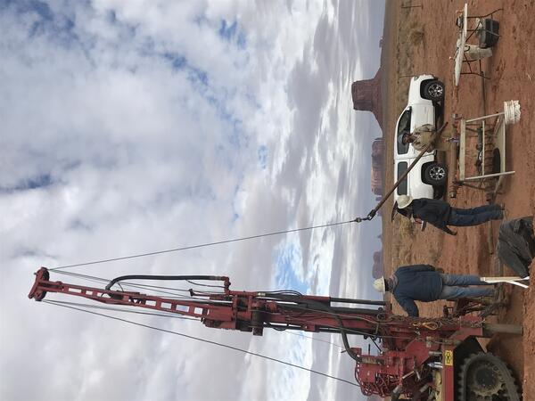
David O'Leary
David is the director of the USGS Utah Water Science Center.
Previously David served as Investigative Section Studies Chief of the USGS Utah Water Science Center, a Studies Chief with the USGS California Water Science Center, and a project hydrologist with the USGS California Water Science Center. David's studies have focused on understanding the physical and geochemical hydrology of desert and coastal aquifer systems including work related to natural and artificial recharge processes in desert environments and chloride intrusion in deltaic systems. He has been with the USGS since 2006.
Education and Certifications
B.S. Geology, Colorado State University
M.S. Hydrology, San Diego State University
Science and Products
Groundwater Conditions in Utah
Since 1964, the U.S. Geological Survey, the Utah Department of Natural Resources, Division of Water Rights, and the Utah Department of Environmental Quality, Division of Water Quality have cooperatively published an annual report describing groundwater conditions in Utah. The annual paper reports provided data that enabled interested parties to maintain awareness of changing groundwater conditions...
Determining the fate and transport of septic-tank effluent in the southern area of Warren subbasin, California
Residents and businesses in Yucca Valley, CA rely currently on septic tanks to treat their wastewater. The local water district, Hi-Desert Water District (HDWD), is planning to construct a sewer system and wastewater treatment plant, initially serving the West, Midwest, Mideast, Northeast, and East hydrogeologic units of the Warren subbasin.
San Antonio Creek Water Availability
Located in Santa Barbara County, California, the San Antonio Creek Groundwater Basin is a rural agricultural area that is reliant on local water supplies, predominantly groundwater. Because of the growth of irrigated agriculture in the area, water demands have increased significantly, taxing local groundwater supplies. Groundwater resources are also used to supply local inhabitants, as well as...
Great Salt Lake - Fifty years of change through satellite images
The completion of the Railroad Causeway in 1959 divided the Great Salt Lake in half. Because all of the freshwater inflows enter the southern part of the lake, the north arm became much more saline than the south; well defined in the satellite images. Several years of greater than normal precipitation resulted in a large increase in the lake’s area during the early 1980's and the creation of a new...
Bibliography of hydrological and ecological research in the Great Basin terminal lakes, USA
This database contains literature citations and associated abstracts pertaining to the ecology and hydrology of terminal lakes in the Great Basin region of the western United States. This is not meant to be an exhaustive list, nor did we perform a systematic meta-analysis; rather, literature records were included based on topical relevance.
Data Release of hydrogeologic data from the San Antonio Creek Valley watershed, Santa Barbara County, California, 2015-2019
The San Antonio Creek Valley watershed (SACVW) is located in western Santa Barbara County about 15 miles (mi) south of Santa Maria, California and 55 mi north of Santa Barbara, California. The SACVW, is about 140 square miles and encompasses the San Antonio Creek Valley groundwater basin. Since the late 1800s, groundwater has been the primary source of water for agricultural, military...
Filter Total Items: 14
Imperiled Great Basin terminal lakes: Synthesizing ecological and hydrological science gaps and research needs for waterbird conservation
Terminal lakes are declining globally because of human water demands, drought, and climate change. Through literature synthesis and feedback from the resource and conservation community, we review the state of research for terminal lakes in the Great Basin of the United States, which support millions of waterbirds annually, to prioritize ecological and hydrologic information needs. From...
Authors
Garth Herring, Ashley L. Whipple, Cameron L. Aldridge, Bryce Alan Pulver, Collin A. Eagles-Smith, Rich D. Inman, Elliott Matchett, Adrian P. Monroe, Elizabeth Kari Orning, Benjamin Seward Robb, Jessica E. Shyvers, Bryan C. Tarbox, Nathan D. Van Schmidt, Cassandra Smith, Matthew J. Holloran, Cory T. Overton, David O'Leary, Michael L. Casazza, Rebecca Frus
By
Ecosystems Mission Area, Water Resources Mission Area, Species Management Research Program, Water Availability and Use Science Program, Forest and Rangeland Ecosystem Science Center, Fort Collins Science Center, Nevada Water Science Center, Oregon Water Science Center, Utah Water Science Center, Western Ecological Research Center (WERC), Saline Lake Ecosystems Integrated Water Availability Assessment
Integrated science strategy for assessing and monitoring water availability and migratory birds for terminal lakes across the Great Basin, United States
Executive SummaryIn 2022, the U.S. Geological Survey (USGS) established the Saline Lake Ecosystems Integrated Water Availability Assessment (IWAAs) to monitor and assess the hydrology of terminal lakes in the Great Basin and the migratory birds and other wildlife dependent on those habitats. Scientists from across the USGS (with specialties in water quantity, water quality, limnology...
Authors
Rebecca J. Frus, Cameron L. Aldridge, Michael L. Casazza, Collin A. Eagles-Smith, Garth Herring, Scott A. Hynek, Daniel K. Jones, Susan K Kemp, Thomas M. Marston, Christopher M. Morris, Ramon C. Naranjo, Cee Nell, David R. O'Leary, Cory T. Overton, Bryce A. Pulver, Brian E. Reichert, Christine A. Rumsey, Rudy Schuster, Cassandra D. Smith
Rocky Mountain Region Science Exchange 2020—EarthMAP and the Colorado River Basin
The U.S. Geological Survey (USGS) Rocky Mountain Region (RMR) hosted USGS scientists, managers, program coordinators, and leadership team members for a virtual Science Exchange during September 15–17, 2020. The Science Exchange had 216 registered participants and included 48 talks over the 3-day period. Invited speakers presented information about the novel USGS Earth Monitoring...
Authors
Anne C. Tillery, Patrick J. Anderson, William J. Andrews, Katharine Dahm, Seth S. Haines, Robert Horton, David O'Leary, Ryan D. Taylor, Kathryn A. Thomas, Alicia Torregrosa
By
Ecosystems Mission Area, Water Resources Mission Area, Fort Collins Science Center, Geology, Geophysics, and Geochemistry Science Center, New Mexico Water Science Center, Oklahoma-Texas Water Science Center, Southwest Biological Science Center, Utah Water Science Center, Western Geographic Science Center, Colorado River Basin: Actionable and Strategic Integrated Science and Technology
Summary of hydrologic testing, wellbore-flow data, and expanded water-level and water-quality data, 2011–15, Fort Irwin National Training Center, San Bernardino County, California
In view of the U.S. Army’s historical reliance and plans to increase demands on groundwater to supply its operations at Fort Irwin National Training Center (NTC), California, coupled with the continuing water-level declines in some developed groundwater basins as a result of pumping, the U.S. Geological Survey (USGS), in cooperation with the U.S. Army, evaluated the water resources...
Authors
Joseph M. Nawikas, Jill N. Densmore, David R. O'Leary, David C. Buesch, John A. Izbicki
Water-resources and land-surface deformation evaluation studies at Fort Irwin National Training Center, Mojave Desert, California
The U.S. Army Fort Irwin National Training Center (NTC), in the Mojave Desert, obtains all of its potable water supply from three groundwater basins (Irwin, Langford, and Bicycle) within the NTC boundaries (fig. 1; California Department of Water Resources, 2003). Because of increasing water demands at the NTC, the U.S. Geological Survey (USGS), in cooperation with the U.S. Army...
Authors
Jill N. Densmore, Justine E. Dishart, David M. Miller, David C. Buesch, Lyndsay B. Ball, Paul A. Bedrosian, Linda R. Woolfenden, Geoffrey Cromwell, Matthew K. Burgess, Joseph Nawikas, David O'Leary, Adam Kjos, Michelle Sneed, Justin T. Brandt
Selected techniques for monitoring water movement through unsaturated alluvium during managed aquifer recharge
Managed aquifer recharge is used to augment natural recharge to aquifers. It can be used to replenish aquifers depleted by pumping or to store water during wetter years for withdrawal during drier years. Infiltration from ponds is a commonly used, inexpensive approach for managed aquifer recharge.At some managed aquifer-recharge sites, the time when infiltrated water arrives at the water...
Authors
Joseph M. Nawikas, David R. O'Leary, John A. Izbicki, Matthew K. Burgess
Sources of high-chloride water and managed aquifer recharge in an alluvial aquifer in California, USA
As a result of pumping in excess of recharge, water levels in alluvial aquifers within the Eastern San Joaquin Groundwater Subbasin, 130 km east of San Francisco (California, USA), declined below sea level in the early 1950s and have remained so to the present. Chloride concentrations in some wells increased during that time and exceeded the US Environmental Protection Agency’s secondary...
Authors
David O'Leary, John A. Izbicki, Loren F. Metzger
Hydrogeologic data and water-quality data from a thick unsaturated zone at a proposed wastewater-treatment facility site, Yucca Valley, San Bernardino County, California, 2008-11
The Hi-Desert Water District, in the community of Yucca Valley, California, is considering constructing a wastewater-treatment facility and using the reclaimed water to recharge the aquifer system through surface spreading. The Hi-Desert Water District is concerned with possible effects of this recharge on water quality in the underlying groundwater system; therefore, an unsaturated-zone...
Authors
David O'Leary, Dennis A. Clark, John A. Izbicki
Storage and mobilization of natural and septic nitrate in thick unsaturated zones, California
Mobilization of natural and septic nitrate from the unsaturated zone as a result of managed aquifer recharge has degraded water quality from public-supply wells near Yucca Valley in the western Mojave Desert, California. The effect of nitrate storage and potential for denitrification in the unsaturated zone to mitigate increasing nitrate concentrations were investigated. Storage of water...
Authors
John A. Izbicki, Alan L. Flint, David R. O'Leary, Tracy Nishikawa, Peter Martin, Russell D. Johnson, Dennis A. Clark
In-situ arsenic removal during groundwater recharge through unsaturated alluvium
OBJECTIVES The purpose of this study was to determine the feasibility and sustainability of in-situ removal of arsenic from water infiltrated through unsaturated alluvium. BACKGROUND Arsenic is naturally present in aquifers throughout the southwestern United States and elsewhere. In January 2006, the U.S. Environmental Protection Agency (EPA) lowered the Maximum Contaminant Level (MCL)...
Authors
David O'Leary, John A. Izbicki, T.J. Kim, Clark Ajawani, Donald Suarez, Thomas Barnes, Thomas Kulp, Matthew K. Burgess, Iwen Tseng
Movement of water infiltrated from a recharge basin to wells
Local surface water and stormflow were infiltrated intermittently from a 40-ha basin between September 2003 and September 2007 to determine the feasibility of recharging alluvial aquifers pumped for public supply, near Stockton, California. Infiltration of water produced a pressure response that propagated through unconsolidated alluvial-fan deposits to 125 m below land surface (bls) in...
Authors
David R. O'Leary, John A. Izbicki, Jean E. Moran, Tanya Meeth, Brandon Nakagawa, Loren Metzger, Chris Bonds, Michael J. Singleton
Groundwater data for selected wells within the Eastern San Joaquin Groundwater Subbasin, California, 2003-8
Data were collected by the U.S. Geological Survey from 2003 through 2008 in the Eastern San Joaquin Groundwater Subbasin, 80 miles east of San Francisco, California, as part of a study of the increasing chloride concentrations in groundwater processes. Data collected include geologic, geophysical, chemical, and hydrologic data collected during and after the installation of five multiple...
Authors
Dennis A. Clark, John A. Izbicki, Loren F. Metzger, Rhett R. Everett, Gregory A. Smith, David R. O'Leary, Nicholas F. Teague, Matthew K. Burgess