
Henrico County Hydrologic Monitoring Network
The USGS Virginia and West Virginia Water Science Center has established a comprehensive network of hydrologic monitoring stations throughout Henrico County. Precipitation and water-level data collected from these stations are used to inform floodplain management, reduce the risk of flooding, and inform emergency management. On this page, you can access our data and learn more about the Henrico County hydrologic monitoring network.
Monitoring Locations
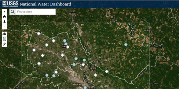
View Henrico County hydrologic monitoring network locations and data on the USGS National Water Dashboard
Monitoring Data
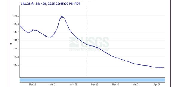
View Henrico County hydrologic monitoring network water level and precipitation data on USGS Water Data for the Nation.
Background
Henrico County is a predominantly suburban area north of Richmond, Virginia. The county's flat to gently rolling landscapes, low elevation, and proximity to the James and Chickahominy Rivers make flooding a concern, especially in areas adjacent to water bodies and in low-lying regions. As climate patterns shift, Henrico County is also seeing rising temperatures, changing precipitation patterns, and more frequent extreme weather events. In addition to increasing flooding risks, these changes can also put extra strain on the county's water resources.
To meet the challenges of shifting climate patterns and increasing risks of extreme weather, Henrico County has partnered with the U.S. Geological Survey to establish a comprehensive, county-wide hydrologic monitoring network. Data collected from this network will help managers in Henrico County:
- Inform floodplain management
- Reduce flood risks
- Inform emergency management strategies
- Inform how future changes to climate and land use might affect local hydrology
Data Collection Methods
Streamflow Monitoring
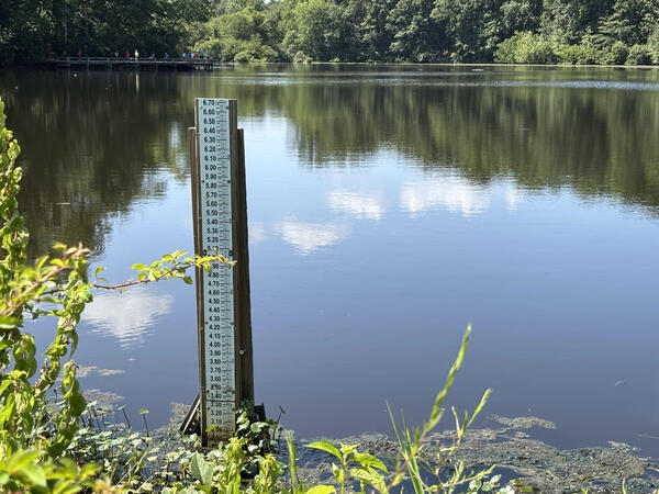
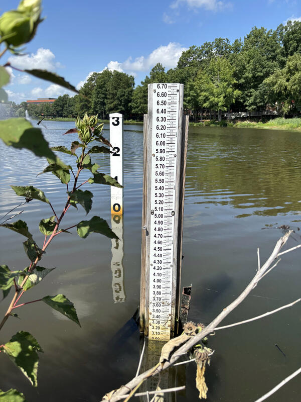
Streamflow is calculated for each location according to published USGS methods for the operation of streamgages (Sauer, 2002; Turnipseed and others, 2010). Water depth data will be collected every 5 minutes, then used to calculate streamflow using a streamflow rating curve, which is a unique mathematical relationship between water depth and streamflow calculated at each stream gaging location. Periodic direct measurements of streamflow are also made to capture variability and changes in hydrologic and geomorphic conditions.
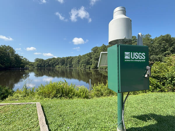
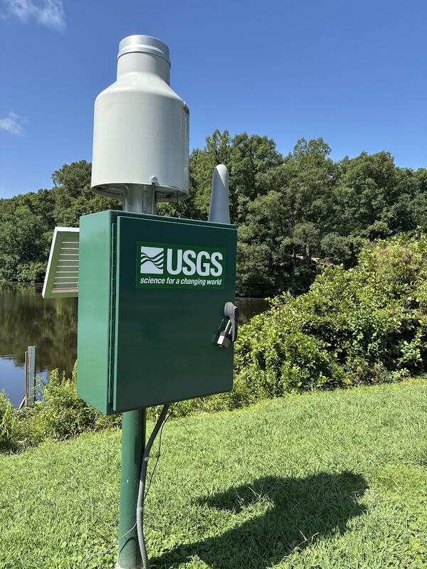
Precipitation Monitoring
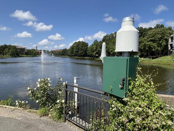
Precipitation is a major driver of changes in stream water levels as well as changes to stream geomorphology, so understanding the timing and intensity of precipitation is necessary for understanding any hydrologic system. In urban areas, impervious surfaces such as roads and parking lots prevent rainwater from seeping into the ground. This water instead travels quickly over land as runoff, and large volumes of runoff can increase peak streamflow during and after precipitation events. More frequent and/or intense rain events can exacerbate these effects.
Precipitation is monitored using a weighing-type gage following published USGS procedures (U.S. Geological Survey, 2009). These precipitation gages provide cumulative precipitation accumulation and intensity data at 5-minute intervals.
«Return to Urban Studies at the Virginia & West Virginia Water Science Center
Henrico County Hydrologic Monitoring Network Photos
The USGS Virginia and West Virginia Water Science Center has established a comprehensive network of hydrologic monitoring stations throughout Henrico County. Precipitation and water-level data collected from these stations are used to inform floodplain management, reduce the risk of flooding, and inform emergency management. On this page, you can access our data and learn more about the Henrico County hydrologic monitoring network.
Monitoring Locations
View Henrico County hydrologic monitoring network locations and data on the USGS National Water Dashboard
Monitoring Data
View Henrico County hydrologic monitoring network water level and precipitation data on USGS Water Data for the Nation.
Background
Henrico County is a predominantly suburban area north of Richmond, Virginia. The county's flat to gently rolling landscapes, low elevation, and proximity to the James and Chickahominy Rivers make flooding a concern, especially in areas adjacent to water bodies and in low-lying regions. As climate patterns shift, Henrico County is also seeing rising temperatures, changing precipitation patterns, and more frequent extreme weather events. In addition to increasing flooding risks, these changes can also put extra strain on the county's water resources.
To meet the challenges of shifting climate patterns and increasing risks of extreme weather, Henrico County has partnered with the U.S. Geological Survey to establish a comprehensive, county-wide hydrologic monitoring network. Data collected from this network will help managers in Henrico County:
- Inform floodplain management
- Reduce flood risks
- Inform emergency management strategies
- Inform how future changes to climate and land use might affect local hydrology
Data Collection Methods
Streamflow Monitoring
Streamflow is calculated for each location according to published USGS methods for the operation of streamgages (Sauer, 2002; Turnipseed and others, 2010). Water depth data will be collected every 5 minutes, then used to calculate streamflow using a streamflow rating curve, which is a unique mathematical relationship between water depth and streamflow calculated at each stream gaging location. Periodic direct measurements of streamflow are also made to capture variability and changes in hydrologic and geomorphic conditions.
Precipitation Monitoring
Precipitation is a major driver of changes in stream water levels as well as changes to stream geomorphology, so understanding the timing and intensity of precipitation is necessary for understanding any hydrologic system. In urban areas, impervious surfaces such as roads and parking lots prevent rainwater from seeping into the ground. This water instead travels quickly over land as runoff, and large volumes of runoff can increase peak streamflow during and after precipitation events. More frequent and/or intense rain events can exacerbate these effects.
Precipitation is monitored using a weighing-type gage following published USGS procedures (U.S. Geological Survey, 2009). These precipitation gages provide cumulative precipitation accumulation and intensity data at 5-minute intervals.
«Return to Urban Studies at the Virginia & West Virginia Water Science Center