
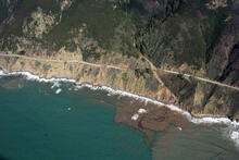
Big Sur coast just north of Kirk Creek

Detailed Description
A two-day rainstorm from January 26-28, 2021 caused numerous mudslides, debris flows, and other issues along California's coastal Highway 1 through Big Sur. This section is just north of Kirk Creek, at a drainage where mud was washed across the roadway. Plumes of the muddy runoff are clearly visible in the ocean.
Sources/Usage
Public Domain.
Related

Remote Sensing Coastal Change
We use remote-sensing technologies—such as aerial photography, satellite imagery, structure-from-motion (SfM) photogrammetry, and lidar (laser-based surveying)—to measure coastal change along U.S. shorelines.

Landscape Response to Disturbance
This project characterizes and measures sediment-related effects of landscape disturbances (such as major storms, drought, or wildfire) and river management. We focus primarily on the U.S. west coast, and our work relates to natural hazards and resource management.
Related
Remote Sensing Coastal Change
We use remote-sensing technologies—such as aerial photography, satellite imagery, structure-from-motion (SfM) photogrammetry, and lidar (laser-based surveying)—to measure coastal change along U.S. shorelines.
Landscape Response to Disturbance
This project characterizes and measures sediment-related effects of landscape disturbances (such as major storms, drought, or wildfire) and river management. We focus primarily on the U.S. west coast, and our work relates to natural hazards and resource management.