

A mesmerizing plume creates a paradox of light and dark, brilliant and murky. The dark water of the Suwannee River flows from the Okefenokee Swamp in southern Georgia to the Gulf of America in Florida. The river’s inky color comes from decaying vegetation at the river’s swampy source.
Georgia and Landsat

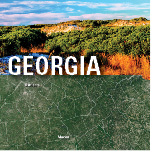
See Georgia from Space
See Georgia from Space
Use the links below to explore more Landsat resources highlighting Georgia.
Detailed Description
Georgia’s nickname is “The Peach State” for its fruitful production, but it also could be called “The State of Abundance.” Georgia ranks in the top 10 States for population, at more than 10 million residents, and 6 million residents are in the greater Atlanta area. Georgia also ranks in the top 10 States for forest areas with 24 million acres, or about two-thirds of the State. Its trees vary from deciduous hardwoods and pines to cypress and magnolias.
Georgia has diverse ecosystems, from the Blue Ridge Mountains in the northeast to the hilly, populous Piedmont region in the middle to the vast Coastal Plains that cover the southern half of the State with farms, forests, and wetlands. The State’s 14 major river basins, including the Chattahoochee and the Savannah, ultimately drain to the Atlantic Ocean or the Gulf of America. Millions of acres of wetlands include floodplain wetlands, freshwater swamps such as the Okefenokee Swamp, and coastal marshes. More than a dozen barrier islands lie off Georgia’s coastline. Wildlife in these myriad habitats include black bears, alligators, armadillos, manatees, sea turtles, and more than 40 species of snakes.
The Landsat satellite imagery scale and its 50-year record of Earth observations make Landsat ideal for monitoring changes in these diverse environments and supporting decision-making by government officials and land managers. Here are several ways Landsat has benefited Georgia.
Visit Landsat Benefits, State By State to learn more about how Landsat brings science to your state.
Sources/Usage
Public Domain.
Related

Luminescence
A mesmerizing plume creates a paradox of light and dark, brilliant and murky. The dark water of the Suwannee River flows from the Okefenokee Swamp in southern Georgia to the Gulf of America in Florida. The river’s inky color comes from decaying vegetation at the river’s swampy source.
Related
Luminescence
A mesmerizing plume creates a paradox of light and dark, brilliant and murky. The dark water of the Suwannee River flows from the Okefenokee Swamp in southern Georgia to the Gulf of America in Florida. The river’s inky color comes from decaying vegetation at the river’s swampy source.
A mesmerizing plume creates a paradox of light and dark, brilliant and murky. The dark water of the Suwannee River flows from the Okefenokee Swamp in southern Georgia to the Gulf of America in Florida. The river’s inky color comes from decaying vegetation at the river’s swampy source.