
Artificial Intelligence in the USGS Ecosystems Mission Area: Fish and Wildlife
USGS Ecosystems Mission Area (EMA) scientists are developing and testing artificial intelligence (AI) techniques, including machine learning and neural networks, to streamline the processing of images, videos, and audio recordings to provide critical information on species presence, abundance, and habitat use. AI is also improving USGS EMA's ability to detect wildlife disease, monitor and assess fish and wildlife populations, understand animal behavior and movement, and efficiently share critical information with partners and communities.
Using Artificial Intelligence to Improve Wildlife Detection and Identification
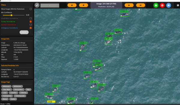
USGS EMA scientists are using AI techniques to automatically detect, count, classify, and annotate waterfowl, seabirds, and marine mammals in open water environments.
USGS EMA is using existing AI technology to set up processing routines to review weir video data in the Klamath River Basin, which includes training AI software to distinguish between common fish species (Coho, Chinook, and Steelhead) and applying AI to new footage to identify fish by species. This will inform the development and maintenance of a basin-wide fish tagging database. AI is also being applied to TroutSpotter, a new platform that uses AI to identify unique spot patterns on individual fish.
USGS EMA scientists are collaborating with mammal researchers at Colorado Parks and Wildlife to develop a machine learning model and workflow that can help assess species distribution and population dynamics using data from digital imagery.

Streamlining Wildlife Disease Surveillance with Artificial Intelligence
USGS EMA is also applying AI and machine learning approaches to create near real-time predictive maps of the movements of select waterfowl species known to transmit influenza A virus (IAV). Through an interactive web visualization tool, the maps will be publicly available and will allow the user to enter a location of interest and visualize current and recent migratory bird movements in the vicinity of that location based on an underlying model with assumptions.

Efficiently Monitoring Species Populations with Artificial Intelligence
Artificial intelligence has been used to better understand animal behavior and movement. For example, in the Kuparuk and Milne Point oil fields on the North Slope of Alaska, USGS EMA used a machine learning (random forest classification) approach to model traffic volume, which was then paired to caribou movement data to examine the animal’s behavioral responses to vehicle traffic.
Machine learning techniques are being used by USGS EMA scientists to inform box turtle capture-recapture methods to guide management actions by USFWS and NPS and have been incorporated into multi-scale population viability analysis linking population trends to management-relevant habitat characteristics and disturbances for greater sage grouse and mule deer.

USGS Ecosystems Mission Area (EMA) scientists are developing and testing artificial intelligence (AI) techniques, including machine learning and neural networks, to streamline the processing of images, videos, and audio recordings to provide critical information on species presence, abundance, and habitat use. AI is also improving USGS EMA's ability to detect wildlife disease, monitor and assess fish and wildlife populations, understand animal behavior and movement, and efficiently share critical information with partners and communities.
Using Artificial Intelligence to Improve Wildlife Detection and Identification
USGS EMA scientists are using AI techniques to automatically detect, count, classify, and annotate waterfowl, seabirds, and marine mammals in open water environments.
USGS EMA is using existing AI technology to set up processing routines to review weir video data in the Klamath River Basin, which includes training AI software to distinguish between common fish species (Coho, Chinook, and Steelhead) and applying AI to new footage to identify fish by species. This will inform the development and maintenance of a basin-wide fish tagging database. AI is also being applied to TroutSpotter, a new platform that uses AI to identify unique spot patterns on individual fish.
USGS EMA scientists are collaborating with mammal researchers at Colorado Parks and Wildlife to develop a machine learning model and workflow that can help assess species distribution and population dynamics using data from digital imagery.
Streamlining Wildlife Disease Surveillance with Artificial Intelligence
USGS EMA is also applying AI and machine learning approaches to create near real-time predictive maps of the movements of select waterfowl species known to transmit influenza A virus (IAV). Through an interactive web visualization tool, the maps will be publicly available and will allow the user to enter a location of interest and visualize current and recent migratory bird movements in the vicinity of that location based on an underlying model with assumptions.
Efficiently Monitoring Species Populations with Artificial Intelligence
Artificial intelligence has been used to better understand animal behavior and movement. For example, in the Kuparuk and Milne Point oil fields on the North Slope of Alaska, USGS EMA used a machine learning (random forest classification) approach to model traffic volume, which was then paired to caribou movement data to examine the animal’s behavioral responses to vehicle traffic.
Machine learning techniques are being used by USGS EMA scientists to inform box turtle capture-recapture methods to guide management actions by USFWS and NPS and have been incorporated into multi-scale population viability analysis linking population trends to management-relevant habitat characteristics and disturbances for greater sage grouse and mule deer.