
USGS Coastal Storm Projection Data Inform Department of Defense Infrastructure Risk Assessments
Using USGS data, the U.S. Department of Defense's (DoD) Regional Sea Level Database supports DoD efforts to assess and respond to coastal infrastructure exposures and vulnerabilities from plausible scenarios of future mean sea level and extreme, storm-driven water levels.
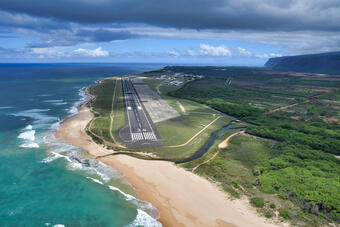
After analyzing existing databases available for use in the DoD Regional Sea Level Database, DoD ultimately chose the USGS Coastal Storm Modeling System (CoSMoS) data report for Hawai'i, which forecasts coastal flooding extents and depths based on possible future sea levels as well as wave-driven set-up and run-up due to projected future storms. As a result, these data will be the "go-to" information to guide DoD’s coastal infrastructure exposure and vulnerability assessments at their coastal bases in Hawai'i: Naval Base Pearl Harbor, Hickam Air Force Base, Marine Corps Base Hawai'i, and Pacific Missile Range Facility-Barking Sands.
“By modeling the flooding extents and depths for numerous return-period (e.g., 1-year, 20-year, and 100-year) storms in the CoSMoS system, we generate true risk-based information (multiple probabilities of occurrence based on storm return periods, in addition to magnitudes of impact based on flood extents and depths) that DoD, state, and local governments require for their risk valuation frameworks,” said USGS Research Geologist Curt Storlazzi, lead author of the data report. “Therefore, we are already meeting the goals of the March 2025 Executive Order on Achieving Efficiency Through State and Local Preparedness.”
This effort was jointly funded by the USGS Pacific Islands Climate Adaptation Science Center and the USGS Coastal and Marine Hazards and Resources Program.
Related

Coastal Storm Modeling System (CoSMoS)
Related