
A landslide above the toe of the South Sawyer Glacier failed into the waters of Tracy Arm, south of Juneau, Alaska, producing a tsunami on Sunday, August 10th, 2025, at 05:26 AKDT / 13:26 UTC. No injuries or fatalities have been reported. This page may be updated as more information about the event is obtained.
Steep, mountainous landslide areas are inherently unstable and will continue to change for years following an initial landslide. Continued rockfall and smaller-scale landslide events from the exposed landslide scar are expected and could impact the water, potentially causing future local tsunami. As such, this area remains hazardous.
This landslide event page serves as an event summary to communicate timely science information to multiple audiences. This information includes what is currently understood about the event and ongoing activities of the USGS and partner agencies.
Geophysical data, satellite imagery, and field surveys provided the observations for the following summary.
Updates | Field Photos | Background | More Information
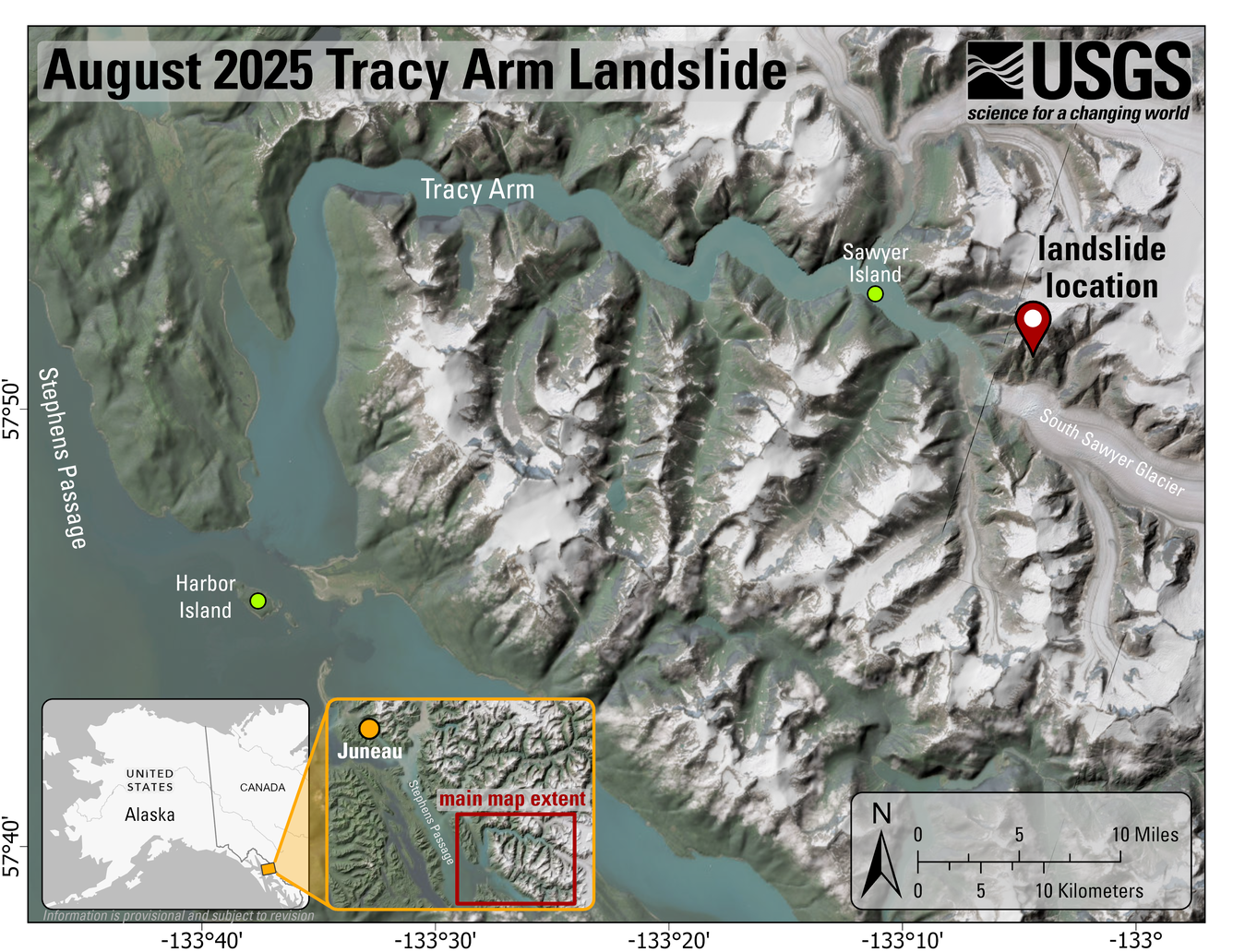
In the early morning of August 10th, 2025, a landslide occurred in Tracy Arm, Alaska, about 80 miles (130 km) south-southeast of Juneau. The landslide generated a tsunami in the fiord. The Alaska Earthquake Center first detected this event, noting seismic waves indicative of a landslide occurring at about 05:30 AM local time1. Kayakers camped on Harbor Island, located at the mouth of Tracy Arm, reported their gear being swept away by a wave2. Preliminary interpretation of photos taken by kayakers in the area indicates that the landslide generated a tsunami at least 30 meters (approximately 100 ft) high at Sawyer Island, a small island located where the fiords containing South Sawyer and North Sawyer glaciers meet2. The tsunami was also recorded far from the landslide on a NOAA coastal tide gauge in Juneau. The National Tsunami Warning Center reported that the maximum tsunami wave height at the gauge was 36 cm (approximately 14 in) above the tide, and that the waves continued for hours.
Field Photos
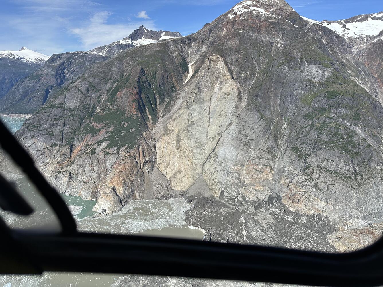

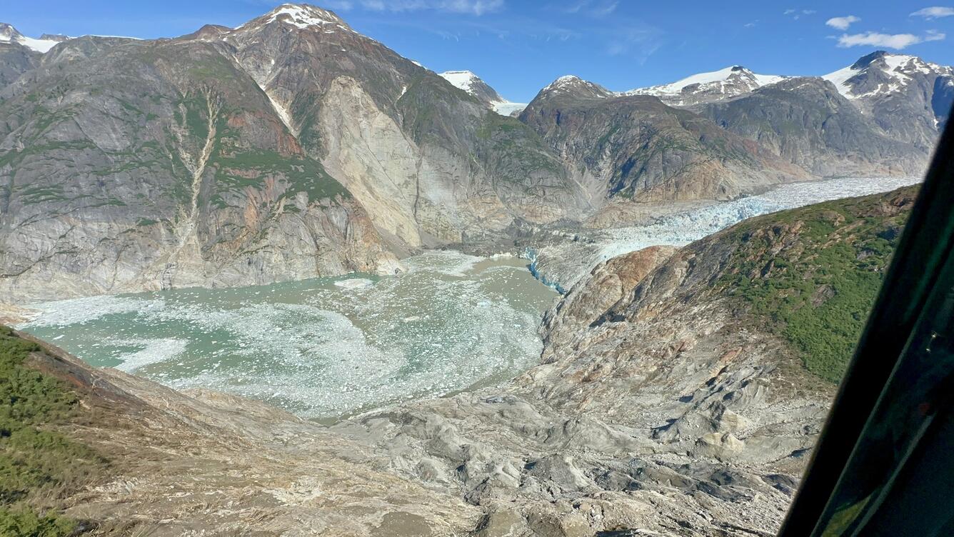
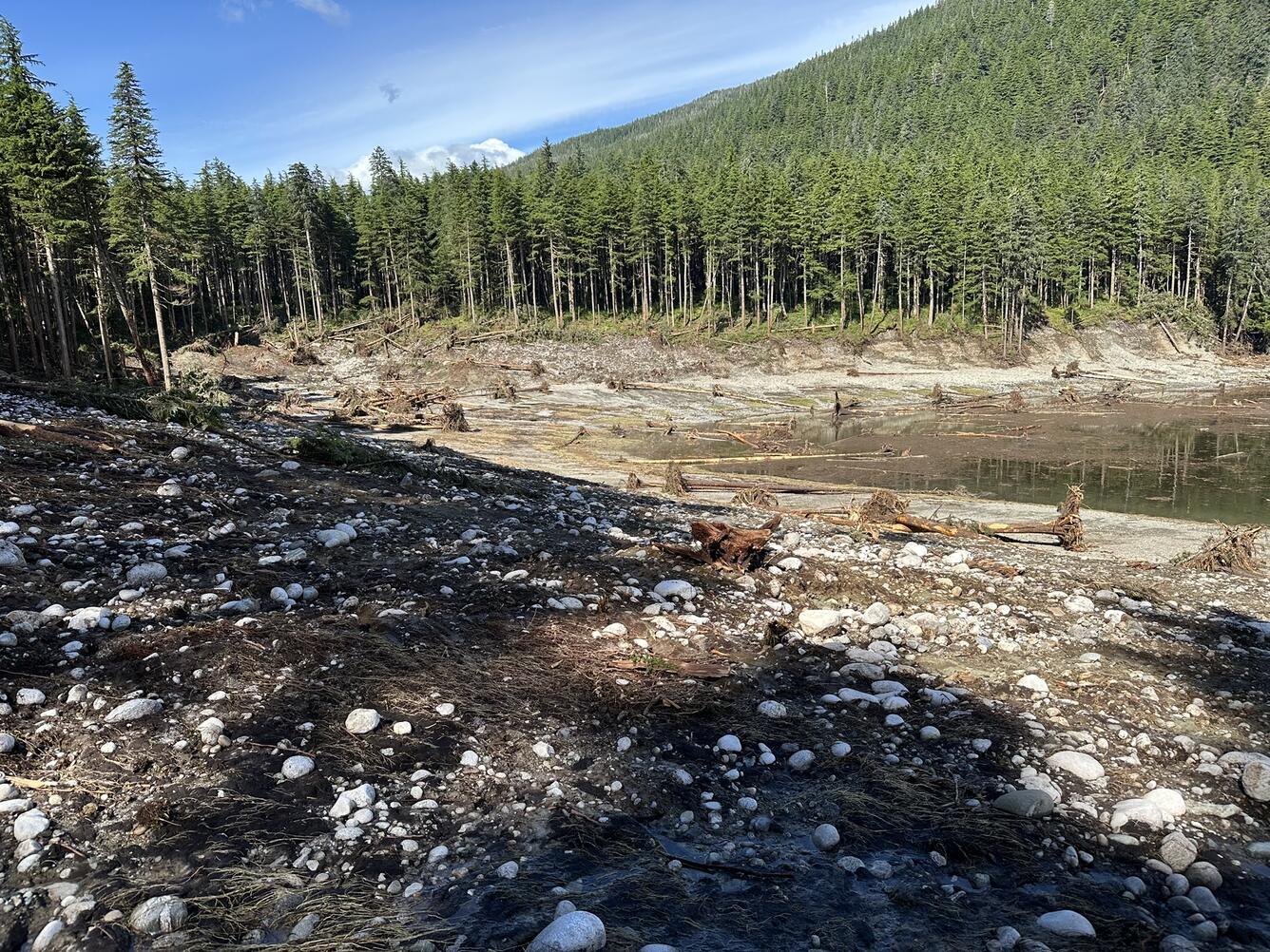
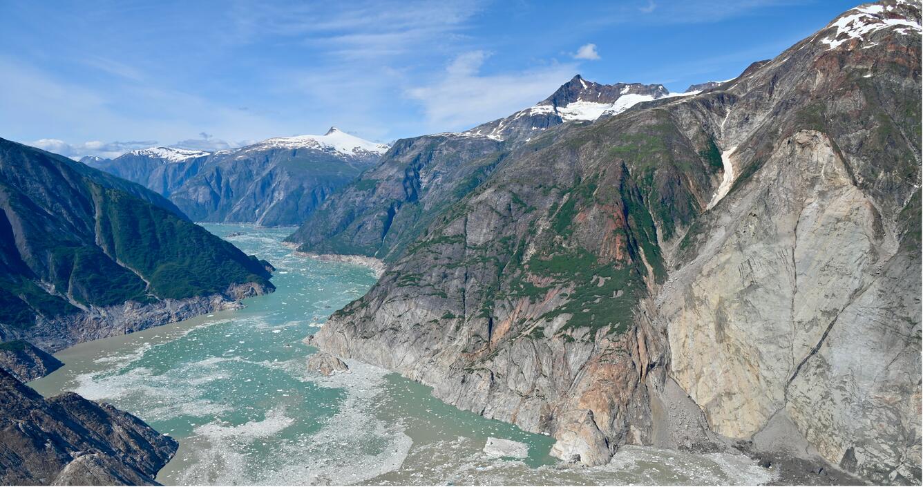
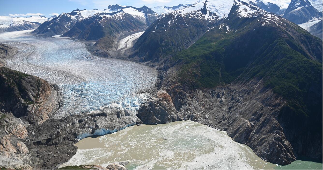
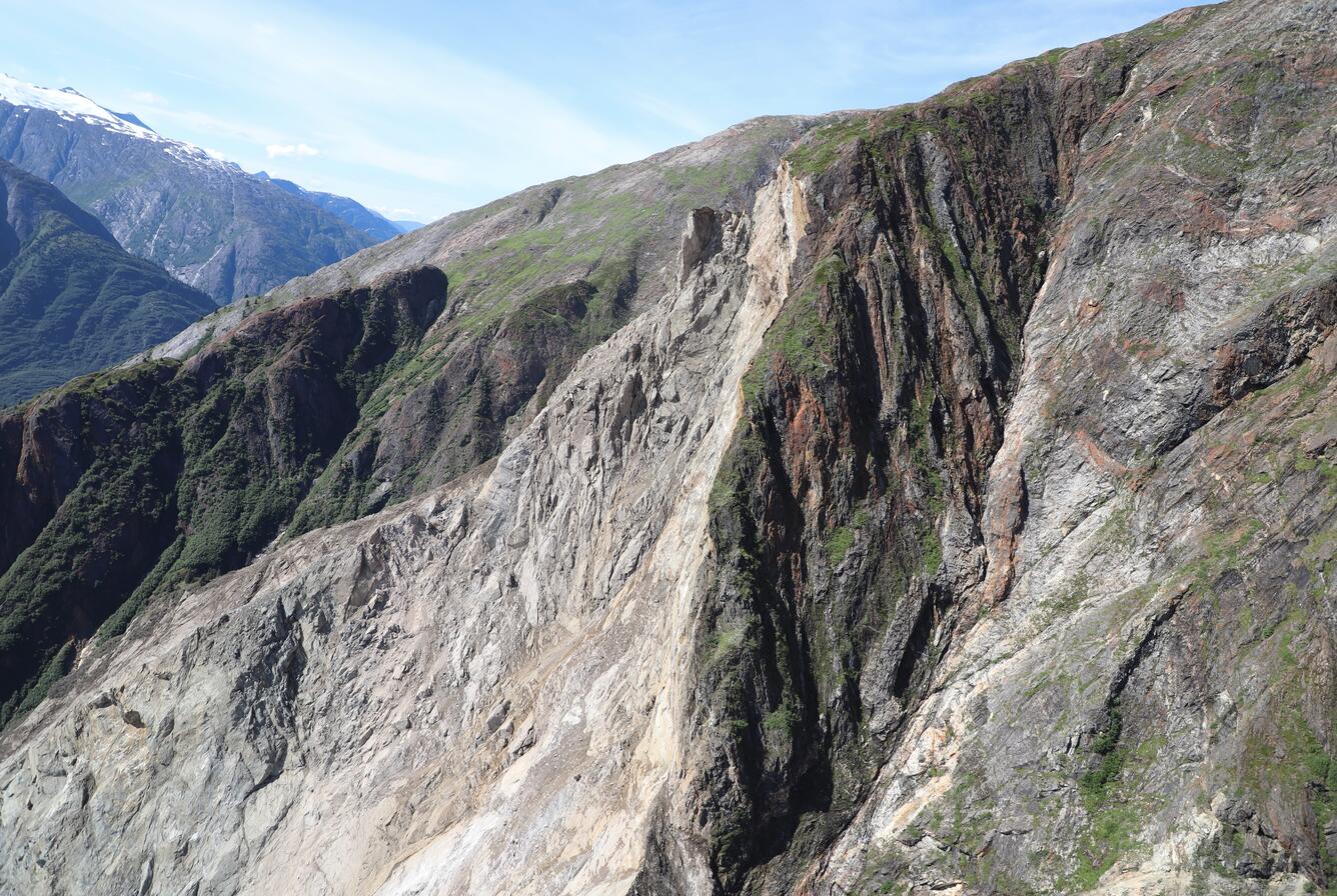
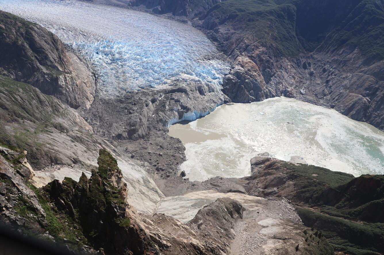
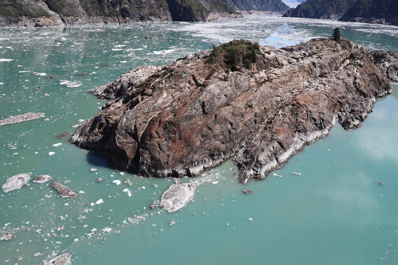
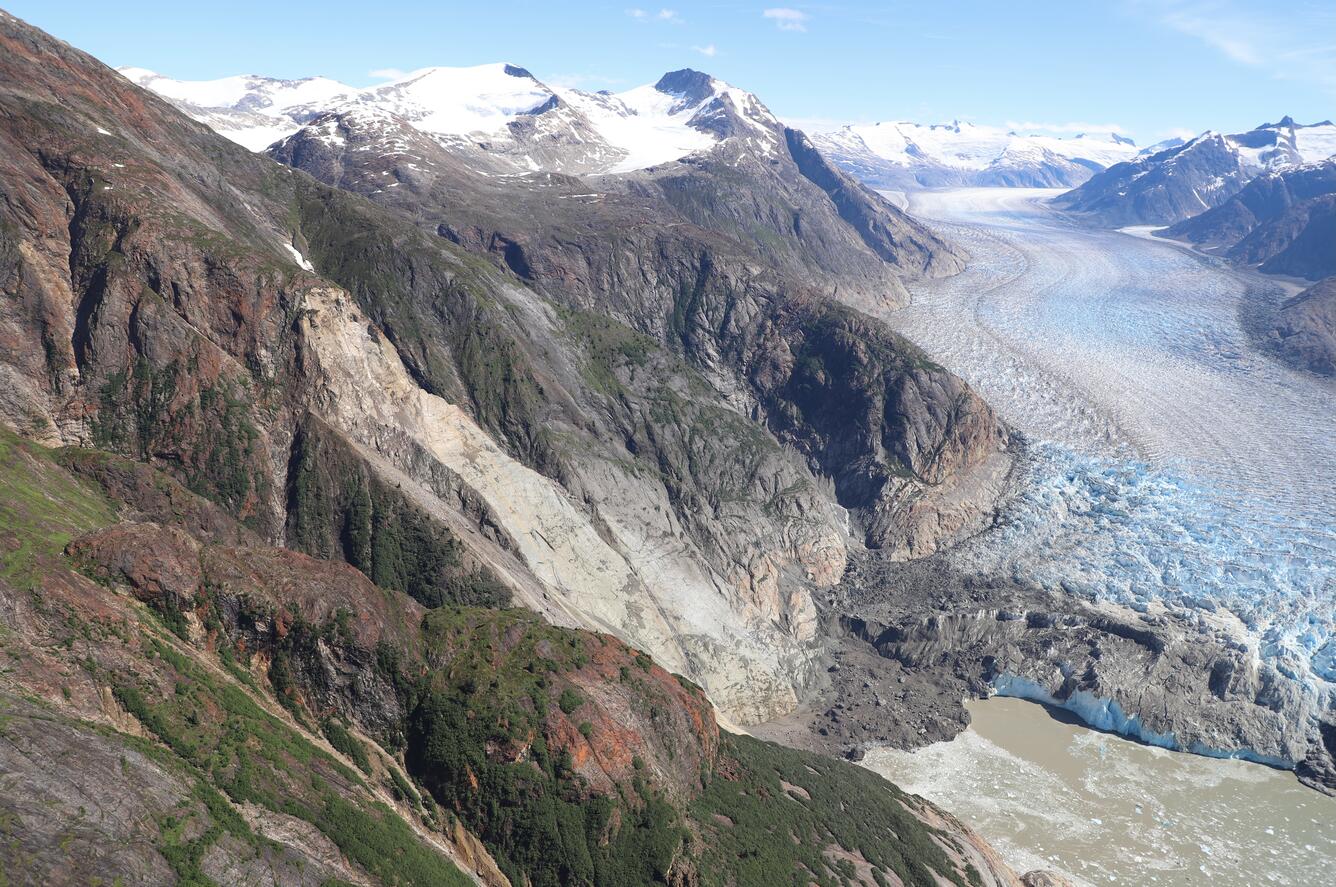
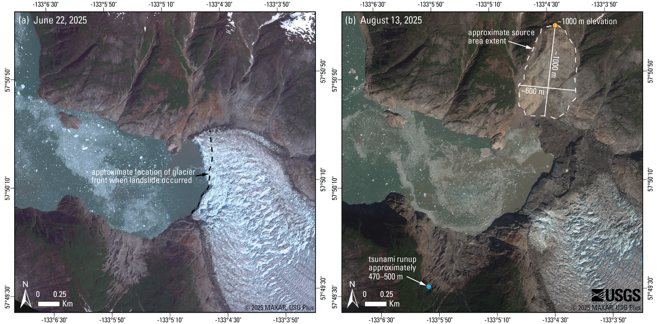
A satellite image acquired on Wednesday, August 13th clearly shows the landslide location on the north side of the fiord containing South Sawyer glacier. Some or most of the material appears to have directly entered the water adjacent to the terminus of the glacier. Preliminary estimates indicate a volume of up to ~100 million cubic meters (~130 million cubic yards). On Wednesday, August 13th, USGS personnel conducted a helicopter-borne aerial survey of the area, capturing photos. Satellite and digital elevation model analysis indicate a runup height of 470–500 m (1500–1600 ft) opposite the landslide. Runup heights reported here are preliminary and are subject to change with additional field validation.
Landslides that form above, and which could fail into water bodies including lakes, fiords, and bays, are relatively common in the steep and glaciated mountains of Alaska3,4,5. The 1958 Lituya Bay landslide-generated tsunami had a peak runup of 530 m (~1,740 ft)6. In 2015, a large landslide in Taan Fiord generated a tsunami with runup directly across from the landslide exceeding 190 m (620 ft)7. Most recently, in August 2024 a landslide produced a tsunami 17 m (56 ft) high in Pedersen Lagoon8.
Contributors to this page include Liam Toney (USGS), Erin Jensen (USGS), Eric Bilderback (USGS), Marísa Macías (USGS), Sonia Ellison (USGS), Ezgi Karasözen (AEC), Dennis Staley (USGS), John Lyons (USGS), and Cyrus Read (USGS).
View the aerial and videography data release on ScienceBase.
View the Alaska Earthquake Center’s information page for this landslide.
View the USGS National Earthquake Information Center event page for this landslide.
Learn more about the USGS Landslide Hazards Program.
Learn more about USGS Landslide Response.
References
1 Alaska Earthquake Center, 2025, Local tsunami and landslide event in Endicott Arm, Southeast Alaska [X post], posted August 10, 2025, at https://x.com/AKearthquake/status/1954654898920038764
2 Alaska Earthquake Center, 2025, Major landslide in Southeast Alaska fjord: Alaska Earthquake Center, posted August 12, 2025, accessed August 12, 2025, at https://earthquake.alaska.edu/major-landslide-southeast-alaska-fjord
3 Miller, D.J, 1960, The Alaska earthquake of July 10, 1958: Giant wave in Lituya Bay: Bulletin of the Seismological Society of America 50(2): 253-266. https://doi.org/10.1785/BSSA0500020253
4 Coe, J.A., Bessette-Kirton, E.K., and Geertsema, M., 2018, Increasing rock-avalanche size and mobility in Glacier Bay National Park and Preserve, Alaska detected from 1984 to 2016 Landsat imagery: Landslides 15, 393–407, https://doi.org/10.1007/s10346-017-0879-7
5 Schaefer, L.N., Kim, J., Staley, D.M., Lu, Z., and Barnhart, K.R., 2024, Satellite interferometry landslide detection and preliminary tsunamigenic plausibility assessment in Prince William Sound, southcentral Alaska: U.S. Geological Survey Open-File Report 2023–1099, 22 p., https://doi.org/10.3133/ofr20231099
6 Miller, D. J., 1960, Giant waves in Lituya Bay, Alaska: U.S. Geological Survey Professional Paper 354-C, p. 86 p., accessed August 14, 2025, at https://pubs.usgs.gov/pp/0354c/report.pdf
7 Higman, B., Shugar, D. H., Stark, C. P., Ekström, G., Koppes, M. N., Lynett, P., Dufresne, A., Haeussler, P. J., Geertsema, M., Gulick, S., Mattox, A., Venditti, J. G., Walton, M. A. L., McCall, N., Mckittrick, E., MacInnes, B., Bilderback, E. L., Tang, H., Willis, M. J., Richmond, B., Reece, R. S., Larsen, C., Olson, B., Capra, J., Ayca, A., Bloom, C., Williams, H., Bonno, D., Weiss, R., Keen, A., Skanavis, V., and Loso, M., 2018, The 2015 landslide and tsunami in Taan Fiord, Alaska: Scientific reports, v. 8, n. 1, p. 12993, https://doi.org/10.1038/s41598-018-30475-w
8 U.S. Geological Survey, 2024, 2024 Pedersen Lagoon landslide-generated tsunami: U.S. Geological Survey Landslide Hazards Program, accessed August 11, 2025, at https://www.usgs.gov/programs/landslide-hazards/science/2024-pedersen-lagoon-landslide-generated-tsunami
| Disclaimer: This information is preliminary or provisional and is subject to revision. It is being provided to meet the need for timely science to assess ongoing hazards. The information has not received final approval by the U.S. Geological Survey (USGS) and is provided on the condition that neither the USGS nor the U.S. Government shall be held liable for any damages resulting from the authorized or unauthorized use of the information. |
A landslide above the toe of the South Sawyer Glacier failed into the waters of Tracy Arm, south of Juneau, Alaska, producing a tsunami on Sunday, August 10th, 2025, at 05:26 AKDT / 13:26 UTC. No injuries or fatalities have been reported. This page may be updated as more information about the event is obtained.
Steep, mountainous landslide areas are inherently unstable and will continue to change for years following an initial landslide. Continued rockfall and smaller-scale landslide events from the exposed landslide scar are expected and could impact the water, potentially causing future local tsunami. As such, this area remains hazardous.
This landslide event page serves as an event summary to communicate timely science information to multiple audiences. This information includes what is currently understood about the event and ongoing activities of the USGS and partner agencies.
Geophysical data, satellite imagery, and field surveys provided the observations for the following summary.
Updates | Field Photos | Background | More Information
In the early morning of August 10th, 2025, a landslide occurred in Tracy Arm, Alaska, about 80 miles (130 km) south-southeast of Juneau. The landslide generated a tsunami in the fiord. The Alaska Earthquake Center first detected this event, noting seismic waves indicative of a landslide occurring at about 05:30 AM local time1. Kayakers camped on Harbor Island, located at the mouth of Tracy Arm, reported their gear being swept away by a wave2. Preliminary interpretation of photos taken by kayakers in the area indicates that the landslide generated a tsunami at least 30 meters (approximately 100 ft) high at Sawyer Island, a small island located where the fiords containing South Sawyer and North Sawyer glaciers meet2. The tsunami was also recorded far from the landslide on a NOAA coastal tide gauge in Juneau. The National Tsunami Warning Center reported that the maximum tsunami wave height at the gauge was 36 cm (approximately 14 in) above the tide, and that the waves continued for hours.
Field Photos
A satellite image acquired on Wednesday, August 13th clearly shows the landslide location on the north side of the fiord containing South Sawyer glacier. Some or most of the material appears to have directly entered the water adjacent to the terminus of the glacier. Preliminary estimates indicate a volume of up to ~100 million cubic meters (~130 million cubic yards). On Wednesday, August 13th, USGS personnel conducted a helicopter-borne aerial survey of the area, capturing photos. Satellite and digital elevation model analysis indicate a runup height of 470–500 m (1500–1600 ft) opposite the landslide. Runup heights reported here are preliminary and are subject to change with additional field validation.
Landslides that form above, and which could fail into water bodies including lakes, fiords, and bays, are relatively common in the steep and glaciated mountains of Alaska3,4,5. The 1958 Lituya Bay landslide-generated tsunami had a peak runup of 530 m (~1,740 ft)6. In 2015, a large landslide in Taan Fiord generated a tsunami with runup directly across from the landslide exceeding 190 m (620 ft)7. Most recently, in August 2024 a landslide produced a tsunami 17 m (56 ft) high in Pedersen Lagoon8.
Contributors to this page include Liam Toney (USGS), Erin Jensen (USGS), Eric Bilderback (USGS), Marísa Macías (USGS), Sonia Ellison (USGS), Ezgi Karasözen (AEC), Dennis Staley (USGS), John Lyons (USGS), and Cyrus Read (USGS).
View the aerial and videography data release on ScienceBase.
View the Alaska Earthquake Center’s information page for this landslide.
View the USGS National Earthquake Information Center event page for this landslide.
Learn more about the USGS Landslide Hazards Program.
Learn more about USGS Landslide Response.
References
1 Alaska Earthquake Center, 2025, Local tsunami and landslide event in Endicott Arm, Southeast Alaska [X post], posted August 10, 2025, at https://x.com/AKearthquake/status/1954654898920038764
2 Alaska Earthquake Center, 2025, Major landslide in Southeast Alaska fjord: Alaska Earthquake Center, posted August 12, 2025, accessed August 12, 2025, at https://earthquake.alaska.edu/major-landslide-southeast-alaska-fjord
3 Miller, D.J, 1960, The Alaska earthquake of July 10, 1958: Giant wave in Lituya Bay: Bulletin of the Seismological Society of America 50(2): 253-266. https://doi.org/10.1785/BSSA0500020253
4 Coe, J.A., Bessette-Kirton, E.K., and Geertsema, M., 2018, Increasing rock-avalanche size and mobility in Glacier Bay National Park and Preserve, Alaska detected from 1984 to 2016 Landsat imagery: Landslides 15, 393–407, https://doi.org/10.1007/s10346-017-0879-7
5 Schaefer, L.N., Kim, J., Staley, D.M., Lu, Z., and Barnhart, K.R., 2024, Satellite interferometry landslide detection and preliminary tsunamigenic plausibility assessment in Prince William Sound, southcentral Alaska: U.S. Geological Survey Open-File Report 2023–1099, 22 p., https://doi.org/10.3133/ofr20231099
6 Miller, D. J., 1960, Giant waves in Lituya Bay, Alaska: U.S. Geological Survey Professional Paper 354-C, p. 86 p., accessed August 14, 2025, at https://pubs.usgs.gov/pp/0354c/report.pdf
7 Higman, B., Shugar, D. H., Stark, C. P., Ekström, G., Koppes, M. N., Lynett, P., Dufresne, A., Haeussler, P. J., Geertsema, M., Gulick, S., Mattox, A., Venditti, J. G., Walton, M. A. L., McCall, N., Mckittrick, E., MacInnes, B., Bilderback, E. L., Tang, H., Willis, M. J., Richmond, B., Reece, R. S., Larsen, C., Olson, B., Capra, J., Ayca, A., Bloom, C., Williams, H., Bonno, D., Weiss, R., Keen, A., Skanavis, V., and Loso, M., 2018, The 2015 landslide and tsunami in Taan Fiord, Alaska: Scientific reports, v. 8, n. 1, p. 12993, https://doi.org/10.1038/s41598-018-30475-w
8 U.S. Geological Survey, 2024, 2024 Pedersen Lagoon landslide-generated tsunami: U.S. Geological Survey Landslide Hazards Program, accessed August 11, 2025, at https://www.usgs.gov/programs/landslide-hazards/science/2024-pedersen-lagoon-landslide-generated-tsunami
| Disclaimer: This information is preliminary or provisional and is subject to revision. It is being provided to meet the need for timely science to assess ongoing hazards. The information has not received final approval by the U.S. Geological Survey (USGS) and is provided on the condition that neither the USGS nor the U.S. Government shall be held liable for any damages resulting from the authorized or unauthorized use of the information. |