
Latest in Landsat December 2024 - Vol. 3 | Issue 12
Celebrating Earth Remote Sensing Excellence
William T. Pecora Awards presented at recent AGU meeting
Jack A. Kaye was presented the individual award in recognition of his extraordinary contributions in shaping, championing, and sustaining multidisciplinary Earth science to improve understanding of Earth as an integrated system.
The Optical Oceanography Lab of the University of South Florida received the group award for groundbreaking advancements in remote sensing technology to improve the understanding of changing aquatic ecosystems, and strong commitment to translating findings into tangible benefits for society.
The awards were presented at the American Geophysical Union (AGU) annual meeting on December 10, 2024, in Washington, D.C. You can read the entire article to learn more about the award recipients on this USGS News release.
The William T. Pecora Awards are presented annually to individuals and groups who show innovations in remote sensing to advance and improve understanding of Earth science through space-based satellite observations.
Do you know how to cite Landsat Products?
Landsat products and images created from Landsat data are in the public domain and may be used without any restrictions — however, it is always good to provide a citation to ensure scientific transparency and reproducibility to help track product and/or image impact.

Citation statements for Landsat products are now visible at the top of each product-specific webpage. These webpages are linked from the main Landsat Collection 2 webpage.
The citations for the Landsat Level-2 Surface Reflectance products are listed below to serve as an example of how they are formatted.
There are no restrictions on the use of Landsat products. Please cite the appropriate Landsat Level-2 datasets in the following manner:
- Earth Resources Observation and Science (EROS) Center. (2020). Landsat 8-9 Operational Land Imager / Thermal Infrared Sensor Level-2, Collection 2 [dataset]. U.S. Geological Survey. https://doi.org/10.5066/P9OGBGM6.
- Earth Resources Observation and Science (EROS) Center. (2020). Landsat 7 Enhanced Thematic Mapper Plus Level-2, Collection 2 [dataset]. U.S. Geological Survey. https://doi.org/10.5066/P9C7I13B.
- Earth Resources Observation and Science (EROS) Center. (2020). Landsat 4-5 Thematic Mapper Level-2, Collection 2 [dataset]. U.S. Geological Survey. https://doi.org/10.5066/P9IAXOVV.
When you use Landsat images for outreach, publication, or social media purposes, the following credit can be used to acknowledge the USGS: Landsat Collection 2 Level-2 image courtesy of the U.S. Geological Survey
Please contact USGS EROS User Services with any questions you may have about citing Landsat products and images.
New Landsat Calibration Fact Sheet Available
The USGS EROS Calibration and Validation (Cal/Val) Center of Excellence (ECCOE) team has prepared a newly published fact sheet describing how geometric and radiometric calibration and characterization ensures that Landsat data are of highest quality. The accuracy of the ECCOE team calibration adjustments gives other civil and commercial satellite programs around the globe a trusted criterion and reference point.
-
Landsat geometric and radiometric calibration and characterization Landsat geometric and radiometric calibration and characterization
The U.S. Geological Survey (USGS) Earth Resources Observation and Science Calibration and Validation (Cal/Val) Center of Excellence (ECCOE) focuses on improving the accuracy, precision, calibration, and product quality of remote-sensing data, leveraging years of multiscale optical system geometric and radiometric calibration and characterization experience. The ECCOE Landsat Cal/Val team
ICYMI: New Annual NLCD Webinar Recording Now Available
Products based on Landsat data provide timely, long-term, and detailed land surface change information
Podcasts & Videos

Eyes on Earth Episode 127 – The Historic Landsat 7 Mission
In this episode of Eyes on Earth, we talk about the incredible career of Landsat 7, which collected science imagery of the Earth for nearly 25 years. The Flight Operations Team at NASA Goddard Space Flight Center and engineers at EROS work together to collect imagery, send commands to the satellite, and keep it healthy. After over 133,000 orbits and 3.3 million images collected, Landsat 7 stopped…

The Eye of Quebec (Image of the Week)
A large, round lake in Quebec, Canada, highlights the geography of an ancient impact crater.In the late Triassic Period, a 3 mile wide meteorite struck northern Pangea at over 30,000 miles per hour.The resulting crater is now 214 million years old, but the dramatic circular lake visible in 2024 Landsat imagery is a surprisingly recent feature.It was the completion of the Daniel-Johnson Dam in…

Eyes on Earth Episode 128 – 2024 EROS Fall Poster Session
In this episode of Eyes on Earth, we mingle at the 2024 EROS Fall Poster Session. A poster session is essentially a way for scientists to share their work with their colleagues in a public forum. About 30 posters were on display in the EROS atrium from EROS staff and several students from South Dakota State University and the University of South Dakota. We talked to a few of them to get quick…
November Image Showcase
A number of dramatic images were recently posted to the Landsat Missions Web Site and Landsat social media channels. Below, we highlight just a few.
Happy Thanksgiving in the United States

The origins of Thanksgiving are often traced back to the 1621 autumn harvest feast shared by the English colonists and the Wampanoag people, a group of Indigenous tribes who inhabited, and continue to inhabit, parts of present-day Massachusetts and Rhode Island.
The event, held on the land now known as Plymouth, was a celebration of the Pilgrim's first successful harvest after a harsh New England winter. The Wampanoag people played a crucial role in the Pilgrims' survival by sharing their knowledge of the land and resources.
Throughout the centuries, Thanksgiving has become a cornerstone of American tradition and evolved into a day of celebration, joy, and gratitude. However, it is also an important time to honor and recognize the Indigenous lands on which we live and the people who call these lands home.
This image can be viewed larger at https://www.usgs.gov/media/images/landsat-8-image-massachusetts-coast.
The Henry Mountains - a history lesson back to 1877

The Henry Mountains, a remote and rugged range in southeastern Utah situated between Capitol Reef National Park and Glen Canyon National Recreation Area, hold a unique distinction in American history. They were one of the last mountain ranges in the lower 48 states to be named, explored, and mapped.
John Wesley Powell made note of the landform in 1869 during one of his expeditions and referred to them as the “Unknown” Mountains. It wasn’t until 1872 that the range was named after Joseph Henry, a great American scientist and the first Secretary of the Smithsonian Institution.
Even then, no surveys were made until 1875 and 1876, when geologist Grove Karl Gilbert and topographer Walter Graves visited them for that purpose. In their 1877 report titled "Geology of the Henry Mountains", they provided a detailed account about the structure of the area overall, specific features about each mountain in the range, and their studies about potential erosion and water quality effects.
The interesting read is available to download from https://pubs.usgs.gov/publication/70039916.
Celebrating GIS Day with Landsat

GIS Day, celebrated each year on November 19th, highlights the power of geographic information systems in addressing global challenges and supporting communities and industries throughout the world. Landsat, a pioneer of Earth observation, launched the era of satellite remote sensing and has played a pivotal role in the evolution of GIS.
By providing a continuous stream of data since 1972, Landsat has been instrumental in mapping land change, monitoring disasters, and assessing environmental impacts. GIS Day provides an extra opportunity to recognize the invaluable contributions of Landsat and other remote sensing technologies.
Learn more about how Landsat launched the era of remote sensing here: https://www.usgs.gov/landsat-legacy/fifty-years-exploration-and-innovation-how-landsat-launched-remote-sensing-era.
Pampanga River Delta, Philippines
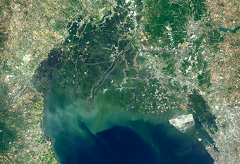
The Pampanga River, located in the Philippines, is the second longest river on the island of Luzon and its river basin is the fourth largest in the country. The catchment area is greater than 10,000 square kilometers (4,000 square miles) and covers all or portions of five provinces. The Pampanga River branches into several waterways that form a vast, intricate, and fertile delta.
The Pampanga River Delta is home to several aquaculture farming systems and plays a key role in the socioeconomic activities in the country.
This image can be viewed larger at https://www.usgs.gov/media/images/pampanga-river-delta.
Do you have questions about Landsat?
-

Connect Connect
Explore the Landsat social media channels, discover the latest news and resources, and find answers to your questions about Landsat Missions, science products, and data access. We are here to help you stay informed!