
Latest in Landsat January 2025 - Vol. 4 | Issue 1

A 2024 year-end story highlights newly released land cover products, numerous science study contributions, renewed partnerships, and reports that express how Landsat's 50+ years of Earth observation capability remains a steadfast vital resource for monitoring changes in the world’s land masses and water resources.
Scroll down to see a few of the highlights included in the year end summary, and check out the full story here:
2024 in Review: Highlighting the Best of Landsat

Landsat’s Economic Value increases to $25.6 Billion in 2023
A new report about the Landsat satellite program – a partnership between the U.S. Geological Survey and National Aeronautics and Space Administration – calculates its 2023 value at \$25.6 billion—a marked increase from its 2017 estimate of \$3.45 billion.

LEAP: Landsat Extended Acquisitions of the Poles Imaging Plan
Landsat Extended Acquisitions of the Poles (LEAP) imaging plan is a Landsat special request data collection program for Earth's polar regions that include Antarctica, Greenland, and Arctic sea ice geographies. The LEAP program includes Landsat 8 and Landsat 9 observatories that operationally acquire spaceborne images of all Earth's land surface and near-shore coastal environments. These...

USGS Reinvents Widely Used NLCD
On your next drive, really look at what covers the landscape: Sprawling housing developments? Crowded skyscrapers? Parking lots? Farm fields? Forests? Rivers?The USGS has led the way in accurately mapping this land cover across the country with the National Land Cover Database (NLCD) for more than two decades. Now NLCD debuts big improvements under a new name: Annual NLCD.
Don't miss these interesting articles!
-
USGS-NASA Award Honors Excellence in Earth Observation USGS-NASA Award Honors Excellence in Earth Observation
The United States Geological Survey (USGS) and National Aeronautics and Space Administration (NASA) recognize the contributions of satellite or aerial remote sensing innovators with the presentation of the 51st annual William T. Pecora Award at the American Geophysical Union (AGU) annual meeting, on December 10, 2024, in Washington, D.C.
-
-

Eyes on Earth Episode 129 – What Happens During a Landsat Pass?
In this episode of Eyes on Earth, we talk to ground station technicians to find out how Landsat satellite data gets from the spacecraft to EROS and then to the archive. We see what it’s like in EROS’s Landsat operations room and what the technicians do before, during, and after a Landsat pass. The task of making sure those bits of data make their way to the archive so it can be used for land...
-
-

Landsat Reprocessing Events Landsat Reprocessing Events
The USGS consistently delivers high quality Landsat products suitable for science research and analysis. On occasion, Landsat data may need to be reprocessed. To best support your research and ensure you are using the most recent data, the Landsat Processing Events application allows you to search and locate Landsat products that have been reprocessed.
-

JACIE 2025 Workshop JACIE 2025 Workshop
The Joint Agency Commercial Imagery Evaluation (JACIE) 2025 Workshop April 7-11, 2025 — USGS Headquarters, Reston, Virginia USA JACIE 2025 continues a long-standing tradition of bringing together federal agencies, industry partners, and researchers to assess and enhance the capabilities, quality, and calibration of remote sensing imagery.
Are you ready to unwind, relax, and explore the Earth?
Our latest video features a full hour of mesmerizing Landsat images that take you on a peaceful journey of the world. This virtual tour showcases our planet’s diverse landscapes, from the icy expanses of Antarctica, Greenland, and Russia to the arid deserts of Namibia, Pakistan, and Australia. This unique blend of science and serenity offers a calming, immersive experience!
-
-
")
1 HOUR Relaxing Satellite Imagery (Sleep Music, Landsat, Concentrate, Meditation)
Landsat satellites capture images of the Earth’s surface. While the sensors aboard Landsat capture a wide range of scientifically useful wavelengths, this collection reveals natural color imagery in the red, green and blue parts of the visible spectrum, as if viewed by the naked eye from 438 miles above the surface. Scenes like these help scientists and communities around the world study our...
-
Snowy Landsat images
The striking images here display the high contrast between the snow covered areas and surrounding features. The reflective nature of snow allows us to see it as bright shades of white.
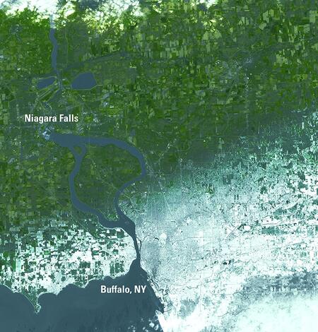
Landsat 8 image of western NY area after December snowfall
On December 12, 2024, heavy lake effect snow blanketed the Buffalo, New York metro area with over 2 feet accumulating in less than 24 hours. This area normally receives heavy snowfall each year during the Northern Hemisphere winter months due to being situated along the shore of Lake Erie. In this Landsat 8 image acquired on December 13th, it is easy to see where the snow fell, with the heavier…

Landsat Mosaic of the Wind River Range in Wyoming
The Wind River Range, located in west-central Wyoming, is a unique wilderness area that rises from the high plains of the South Pass of the Continental Divide and runs northwest to the Yellowstone Plateau. The Winds, as they are affectionately known, are exceptionally long, wide, high, rugged, and remote. They are the highest range in the Rocky Mountains outside of Colorado and contain more than…

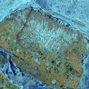
Landsat 9 Image of China-Mongolia Border
Landsat 9 image of the China-Mongolia border, showing parts of the autonomous region of Xinjiang, China, and Khovd Province, Mongolia.Image date: October 23, 2024Path 141, Row 28A recent Landsat 9 image of eastern China and western Mongolia bears a striking resemblance to a majestic snow-flocked balsam fir. This festive scene depicts the most southerly reaches of the Altai Mountains, the Bulgan…
Do you have questions about Landsat? Check these out!
-

Landsat Frequently Asked Questions Landsat Frequently Asked Questions
This page lists commonly asked questions pertaining to the Landsat satellite missions, the science behind maintaining high quality Landsat data, and what products are available - and how to download them.
-

Connect Connect
Explore the Landsat social media channels, discover the latest news and resources, and find answers to your questions about Landsat Missions, science products, and data access. We are here to help you stay informed!