An official website of the United States government
Here's how you know
Official websites use .gov
A .gov website belongs to an official government organization in the United States.
Secure .gov websites use HTTPS
A lock () or https:// means you’ve safely connected to the .gov website. Share sensitive information only on official, secure websites.
On your next drive, really look at what covers the landscape: Sprawling housing developments? Crowded skyscrapers? Parking lots? Farm fields? Forests? Rivers?
The USGS has led the way in accurately mapping this land cover across the country with the National Land Cover Database (NLCD) for more than two decades. Now NLCD debuts big improvements under a new name: Annual NLCD.
Annual NLCD arrived October 24, 2024, with a new ability to look at land cover and land change year by year, and over a longer time span than previous versions: from 1985 to 2023.
Two years of effort went into the reinvention of a resource that’s widely used by federal agencies, state and local governments, researchers and many others. NLCD has contributed to a foundation of data essential for land monitoring, planning and decision-making.
While Annual NLCD focuses on the ground, it relies on data captured 438 miles up. Satellites in the Landsat Program provide the long time series of data that allows users of Annual NLCD to compare change over time such as city growth, wildfire effects and forest fluctuations.
Previously, NLCD offered land cover information every two to three years from 2001 to 2021. Annual NLCD offers land cover information for every year for nearly four decades and has a shorter production time going forward. The new October release, called Annual NLCD Collection 1.0, includes information from the previous year for the lower 48 United States, just as the update in 2025 will include information from 2024.
Annual NLCD, produced at the USGS Earth Resources Observation and Science (EROS) Center, is part of a larger suite of land cover mapping and monitoring data produced by the Multi-Resolution Land Characteristics (MRLC) consortium, a group of federal agencies that coordinate and generate consistent and relevant land cover information at the national scale.
The new “Annual” part of NLCD comes in response to the needs of people who use NLCD data. As Earth Observation Applications Coordinator for the USGS National Land Imaging Program, it’s Zhuoting Wu’s job to know what kinds of Earth observation products are valued most by federal agencies.
Through a survey, Wu discovered: “NLCD is the most widely used observation product we surveyed. People use it pretty much for everything. It goes into models or applications as a built-in, foundational layer.”
Terry Sohl, Chief of the Integrated Science and Applications Branch at EROS, agreed. “The user community is so extensive,” he said. “There are so many federal agencies that absolutely rely on it, whether it’s the Bureau of Land Management, whether it’s the Environmental Protection Agency for regulatory concerns, whether it’s Fish and Wildlife for habitat management, or whether it’s Health and Human Services. It's hard to find an agency that does not use NLCD.”
However, in the federal survey from Wu, users did express the desire for annual updates produced more quickly.
In the meantime, another EROS-led land cover project arose to provide annual land cover and change information stretching back to 1985. However, Land Change Monitoring, Assessment and Projection (LCMAP), first released in 2020, did not contain as much detail about land cover types as NLCD, especially in urban and forested areas.
Wu said users found NLCD useful for its classification detail and LCMAP for its frequency, but “a combination of the two really gets the needs met.” That combination is Annual NLCD.
The USGS EROS Center's production of the Annual National Land Cover Database (NLCD) involves Terry Sohl, Chief of the Integrated Science and Applications Branch; Physical Scientist Jon Dewitz; and Research Geographer Jesslyn Brown.
Evolution of NLCD Leads to ‘Touching Every Landsat Pixel’
Work on the original NLCD product began well before high performance computing and cloud computing could provide automation. Processes have changed since Annual NLCD team member Jon Dewitz spent two years leading field work nearly 20 years ago to figure out which land classes should be labeled where.
“Making a land cover map from scratch is very different than developing an algorithm,” Dewitz said.
That hard-earned information proved foundational to the progression of NLCD, however; processes for each data release grew more automated over time. “This has been a gradual evolution,” Dewitz said. “It’s another magnitude of effort to produce Annual NLCD because are we touching every Landsat pixel.”
That “magnitude of effort” might be stating it mildly. The number of Landsat pixels processed for Annual NLCD numbered 295 trillion, from a total of 310 terabytes of Landsat data used.
The task of creating Annual NLCD required new methods involving a lot of research and development, along with engineering.
One improvement that helped the team produce Annual NLCD in just two years was the ability to process the vast amount of imagery in the cloud alongside the Landsat data. “That is enabling us to make things faster,” said Jesslyn Brown, the Annual NLCD project manager, compared to previously having to move the imagery to a supercomputer for processing.
Deep Learning Key to Development
Deep learning is another technological advantage the team leveraged for processing. Deep learning is a type of artificial intelligence that uses large amounts of data and, like the human brain, learns to recognize patterns—in imagery, for example—to solve problems or make predictions. This was especially important for Annual NLCD because datasets that helped with past NLCD land cover decisions didn’t go as far back as 1985.
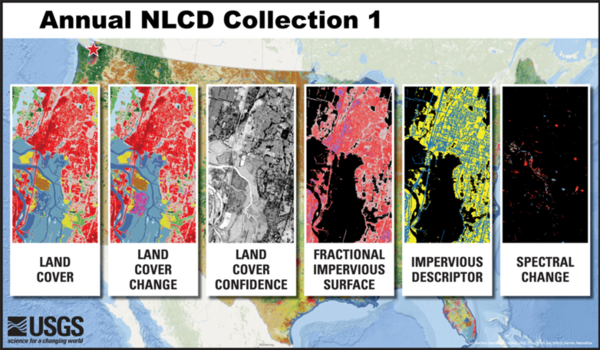
The six different Annual NLCD science products, with examples all shown of the Marysville, Washington, area.
“We had to rely a lot more on the spectral imagery and also on deep learning to do a better job of inferring what’s happening in the Landsat imagery,” Dewitz said. “Deep learning really did a great job of linking all of that data together.”
EROS Center Director Pete Doucette has long been an advocate for the use of data science to help solve scientific challenges. “Annual NLCD is blazing the trail as among the first generation of operational products at EROS that incorporate deep learning methods to improve performance,” Doucette said. “And I believe that we’re just getting started with where we can take machine learning methods at EROS.”
Rylie Fleckenstein, the Research and Development (R&D) technical lead for Annual NLCD and a contractor at EROS, looked at previous methods for producing NLCD and LCMAP to help determine the new Annual NLCD process—“moving away from the hand editing, so to speak, and incorporating algorithms or different approaches to automate the process.”
That production process included a change detection component, like LCMAP had, to determine where and when change had occurred on the landscape, and also a classification component to determine the type of land cover in an area. Some refinement was necessary in areas with trickier or inaccurate classifications.
The resulting new release contains a suite of six products associated with land cover and change:
Land Cover: The predominant land cover class
Land Cover Change: The change between one year and the next
Land Cover Confidence: The probability value for the land cover class
Fractional Impervious Surface: The amount of area covered by artificial surfaces like pavement or concrete
Impervious Descriptor: The differentiation between roads and other artificial surfaces
Spectral Change Day of Year: The timing of a significant change in Landsat data
Team Met Challenges During ‘Intense Two Years’
Brown estimated about 30 people have been involved in producing Annual NLCD. That includes scientists and engineers involved in the research and production stages, and also those collecting reference data to check for errors and validate the results.
Dewitz praised the team for all they accomplished in the two-year timeframe. “The R&D team was challenged and pushed, and they performed wonderfully,” he said.
The engineering side had to do much of their work while R&D was still going on. “Thankfully we have an excellent engineering team,” Dewitz said. “They worked in pieces and did kind of a hybrid engineering process.”
Sohl, the EROS science chief, thinks the infrastructure developed to produce Annual NLCD should be helpful for other science projects, too.
“This has been an intense two years,” Sohl said. “I'm just so proud of the team. They have worked so hard, and they performed a minor miracle in terms of completely revamping the methodology and moving all of the technology into the cloud. Now that we have this infrastructure set up, it really facilitates the next level of improvements for Annual NLCD.”
Green field borders white and red rock cliffs
Chicago River Skyline from Water
Sand dune along the Colorado River in Grand Canyon
Improvements Helpful for Heat and Flooding Studies
Annual NLCD is national in scope, but on a local level, it fills the need that cities or other entities have for detailed and accurate land cover information that spans decades.
George Xian, a research physical scientist at EROS, is grateful that Annual NLCD has arrived so he can start using it in his urban heat island work. He is in the midst of expanding his study of trends in changing average surface temperatures and hotspot locations from 50 to 300 U.S. cities.
This type of information is important for cities to know because they can develop plans to help residents cope during periods of extreme heat, which can cause illness or death in vulnerable populations.
For the 50-city study, Xian and his colleagues needed the annual land cover data beginning with 1985 that LCMAP provided, but also the more detailed information about paved surfaces, concrete and rooftops—collectively called impervious surfaces, which typically retain more heat—contained in NLCD. “We had to use a so-called hybrid way to integrate NLCD and LCMAP to gather the data for this four-category urban area and also annual change,” Xian said.
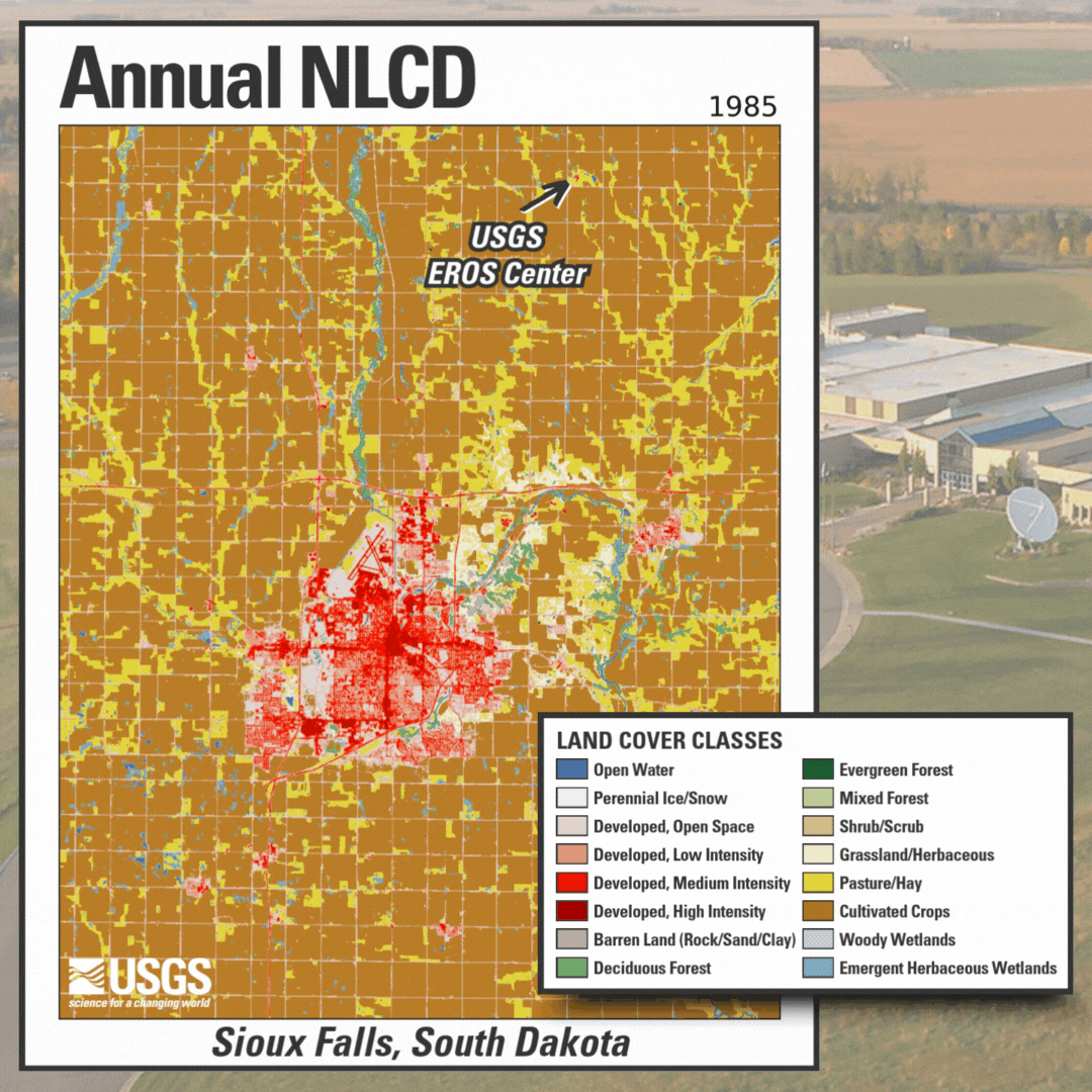
The Annual National Land Cover Database (NLCD) is produced at the USGS EROS Center, which is located in a rural area north of Sioux Falls. Sioux Falls has steadily grown in size and population, as seen here in red in an Annual NLCD animation spanning nearly 40 years. Annual NLCD provides four different developed classes to provide more detailed information about cities.
For the expanded study with more than 300 cities from 1985 to 2023, Xian said, “we can use Annual NLCD to directly define our urban categories into four categories. We can study their variations and their variation impact to the urban heat island. We can directly pull the data into our algorithm and use it. We don't need to regenerate the data.”
Ryan Corcoran is looking forward to using Annual NLCD as well. He serves as the Coordinated Needs Management Strategy (CNMS) team lead at Niyam IT, which is part of the Advancing Resilience in Communities joint venture that provides planning, engineering and mapping support for FEMA’s Zone 1. One aspect that Corcoran and his colleagues work with involves checking whether flood studies of river and coastal areas remain valid after a period of time, or whether conditions have changed and require a new study.
In the past, Corcoran said they have had to use multiple data sources, including NLCD, for baseline watershed information and to assess annual changes.
“We are excited about the upcoming expansion of the NLCD. It will make it easier for us to calculate baseline watershed imperviousness and land use changes using a single dataset,” Corcoran said. “The availability of this extensive data is critical, as we sometimes validate flood studies that date back to the 1970s. Increased data availability allows us to better evaluate flood risk, especially when validating older flood studies.”
“We’re trying to respond to people’s requests for data in all kinds of different ways,” said Brown, the Annual NLCD project manager.
The data will be updated more frequently, too. “In the past, it’s usually taken over a year, if not more, to do an NLCD update,” said science branch chief Sohl. “We’re setting the stage where, by the middle of every year, we’re going to have an update for the previous year.”
Annual NLCD is providing more useful information more quickly for the people relying on it—which, as it turns out, might be most of us, with NLCD’s history as a key source of data woven into the background of society.
“Annual NLCD represents the next generation of highly accurate mapping information that keeps pace with evolving user needs,” said EROS Director Doucette. “Annual NLCD products will become increasingly relevant toward assessing land use and land condition. They provide key change indicators for understanding environmental interactions and consequences. These are the kinds of things that decision makers ultimately want to know.”
Land cover is foundational information for land managers, scientists, and the general public. Many types of scientific studies have applied annual land cover information including projecting future land use, documenting forest fragmentation or conservation practices, modeling wildfire hazards, tracking water quality and quantity, and understanding change in wildlife habitat and ecosystem...
Land cover is foundational information for land managers, scientists, and the general public. Many types of scientific studies have applied annual land cover information including projecting future land use, documenting forest fragmentation or conservation practices, modeling wildfire hazards, tracking water quality and quantity, and understanding change in wildlife habitat and ecosystem...
The U.S. Geological Survey (USGS)’s Land Cover program has leveraged methodologies from legacy land cover projects - National Land Cover Database (NLCD) and Land Change Monitoring, Assessment, and Projection (LCMAP) - together with modern innovations in geospatial deep learning technologies to create the next generation of land cover and land change information. The product suite is...
A validation assessment of Annual National Land Cover Dataset (NLCD) CONUS Collection 1.0 annual land cover products (1985–2023) for the Conterminous United States (CONUS) was conducted with an independently collected reference dataset. Reference data land cover attributes were assigned by trained interpreters for each year of the time series (1984–2023) to a reference sample of 8,360...
This Annual NLCD Reference Data Product includes the collection of an independent dataset of 8,360 30-meter by 30-meter samples across the Conterminous United States (CONUS). The Annual NLCD Collection 1 sample design was developed as a two-phase collection by a team of image interpreters as follows: an initial base sample containing 5,000 sample plots chosen purely by simple random...
Data collected to facilitate research and development activities pertaining to Annual NLCD algorithm development used as a benchmark for algorithm improvement iterations. The primary goal of these preliminary data was to offer preliminary insight into algorithm performance and guidance for algorithm improvement through error analysis.
View a webinar about the new Annual NLCD release, listen to podcast episodes and check out these animations created from nearly 40 years of imagery in Annual NLCD.
This video is a recording of a previous webinar entitled: “The New Annual (1985-2023) National Land Cover Database: Improving on a 30-year Legacy.” This webinar was recorded on October 24, 2024 at the USGS EROS. The United States Geological Survey (USGS) Earth Resources Observation and Science (EROS) Center maintains one of the largest civilian collection of images of the Earth’s land surface. At...
Eyes on Earth Episode 131 – Using AI in Geospatial Work
Eyes on Earth tackles artificial intelligence (AI) in a 2-part episode. AI is quickly becoming a necessary part of geospatial work at EROS, helping us efficiently do science to better manage our world. In Part 1, EROS Director Pete Doucette discusses AI and its current and upcoming impact on our work at EROS.
Eyes on Earth tackles artificial intelligence (AI) in a 2-part episode. AI is quickly becoming a necessary part of geospatial work at EROS, helping us efficiently do science to better manage our world. In Part 1, EROS Director Pete Doucette discusses AI and its current and upcoming impact on our work at EROS.
Every pixel has a story. At least that’s how land remote sensing scientist Jo Horton sees it. The new Annual National Land Cover Database (NLCD) was just released in October 2024. NLCD is widely used for land cover and change research in the U.S.
Every pixel has a story. At least that’s how land remote sensing scientist Jo Horton sees it. The new Annual National Land Cover Database (NLCD) was just released in October 2024. NLCD is widely used for land cover and change research in the U.S.
In this episode of Eyes on Earth, we talk about the latest release of the National Land Cover Database (NLCD). More than just a map, NLCD is a stack of maps—a database. It has long been the foundational land cover source for scientists, resource managers, and decision-makers across the United States, and now the next generation of USGS land cover mapping is here.
In this episode of Eyes on Earth, we talk about the latest release of the National Land Cover Database (NLCD). More than just a map, NLCD is a stack of maps—a database. It has long been the foundational land cover source for scientists, resource managers, and decision-makers across the United States, and now the next generation of USGS land cover mapping is here.
Annual NLCD (1985-2023) Animation for the Great Salt Lake and Salt Lake Valley, Utah
Annual NLCD is a new generation of land cover mapping that offers annual land cover and land change science products nationwide with nearly four decades of data. Learn more here: https://usgs.gov/annualnlcd
Annual NLCD is a new generation of land cover mapping that offers annual land cover and land change science products nationwide with nearly four decades of data. Learn more here: https://usgs.gov/annualnlcd
Land cover change in the northern Dallas-Fort Worth area from 1985-2023 as shown by Annual NLCD Collection 1.0
An animation of images from the Annual National Land Cover Database (NLCD) for every year from 1985 through 2023 showing land cover changes and the progression of growth of urban areas (in red) in the northern Dallas-Fort Worth, Texas, metropolitan area.
An animation of images from the Annual National Land Cover Database (NLCD) for every year from 1985 through 2023 showing land cover changes and the progression of growth of urban areas (in red) in the northern Dallas-Fort Worth, Texas, metropolitan area.
Land cover information is essential for understanding Earth’s surface dynamics and how vegetation, water, soil, climate, and terrain interact. The National Land Cover Database (NLCD) has been the authoritative source for consistent U.S. land cover mapping. To extend NLCD’s temporal resolution and reduce production latency, we developed the Land Cover Artificial Mapping System (LCAMS)—a...
Authors
Rylie Fleckenstein, Danika Fay Wellington, Suming Jin, Heather J. Tollerud, Jesslyn F. Brown, Jon Dewitz, Neal J. Pastick, Christopher P. Barber, Austin O'Brien, Mark Spanier
The National Land Cover Database (NLCD), developed through the Multi-Resolution Land Characteristics Consortium, was initiated 30 years ago and has continually provided critical, Landsat-based landcover and land-change information for the United States. Originally launched to address the lack of national-scale, moderate-resolution land-cover data, NLCD has evolved from the pioneering...
Authors
Terry L. Sohl, Suming Jin, Jon Dewitz, James Wickham, Jesslyn F. Brown, Stephen Stehman, Nathaniel Herold, Karen Schleeweis, Heather J. Tollerud, Carol Deering
RESTON, Va. — The U.S. Geological Survey today released a newly updated and improved National Land Cover Database, known as Annual NLCD, which offers insights into the changing characteristics of landscapes across the conterminous United States from 1985 to 2023.
A View of Vigorous Growth: Williston, North Dakota
When we think of growth across the United States, we tend to think of medium or large cities with suburbs that expand into the surrounding area, such...
The southeastern United States is an important wood-producing region of the world, sometimes referred to as the wood basket. The state of Georgia is a...
New Reference and Validation Data Available for Annual NLCD
The U.S. Geological Survey (USGS) has released the reference and validation data for Annual National Land Cover Database (NLCD) Conterminous U.S. (CU)...
Annual NLCD Assessment: Phosphate Mining and Land Cover Change
Populations around the world are increasing (US Census Bureau, 2023). As agriculture tries to keep up with feeding this growing population, the use of...
Land cover is foundational information for land managers, scientists, and the general public. Many types of scientific studies have applied annual land cover information including projecting future land use, documenting forest fragmentation or conservation practices, modeling wildfire hazards, tracking water quality and quantity, and understanding change in wildlife habitat and ecosystem...
Land cover is foundational information for land managers, scientists, and the general public. Many types of scientific studies have applied annual land cover information including projecting future land use, documenting forest fragmentation or conservation practices, modeling wildfire hazards, tracking water quality and quantity, and understanding change in wildlife habitat and ecosystem...
The U.S. Geological Survey (USGS)’s Land Cover program has leveraged methodologies from legacy land cover projects - National Land Cover Database (NLCD) and Land Change Monitoring, Assessment, and Projection (LCMAP) - together with modern innovations in geospatial deep learning technologies to create the next generation of land cover and land change information. The product suite is...
A validation assessment of Annual National Land Cover Dataset (NLCD) CONUS Collection 1.0 annual land cover products (1985–2023) for the Conterminous United States (CONUS) was conducted with an independently collected reference dataset. Reference data land cover attributes were assigned by trained interpreters for each year of the time series (1984–2023) to a reference sample of 8,360...
This Annual NLCD Reference Data Product includes the collection of an independent dataset of 8,360 30-meter by 30-meter samples across the Conterminous United States (CONUS). The Annual NLCD Collection 1 sample design was developed as a two-phase collection by a team of image interpreters as follows: an initial base sample containing 5,000 sample plots chosen purely by simple random...
Data collected to facilitate research and development activities pertaining to Annual NLCD algorithm development used as a benchmark for algorithm improvement iterations. The primary goal of these preliminary data was to offer preliminary insight into algorithm performance and guidance for algorithm improvement through error analysis.
View a webinar about the new Annual NLCD release, listen to podcast episodes and check out these animations created from nearly 40 years of imagery in Annual NLCD.
This video is a recording of a previous webinar entitled: “The New Annual (1985-2023) National Land Cover Database: Improving on a 30-year Legacy.” This webinar was recorded on October 24, 2024 at the USGS EROS. The United States Geological Survey (USGS) Earth Resources Observation and Science (EROS) Center maintains one of the largest civilian collection of images of the Earth’s land surface. At...
Eyes on Earth Episode 131 – Using AI in Geospatial Work
Eyes on Earth tackles artificial intelligence (AI) in a 2-part episode. AI is quickly becoming a necessary part of geospatial work at EROS, helping us efficiently do science to better manage our world. In Part 1, EROS Director Pete Doucette discusses AI and its current and upcoming impact on our work at EROS.
Eyes on Earth tackles artificial intelligence (AI) in a 2-part episode. AI is quickly becoming a necessary part of geospatial work at EROS, helping us efficiently do science to better manage our world. In Part 1, EROS Director Pete Doucette discusses AI and its current and upcoming impact on our work at EROS.
Every pixel has a story. At least that’s how land remote sensing scientist Jo Horton sees it. The new Annual National Land Cover Database (NLCD) was just released in October 2024. NLCD is widely used for land cover and change research in the U.S.
Every pixel has a story. At least that’s how land remote sensing scientist Jo Horton sees it. The new Annual National Land Cover Database (NLCD) was just released in October 2024. NLCD is widely used for land cover and change research in the U.S.
In this episode of Eyes on Earth, we talk about the latest release of the National Land Cover Database (NLCD). More than just a map, NLCD is a stack of maps—a database. It has long been the foundational land cover source for scientists, resource managers, and decision-makers across the United States, and now the next generation of USGS land cover mapping is here.
In this episode of Eyes on Earth, we talk about the latest release of the National Land Cover Database (NLCD). More than just a map, NLCD is a stack of maps—a database. It has long been the foundational land cover source for scientists, resource managers, and decision-makers across the United States, and now the next generation of USGS land cover mapping is here.
Annual NLCD (1985-2023) Animation for the Great Salt Lake and Salt Lake Valley, Utah
Annual NLCD is a new generation of land cover mapping that offers annual land cover and land change science products nationwide with nearly four decades of data. Learn more here: https://usgs.gov/annualnlcd
Annual NLCD is a new generation of land cover mapping that offers annual land cover and land change science products nationwide with nearly four decades of data. Learn more here: https://usgs.gov/annualnlcd
Land cover change in the northern Dallas-Fort Worth area from 1985-2023 as shown by Annual NLCD Collection 1.0
An animation of images from the Annual National Land Cover Database (NLCD) for every year from 1985 through 2023 showing land cover changes and the progression of growth of urban areas (in red) in the northern Dallas-Fort Worth, Texas, metropolitan area.
An animation of images from the Annual National Land Cover Database (NLCD) for every year from 1985 through 2023 showing land cover changes and the progression of growth of urban areas (in red) in the northern Dallas-Fort Worth, Texas, metropolitan area.
Land cover information is essential for understanding Earth’s surface dynamics and how vegetation, water, soil, climate, and terrain interact. The National Land Cover Database (NLCD) has been the authoritative source for consistent U.S. land cover mapping. To extend NLCD’s temporal resolution and reduce production latency, we developed the Land Cover Artificial Mapping System (LCAMS)—a...
Authors
Rylie Fleckenstein, Danika Fay Wellington, Suming Jin, Heather J. Tollerud, Jesslyn F. Brown, Jon Dewitz, Neal J. Pastick, Christopher P. Barber, Austin O'Brien, Mark Spanier
The National Land Cover Database (NLCD), developed through the Multi-Resolution Land Characteristics Consortium, was initiated 30 years ago and has continually provided critical, Landsat-based landcover and land-change information for the United States. Originally launched to address the lack of national-scale, moderate-resolution land-cover data, NLCD has evolved from the pioneering...
Authors
Terry L. Sohl, Suming Jin, Jon Dewitz, James Wickham, Jesslyn F. Brown, Stephen Stehman, Nathaniel Herold, Karen Schleeweis, Heather J. Tollerud, Carol Deering
RESTON, Va. — The U.S. Geological Survey today released a newly updated and improved National Land Cover Database, known as Annual NLCD, which offers insights into the changing characteristics of landscapes across the conterminous United States from 1985 to 2023.
A View of Vigorous Growth: Williston, North Dakota
When we think of growth across the United States, we tend to think of medium or large cities with suburbs that expand into the surrounding area, such...
The southeastern United States is an important wood-producing region of the world, sometimes referred to as the wood basket. The state of Georgia is a...
New Reference and Validation Data Available for Annual NLCD
The U.S. Geological Survey (USGS) has released the reference and validation data for Annual National Land Cover Database (NLCD) Conterminous U.S. (CU)...
Annual NLCD Assessment: Phosphate Mining and Land Cover Change
Populations around the world are increasing (US Census Bureau, 2023). As agriculture tries to keep up with feeding this growing population, the use of...


 National Land Cover Database: Improving on a 30-Year Legacy")


