
Florence Bascom Geoscience Center
The primary mission of the Florence Bascom Geoscience Center (FBGC) is to provide detailed scientific data and assessments to support natural resource management, public safety, and national security. The FBGC specializes in:
Geologic mapping and hazards
Paleontology, stratigraphy, and environmental geology
Special geologic studies at the intersection of national security and mineral resources
USGS Scientists Help Address Conflict Mining

The USGS has collaborated with several international organizations working to track and monitor illegal mining and armed groups funded by natural resources around the world.
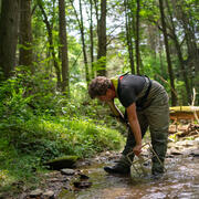
Mid-Atlantic Stream & Sediment Science

FBGC's ecologist Greg Noe's work is highlighted in this great article discussing legacy erosion and sedimentation in Mid-Atlantic watersheds.
Climate Change Impacts on Mangrove Forests

FBGC scientists Miriam Jones and Lynn Wingard were recently interviewed by NPR regarding climate change and mangrove forests.
Publications
Creating 3D point clouds, digital elevation models, and orthomosaics from historical aerial imagery through structure from motion aided photogrammetry Creating 3D point clouds, digital elevation models, and orthomosaics from historical aerial imagery through structure from motion aided photogrammetry
Stratigraphic notes—Volume 3, 2026 Stratigraphic notes—Volume 3, 2026
Science
Evaluating the Effects of Stream-Restoration Practices in an Impaired Agricultural System

The “sediment shadow” in Chesapeake Bay’s tidal freshwater rivers has important implications for restoration
