
Central Plains Water Science Center
Welcome to the U.S. Geological Survey Central Plains Water Science Center. We deliver high-quality, impartial data and scientific research on water resources across Kansas and Nebraska. Our work supports informed decision-making by Federal, State, Tribal, and local partners, helping to ensure public safety, environmental sustainability, and effective water management. Explore our site to access streamflow, groundwater, and water-quality data, as well as our latest research and publications.
Current water conditions in Kansas and Nebraska
Current water conditions in Kansas and Nebraska
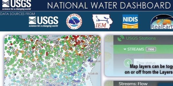
Explore real-time streamflow, groundwater, and water-quality conditions in Kansas and Nebraska and access data through an interactive map.
National Real-Time Water Quality Data
National Real-Time Water Quality Data
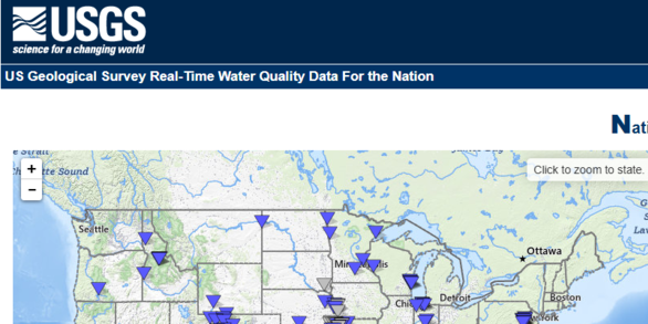
Visualize and access real-time water quality data, including sites in Kansas and Nebraska.
News
Central Plains Water Science Center Quarterly Newsletter - March 2026
Central Plains Water Science Center Quarterly Newsletter - March 2026
The Central Plains Water Science Center Presents: Science Seminar Series - March 2026
The Central Plains Water Science Center Presents: Science Seminar Series - March 2026
The Central Plains Water Science Center Presents: Science Seminar Series - January 2026
The Central Plains Water Science Center Presents: Science Seminar Series - January 2026
Publications
An inset groundwater-flow model to evaluate the effects of layering configuration on model calibration and assess managed aquifer recharge near Shellmound, Mississippi An inset groundwater-flow model to evaluate the effects of layering configuration on model calibration and assess managed aquifer recharge near Shellmound, Mississippi
The U.S. Geological Survey has developed a high-resolution inset groundwater-flow model in the Mississippi Delta as part of an interdisciplinary collaboration coordinated by the Mississippi Alluvial Plain project to provide a tool that stakeholders can use to support water-resource management decisions. Groundwater withdrawals from the Mississippi River Valley alluvial (MRVA) aquifer...
Flood-inundation maps for 14.8 miles of Little and Big Papillion Creeks in Omaha, Nebraska, 2023 Flood-inundation maps for 14.8 miles of Little and Big Papillion Creeks in Omaha, Nebraska, 2023
Digital flood-inundation map libraries for two reaches that constitute 14.8 miles of Little and Big Papillion Creeks in Omaha, Nebraska, were created by the U.S. Geological Survey (USGS) in cooperation with the Papio-Missouri River Natural Resource District. The flood-inundation maps, which can be accessed through the USGS Flood Inundation Mapping Program website at https://www.usgs.gov...
6PPD-quinone in water from the San Francisco-San Joaquin Delta, California, 2018-2024 6PPD-quinone in water from the San Francisco-San Joaquin Delta, California, 2018-2024
The Sacramento-San Joaquin Delta (Delta) is an expansive river delta supplying a large portion of California’s fresh water for agriculture and residential use, and it is also an area of critical habitat for numerous state and federally listed species of concern. In many locations, urban stormwater flows directly into the Delta. 6PPD-quinone (6PPD-Q), an ozonation byproduct of a tire...
Science
Tracking Toxins at the Coastline: A National Look at Harmful Algal Toxins in U.S. Coastal Waters
This study is a major step forward in understanding how harmful algal blooms, which are often associated with lakes and rivers, can also affect coastal environments. It provides important baseline information for scientists, public health officials, and environmental managers.

Effect of Water-Injection Dredging (WID) Operations on Water Quality Downstream from Tuttle Creek Reservoir
USGS continuous water-quality monitoring and discrete sampling is an integral component for understanding pre-, during, and post-WID water-quality conditions and the impacts on the surrounding ecosystems.

Equus Beds Aquifer Storage and Recovery (ASR) Project
The water supply for the city of Wichita, south-central Kansas, currently comes from the Equus Beds aquifer and Cheney Reservoir. Because these sources are not expected to meet projected city water needs into the 21st century (Warren and others, 1995), artificial recharge of the Equus Beds aquifer was investigated as one alternative to meet future water-supply demands. An additional potential...


