
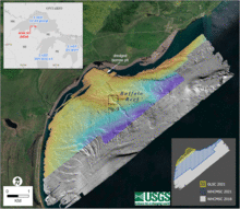
Bathymetric map of Grand Traverse Bay, Lake Superior
By Woods Hole Coastal and Marine Science Center
2021 (approx.)

Detailed Description
Bathymetric map of Grand Traverse Bay, Lake Superior. The 2018 data are shown in gray hillshade, with the combined 2021 data superimposed in color. Index map at lower right shows the extent of each survey.
Sources/Usage
Public Domain.