
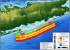
Coastal Vulnerability Index offshore Fire Island, NY

Detailed Description
The Coastal Vulnerability Index (CVI) provides insight into the relative potential of coastal change due to future sea-level rise. The maps and data presented here can be viewed in at least two ways: 1) as an example of where physical changes are most likely to occur as sea-level rises; and 2) as a planning tool for Fire Island National Seashore.
Sources/Usage
Public Domain.
Related

Coastal Vulnerability in National Park Units
These Open-File Reports are part of a joint effort by the U.S. Geological Survey and the National Park Service to map the coastal vulnerability of coastal park units.
Relative Coastal Vulnerability Assessment of National Park Units to Sea-Level Rise
The National Park Service (NPS) is responsible for managing nearly 12,000 km (7,500 miles) of shoreline along oceans and lakes. In 2001 the U.S. Geological Survey (USGS), in partnership with the NPS Geologic Resources Division, began conducting hazard assessments of future sea-level change by creating maps to assist NPS in managing its valuable resources. This website contains results of the...
Related
Coastal Vulnerability in National Park Units
These Open-File Reports are part of a joint effort by the U.S. Geological Survey and the National Park Service to map the coastal vulnerability of coastal park units.
Relative Coastal Vulnerability Assessment of National Park Units to Sea-Level Rise
The National Park Service (NPS) is responsible for managing nearly 12,000 km (7,500 miles) of shoreline along oceans and lakes. In 2001 the U.S. Geological Survey (USGS), in partnership with the NPS Geologic Resources Division, began conducting hazard assessments of future sea-level change by creating maps to assist NPS in managing its valuable resources. This website contains results of the...