
Collecting Bathymetric Data in San Francisco Bay

Detailed Description
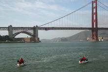
USGS scientists Patrick Barnard (left) and Jeff Hansen navigate personal watercraft equipped with GPS and echo sounders through the waters of San Francisco Bay. They are collecting bathymetric, or depth, information in order to create maps of the bottom of the Bay. The maps will be used to determine how the morphology or shape of the Bay floor changes through time.
Sources/Usage
Public Domain.
Related

Dynamic coastlines along the western U.S.
The west coast of the United States is extremely complex and changeable because of tectonic activity, mountain building, and land subsidence. These active environments pose a major challenge for accurately assessing climate change impacts, since models were historically developed for more passive sandy coasts.
Related
Dynamic coastlines along the western U.S.
The west coast of the United States is extremely complex and changeable because of tectonic activity, mountain building, and land subsidence. These active environments pose a major challenge for accurately assessing climate change impacts, since models were historically developed for more passive sandy coasts.