
Core Data From Offshore Puerto Rico and the U.S. Virgin Islands

Detailed Description
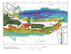
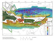
In 2008, as a collaborative effort between Woods Hole Oceanographic Institution and the U.S. Geological Survey, 20 giant gravity cores were collected from areas surrounding Puerto Rico and the U.S. Virgin Islands. The regions sampled have had many large earthquake and landslide events, some of which are believed to have triggered tsunamis. The objective of this coring cruise, carried out aboard the National Oceanic and Atmospheric Administration research vessel Seward Johnson, was to determine the age of several substantial slope failures and seismite layers near Puerto Rico in an effort to map their temporal distribution. Data gathered from the cores collected in 2008 and 11 archive cores from the Lamont-Doherty Earth Observatory are included in this report. These data include lithologic logs, core summary sheets, x-ray fluorescence, wet-bulk density, magnetic susceptibility, grain-size analyses, radiographs, and radiocarbon age dates.
Visit the Open File Report for more information.
Hoy, S.K., Chaytor, J.D., and ten Brink, U.S., 2014, Core data from offshore Puerto Rico and the U.S. Virgin Islands: U.S. Geological Survey Open-File Report 2014–1227, https://dx.doi.org/10.3133/ofr20141227.
Sources/Usage
Public Domain.
Related

Puerto Rico Natural Hazards: Tsunamis | Peligros naturales de Puerto Rico: Maremotos
Related