
Test track from 1970’s commercial dredging equipment trials through a nodule field on the Blake Plateau, imaged in 2022 from an autonomous underwater vehicle (BOEM/USGS).
Jason Chaytor, PhD
I work on a variety of marine geological and geohazard topics including sedimentary processes and geochronology of submarine slope failures, deep-sea sedimentary systems, submarine geomorphology, and neotectonics in marine and near-shore environments.
Dr. Jason Chaytor is a research geologist with the U.S. Geological Survey at the USGS Woods Hole Coastal and Marine Science Center. Jason conducts research on issues related to marine geohazards including submarine landslides, tsunamis, earthquakes, and plate tectonics and shallow- and deep-water sedimentary processes on Atlantic, Gulf of Mexico and Pacific margins of the U.S. and in the northeast Caribbean. He is the current principle scientist for the USGS Woods Hole Coastal and Marine Science Center Sediments Laboratory.
Research Interests
Marine Geohazards
Marine geohazards are sudden and extreme geologic events that affect coastal areas and seabed infrastructure on regional and transoceanic scales. The hazards include submarine earthquakes, submarine slope failures, and tsunami generation. The sediment record of past offshore and coastal hazardous events is generally more complete in the marine environment than on land and can be investigated with geological and geophysical tools. My research involves the identification and characterization of areas of the seafloor and subseafloor within and adjacent to the U.S. EEZ that record a history of fault movement or slope failure (or have the potential to be effected by these processes in the future). Included in this work is the development of conceptual models of seafloor movement and local/regional sedimentation patterns and supporting geochronological frameworks, formulation, planning and performance of field sampling and geophysical imaging activities and laboratory analyses, investigation of local and regional sedimentation processes, and communication of event characteristics to modelers and other stake holders to aid in developing hazard assessments.
Marine Sedimentation Processes and Framework Geology
I investigate dynamic shallow-water (< 200 m) and deep-water sedimentary environments to characterize physical properties affecting acoustic propagation (ONR Mud Patch Project), to evaluate the hazard of recurring seafloor motion to critical offshore infrastructure, and in the development of regional geologic analysis of surfical geologic processes across multiple potential areas of interest in to the U.S. Extended Continental Shelf Project.
Science and Products
Offshore Analysis of Seafloor Instability and Sediments (OASIS)
The Offshore Analysis of Seafloor Instability and Sediments (OASIS) project is an interagency partnership coordinated by the Bureau of Ocean Energy Management to better understand underwater mudslides and their impacts in the Mississippi River Delta Front. The USGS plays a central role in the project, contributing long-term expertise in coastal and marine geology, seafloor mapping, and geohazard...

Environmental Impacts following the 1970 Testing of Seabed Mining Equipment on the Blake Plateau- Quantification of Benthic Communities Across Disturbance Gradients
USGS researchers will characterize the ecology of benthic communities associated with deep-sea environments, including hardground features and adjacent soft sediments, and will build upon previous work conducted in areas off the U.S. east coast under consideration for oil and gas leases.

Puerto Rico Natural Hazards: Earthquakes | Peligros naturales de Puerto Rico: Terremotos
USGS provides real-time earthquake data, information on historic earthquakes, resources for the most significant earthquakes, and seismicity and ground motions to support future updates to the seismic hazard models for Puerto Rico and the U.S. Virgin Islands. Our seismic research can help establish better building regulations that mitigate earthquake risks and improve public safety. The USGS...

Puerto Rico Natural Hazards: Tsunamis | Peligros naturales de Puerto Rico: Maremotos
Tsunamis are long waves formed from a sudden displacement of the sea floor due to a fault rupture, landslide, or volcanic activity. Given that Puerto Rico lies above a subduction zone in the Caribbean Sea, it is especially susceptible to large earthquakes and tsunamis. The greatest tsunami ever recorded in Puerto Rico occurred from an earthquake off the Mona Passage in 1918. The USGS Earthquake...

USGS Role in DEEP SEARCH: Deep Sea Exploration to Advance Research on Coral, Canyon, and Cold-seep Habitats
USGS scientists are collaborating with multiple agencies to provide the esssential foundation for understanding these deep-sea environments.
By
Ecosystems Mission Area, Land Management Research Program, Pacific Coastal and Marine Science Center, St. Petersburg Coastal and Marine Science Center, Wetland and Aquatic Research Center , Woods Hole Coastal and Marine Science Center, Deep Sea Exploration, Mapping and Characterization, Gulf of America

DISCOVRE: Diversity, Systematics and Connectivity of Vulnerable Reef Ecosystems
DISCOVRE ( DIversity, Systematics and COnnectivity of Vulnerable Reef Ecosystems) is an integrated, multidisciplinary, international effort investigating the unique and fragile deep-sea coral environments from the microscopic level to the ecosystem level.

Blake DVI test track
Test track from 1970’s commercial dredging equipment trials through a nodule field on the Blake Plateau, imaged in 2022 from an autonomous underwater vehicle (BOEM/USGS).

Mega Multicorer
First recovered core using the new mega multicorer during a survey of the Mississippi River Delta Front on the R/V Pelican, September 2022. A total of 1.13 m of sediment was recovered in this core, with a fully preserved sediment-water interface.
First recovered core using the new mega multicorer during a survey of the Mississippi River Delta Front on the R/V Pelican, September 2022. A total of 1.13 m of sediment was recovered in this core, with a fully preserved sediment-water interface.

Mega Multicorer Recovery
USGS Marine Operations Specialist, Chuck Worley, assisting with the recovery of the first successful deployment of the new mega multicorer during a survey of the Mississippi River Delta Front on the R/V Pelican, September 2022.
USGS Marine Operations Specialist, Chuck Worley, assisting with the recovery of the first successful deployment of the new mega multicorer during a survey of the Mississippi River Delta Front on the R/V Pelican, September 2022.

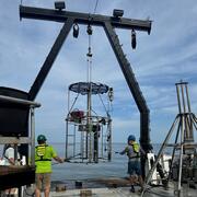
Mega Multicorer Rigged for Deployment
New customized USGS Coastal and Marine Hazards and Resources Program “mega multicorer” fabricated by OSIL and instrumented by WHCMSC marine technicians ready for deployment on the R/V Pelican on the Mississippi River Delta Front, September 2022.
New customized USGS Coastal and Marine Hazards and Resources Program “mega multicorer” fabricated by OSIL and instrumented by WHCMSC marine technicians ready for deployment on the R/V Pelican on the Mississippi River Delta Front, September 2022.

Annotated Mega Multicorer Rigged for Deployment
Annotated view of the Instruments attached to the new customized USGS Coastal and Marine Hazards and Resources Program mega multicorer.
Annotated view of the Instruments attached to the new customized USGS Coastal and Marine Hazards and Resources Program mega multicorer.

Jumbo Piston Corer
Deep water camera and light installed in the head weight of the upgraded USGS jumbo piston corer. In the background, USGS Marine Engineering Technician Daniel Powers is preparing the core liner for sediment collection.
By
Coastal and Marine Hazards and Resources Program, Pacific Coastal and Marine Science Center, Woods Hole Coastal and Marine Science Center, 3-D CT Core Imaging Laboratory, Core Preparation and Analysis Laboratory and Sample Repositories, Multi-Sensor Core Logger Laboratory, Deep Sea Exploration, Mapping and Characterization

Jumbo Piston Corer
Pete Dal Ferro, USGS Marine Engineering Technician and lead fabricator on the JPC upgrade, monitors the testing of the coring system on R/V Hugh R. Sharp in March 2022.
Pete Dal Ferro, USGS Marine Engineering Technician and lead fabricator on the JPC upgrade, monitors the testing of the coring system on R/V Hugh R. Sharp in March 2022.

Jumbo Piston Corer
Upgraded USGS jumbo piston corer being readied for deployment off the research vessel Hugh R. Sharp in April 2022.
Upgraded USGS jumbo piston corer being readied for deployment off the research vessel Hugh R. Sharp in April 2022.
Science and Products
Offshore Analysis of Seafloor Instability and Sediments (OASIS)
The Offshore Analysis of Seafloor Instability and Sediments (OASIS) project is an interagency partnership coordinated by the Bureau of Ocean Energy Management to better understand underwater mudslides and their impacts in the Mississippi River Delta Front. The USGS plays a central role in the project, contributing long-term expertise in coastal and marine geology, seafloor mapping, and geohazard...
Environmental Impacts following the 1970 Testing of Seabed Mining Equipment on the Blake Plateau- Quantification of Benthic Communities Across Disturbance Gradients
USGS researchers will characterize the ecology of benthic communities associated with deep-sea environments, including hardground features and adjacent soft sediments, and will build upon previous work conducted in areas off the U.S. east coast under consideration for oil and gas leases.
Puerto Rico Natural Hazards: Earthquakes | Peligros naturales de Puerto Rico: Terremotos
USGS provides real-time earthquake data, information on historic earthquakes, resources for the most significant earthquakes, and seismicity and ground motions to support future updates to the seismic hazard models for Puerto Rico and the U.S. Virgin Islands. Our seismic research can help establish better building regulations that mitigate earthquake risks and improve public safety. The USGS...
Puerto Rico Natural Hazards: Tsunamis | Peligros naturales de Puerto Rico: Maremotos
Tsunamis are long waves formed from a sudden displacement of the sea floor due to a fault rupture, landslide, or volcanic activity. Given that Puerto Rico lies above a subduction zone in the Caribbean Sea, it is especially susceptible to large earthquakes and tsunamis. The greatest tsunami ever recorded in Puerto Rico occurred from an earthquake off the Mona Passage in 1918. The USGS Earthquake...
USGS Role in DEEP SEARCH: Deep Sea Exploration to Advance Research on Coral, Canyon, and Cold-seep Habitats
USGS scientists are collaborating with multiple agencies to provide the esssential foundation for understanding these deep-sea environments.
By
Ecosystems Mission Area, Land Management Research Program, Pacific Coastal and Marine Science Center, St. Petersburg Coastal and Marine Science Center, Wetland and Aquatic Research Center , Woods Hole Coastal and Marine Science Center, Deep Sea Exploration, Mapping and Characterization, Gulf of America
DISCOVRE: Diversity, Systematics and Connectivity of Vulnerable Reef Ecosystems
DISCOVRE ( DIversity, Systematics and COnnectivity of Vulnerable Reef Ecosystems) is an integrated, multidisciplinary, international effort investigating the unique and fragile deep-sea coral environments from the microscopic level to the ecosystem level.
Blake DVI test track
Test track from 1970’s commercial dredging equipment trials through a nodule field on the Blake Plateau, imaged in 2022 from an autonomous underwater vehicle (BOEM/USGS).
Test track from 1970’s commercial dredging equipment trials through a nodule field on the Blake Plateau, imaged in 2022 from an autonomous underwater vehicle (BOEM/USGS).
Mega Multicorer
First recovered core using the new mega multicorer during a survey of the Mississippi River Delta Front on the R/V Pelican, September 2022. A total of 1.13 m of sediment was recovered in this core, with a fully preserved sediment-water interface.
First recovered core using the new mega multicorer during a survey of the Mississippi River Delta Front on the R/V Pelican, September 2022. A total of 1.13 m of sediment was recovered in this core, with a fully preserved sediment-water interface.
Mega Multicorer Recovery
USGS Marine Operations Specialist, Chuck Worley, assisting with the recovery of the first successful deployment of the new mega multicorer during a survey of the Mississippi River Delta Front on the R/V Pelican, September 2022.
USGS Marine Operations Specialist, Chuck Worley, assisting with the recovery of the first successful deployment of the new mega multicorer during a survey of the Mississippi River Delta Front on the R/V Pelican, September 2022.
Mega Multicorer Rigged for Deployment
New customized USGS Coastal and Marine Hazards and Resources Program “mega multicorer” fabricated by OSIL and instrumented by WHCMSC marine technicians ready for deployment on the R/V Pelican on the Mississippi River Delta Front, September 2022.
New customized USGS Coastal and Marine Hazards and Resources Program “mega multicorer” fabricated by OSIL and instrumented by WHCMSC marine technicians ready for deployment on the R/V Pelican on the Mississippi River Delta Front, September 2022.
Annotated Mega Multicorer Rigged for Deployment
Annotated view of the Instruments attached to the new customized USGS Coastal and Marine Hazards and Resources Program mega multicorer.
Annotated view of the Instruments attached to the new customized USGS Coastal and Marine Hazards and Resources Program mega multicorer.
Jumbo Piston Corer
Deep water camera and light installed in the head weight of the upgraded USGS jumbo piston corer. In the background, USGS Marine Engineering Technician Daniel Powers is preparing the core liner for sediment collection.
By
Coastal and Marine Hazards and Resources Program, Pacific Coastal and Marine Science Center, Woods Hole Coastal and Marine Science Center, 3-D CT Core Imaging Laboratory, Core Preparation and Analysis Laboratory and Sample Repositories, Multi-Sensor Core Logger Laboratory, Deep Sea Exploration, Mapping and Characterization
Jumbo Piston Corer
Pete Dal Ferro, USGS Marine Engineering Technician and lead fabricator on the JPC upgrade, monitors the testing of the coring system on R/V Hugh R. Sharp in March 2022.
Pete Dal Ferro, USGS Marine Engineering Technician and lead fabricator on the JPC upgrade, monitors the testing of the coring system on R/V Hugh R. Sharp in March 2022.
Jumbo Piston Corer
Upgraded USGS jumbo piston corer being readied for deployment off the research vessel Hugh R. Sharp in April 2022.
Upgraded USGS jumbo piston corer being readied for deployment off the research vessel Hugh R. Sharp in April 2022.