
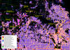
Dallas-Ft. Worth - NLCD 2016 Impervious Descriptor layer
By Earth Resources Observation and Science (EROS) Center
2016 (approx.)

Detailed Description
National Land Cover Database 2016 Impervious Descriptor layer for an area on the western side of Dallas/Ft. Worth, Texas.
Sources/Usage
Public Domain.
Related

LCMAP and NLCD: Complementary Data for Understanding the Geography of the United States
Land Change Monitoring, Assessment, and Projection (LCMAP) Collection 1 science products provide unprecedented monitoring of past changes occurring in land cover and condition across the conterminous U.S. over more than 30 years at an annual timestep.
Related
LCMAP and NLCD: Complementary Data for Understanding the Geography of the United States
Land Change Monitoring, Assessment, and Projection (LCMAP) Collection 1 science products provide unprecedented monitoring of past changes occurring in land cover and condition across the conterminous U.S. over more than 30 years at an annual timestep.