
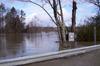
Flooding on the Kennebunk River

Detailed Description
The USGS has been monitoring the Kennebunk River near Kennebunk, Maine since June 2008 and the peak discharge for the period of record occurred in February 2010. This photo was taken as the river crested over that February event and demonstrates the challenge faced by the USGS when it comes to monitoring river conditions during floods. When installing and maintaining our stations we do everything we can to ensure our equipment is flood ready and will continue to operate during floods, when the data is critical.
Sources/Usage
Public Domain.
Related

New England Flood Information
The USGS delivers continuous streamflow, stage (water-level), and tide data to help emergency managers and other decision makers protect life and property caused by floods and other water-related hazards.
Related
New England Flood Information
The USGS delivers continuous streamflow, stage (water-level), and tide data to help emergency managers and other decision makers protect life and property caused by floods and other water-related hazards.