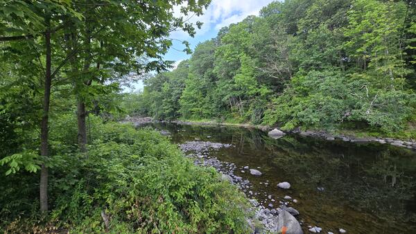
Austin Stream in Binghamton, Maine, During Summer Drought
Austin Stream in Binghamton, Maine, During Summer DroughtA view of Austin Stream in Binghamton, Maine, during a period of moderate drought in the summer of 2025.

Official websites use .gov
A .gov website belongs to an official government organization in the United States.
Secure .gov websites use HTTPS
A lock () or https:// means you’ve safely connected to the .gov website. Share sensitive information only on official, secure websites.
Nicholas Stasulis is a Supervisory Physical Scientist in the New England Water Science Center.
Nick is experienced in collection and publication of hydrologic data; the use of acoustics for measurement of streamflow in open-water and ice conditions; collaborating with partners and cooperators to develop proposals to meet their science needs; and training staff on USGS policies/methodologies for collection of hydrologic data.
Nick began his USGS career as a student with the Maine Water Science Center while attending the University of Maine. After graduation, Nick worked in the Maine Data Program, building an expertise in the collection and publication of streamflow and groundwater data. In addition, Nick took a particular interest in the use of hydroacoustics for measurement of velocity and streamflow. This interest led to opportunities to test new acoustic Doppler current profilers (ADCPs) for the USGS, teach national training courses on the subject, and serve as a member of the USGS Hydroacoustics Work Group (HaWG). Starting in 2016, Nick supervised staff in the Maine Office of the New England Water Science Center, with a focus on streamflow and groundwater monitoring. Beginning in 2024, Nick oversees the Monitoring Operations Section for the New England Water Science Center. Nick also serves on the IJC International St. Croix River Watershed Board, and as co-chair of Maine's Drought Task Force and River Flow Advisory Commission.


A view of Austin Stream in Binghamton, Maine, during a period of moderate drought in the summer of 2025.
A view of Austin Stream in Binghamton, Maine, during a period of moderate drought in the summer of 2025.
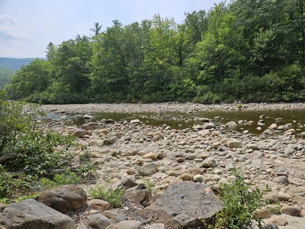
Nezinscot River at Turner Center, Maine, experienced low water levels during a drought event in the summer of 2025.
Nezinscot River at Turner Center, Maine, experienced low water levels during a drought event in the summer of 2025.
Wild River at Gilead, Maine, experienced low water levels during a drought event in the summer of 2025.
Wild River at Gilead, Maine, experienced low water levels during a drought event in the summer of 2025.
Kennebec River in downtown Augusta, Maine during flooding and normal flow. The left photo was taken on December 19, 2023 after a heavy rainstorm. The right photo was taken in September 2024.
Kennebec River in downtown Augusta, Maine during flooding and normal flow. The left photo was taken on December 19, 2023 after a heavy rainstorm. The right photo was taken in September 2024.

An upstream view of the East Branch Penobscot River near the streamgage below Grand Lake Matagamon.
An upstream view of the East Branch Penobscot River near the streamgage below Grand Lake Matagamon.

The streamgage at East Branch Penobscot River below Grand Lake Matagamon in Patton, Maine (01029100) is operated in cooperation with the Penobscot Nation.
The streamgage at East Branch Penobscot River below Grand Lake Matagamon in Patton, Maine (01029100) is operated in cooperation with the Penobscot Nation.

Flooding surrounds USGS streamgage 01029500 on the East Branch of the Penobscot River in Grindstone, Maine. The river flooded after a significant rainstorm added several inches of rain and melted snowpack in late December 2023.
Flooding surrounds USGS streamgage 01029500 on the East Branch of the Penobscot River in Grindstone, Maine. The river flooded after a significant rainstorm added several inches of rain and melted snowpack in late December 2023.

The Kennebec River flooded in downtown Augusta, Maine, after a heavy rainstorm. USGS streamgage 01049320 monitors the streamflow of this area
The Kennebec River flooded in downtown Augusta, Maine, after a heavy rainstorm. USGS streamgage 01049320 monitors the streamflow of this area

Piscataquis River in Maine during flood following a powerful rainstorm. Vicinity of the USGS streamgage 01031500, Piscataquis River near Dover-Foxcroft, Maine on December 19, 2023.
Piscataquis River in Maine during flood following a powerful rainstorm. Vicinity of the USGS streamgage 01031500, Piscataquis River near Dover-Foxcroft, Maine on December 19, 2023.

Aunt Betty Pond Inlet, Acadia National Park, Maine. Photo taken in the mid of summer.
Aunt Betty Pond Inlet, Acadia National Park, Maine. Photo taken in the mid of summer.

Hadlock Brook waterfall in Acadia National Park, Maine as seen from a stone bridge.
Hadlock Brook waterfall in Acadia National Park, Maine as seen from a stone bridge.

Hydrologic technician is taking streamflow measurements in Acadia National Park. A small creek is surrounded by grass and green foliage.
Hydrologic technician is taking streamflow measurements in Acadia National Park. A small creek is surrounded by grass and green foliage.

Hydrologic Technician Sean Thiboldeaux stands in Kebo Brook after making a streamflow measurement and conducting training with staff from Acadia National Park.
Summer 2022 Photo Contest Winner: Nicholas Stasulis, People category
Hydrologic Technician Sean Thiboldeaux stands in Kebo Brook after making a streamflow measurement and conducting training with staff from Acadia National Park.
Summer 2022 Photo Contest Winner: Nicholas Stasulis, People category

USGS Hydrologist sampling in Hunters Brook in Acadia National Park, one of the stations (Lewy Lake at Princeton, Maine - USGS-01019300) used for water quality and quantity sampling.
USGS Hydrologist sampling in Hunters Brook in Acadia National Park, one of the stations (Lewy Lake at Princeton, Maine - USGS-01019300) used for water quality and quantity sampling.

Hunters Brook in Acadia National Park, one of the stations used by the Park for water quality and quantity sampling. This project involves an assessment of the water quantity data collected at this site (and others).
Hunters Brook in Acadia National Park, one of the stations used by the Park for water quality and quantity sampling. This project involves an assessment of the water quantity data collected at this site (and others).

USGS gaging station on the Kenduskeag Stream near Bangor, Maine, station 01037000. This station is downstream of Six Mile Falls, a popular spot during the Kenduskeag Canoe Race.
USGS gaging station on the Kenduskeag Stream near Bangor, Maine, station 01037000. This station is downstream of Six Mile Falls, a popular spot during the Kenduskeag Canoe Race.

The view from the river of the USGS gaging station on the Kennebec River at The Forks, station 01042500 during summer.
The view from the river of the USGS gaging station on the Kennebec River at The Forks, station 01042500 during summer.

Hydrologic Technician Andy Cloutier visited USGS gaging station 01069500 on the Mousam River at West Kennebunk, Maine in mid-April of 2021.
Hydrologic Technician Andy Cloutier visited USGS gaging station 01069500 on the Mousam River at West Kennebunk, Maine in mid-April of 2021.
A view of Austin Stream in Binghamton, Maine, during a period of moderate drought in the summer of 2025.
A view of Austin Stream in Binghamton, Maine, during a period of moderate drought in the summer of 2025.
Nezinscot River at Turner Center, Maine, experienced low water levels during a drought event in the summer of 2025.
Nezinscot River at Turner Center, Maine, experienced low water levels during a drought event in the summer of 2025.
Wild River at Gilead, Maine, experienced low water levels during a drought event in the summer of 2025.
Wild River at Gilead, Maine, experienced low water levels during a drought event in the summer of 2025.
Kennebec River in downtown Augusta, Maine during flooding and normal flow. The left photo was taken on December 19, 2023 after a heavy rainstorm. The right photo was taken in September 2024.
Kennebec River in downtown Augusta, Maine during flooding and normal flow. The left photo was taken on December 19, 2023 after a heavy rainstorm. The right photo was taken in September 2024.
An upstream view of the East Branch Penobscot River near the streamgage below Grand Lake Matagamon.
An upstream view of the East Branch Penobscot River near the streamgage below Grand Lake Matagamon.
The streamgage at East Branch Penobscot River below Grand Lake Matagamon in Patton, Maine (01029100) is operated in cooperation with the Penobscot Nation.
The streamgage at East Branch Penobscot River below Grand Lake Matagamon in Patton, Maine (01029100) is operated in cooperation with the Penobscot Nation.
Flooding surrounds USGS streamgage 01029500 on the East Branch of the Penobscot River in Grindstone, Maine. The river flooded after a significant rainstorm added several inches of rain and melted snowpack in late December 2023.
Flooding surrounds USGS streamgage 01029500 on the East Branch of the Penobscot River in Grindstone, Maine. The river flooded after a significant rainstorm added several inches of rain and melted snowpack in late December 2023.
The Kennebec River flooded in downtown Augusta, Maine, after a heavy rainstorm. USGS streamgage 01049320 monitors the streamflow of this area
The Kennebec River flooded in downtown Augusta, Maine, after a heavy rainstorm. USGS streamgage 01049320 monitors the streamflow of this area
Piscataquis River in Maine during flood following a powerful rainstorm. Vicinity of the USGS streamgage 01031500, Piscataquis River near Dover-Foxcroft, Maine on December 19, 2023.
Piscataquis River in Maine during flood following a powerful rainstorm. Vicinity of the USGS streamgage 01031500, Piscataquis River near Dover-Foxcroft, Maine on December 19, 2023.
Aunt Betty Pond Inlet, Acadia National Park, Maine. Photo taken in the mid of summer.
Aunt Betty Pond Inlet, Acadia National Park, Maine. Photo taken in the mid of summer.
Hadlock Brook waterfall in Acadia National Park, Maine as seen from a stone bridge.
Hadlock Brook waterfall in Acadia National Park, Maine as seen from a stone bridge.
Hydrologic technician is taking streamflow measurements in Acadia National Park. A small creek is surrounded by grass and green foliage.
Hydrologic technician is taking streamflow measurements in Acadia National Park. A small creek is surrounded by grass and green foliage.
Hydrologic Technician Sean Thiboldeaux stands in Kebo Brook after making a streamflow measurement and conducting training with staff from Acadia National Park.
Summer 2022 Photo Contest Winner: Nicholas Stasulis, People category
Hydrologic Technician Sean Thiboldeaux stands in Kebo Brook after making a streamflow measurement and conducting training with staff from Acadia National Park.
Summer 2022 Photo Contest Winner: Nicholas Stasulis, People category
USGS Hydrologist sampling in Hunters Brook in Acadia National Park, one of the stations (Lewy Lake at Princeton, Maine - USGS-01019300) used for water quality and quantity sampling.
USGS Hydrologist sampling in Hunters Brook in Acadia National Park, one of the stations (Lewy Lake at Princeton, Maine - USGS-01019300) used for water quality and quantity sampling.
Hunters Brook in Acadia National Park, one of the stations used by the Park for water quality and quantity sampling. This project involves an assessment of the water quantity data collected at this site (and others).
Hunters Brook in Acadia National Park, one of the stations used by the Park for water quality and quantity sampling. This project involves an assessment of the water quantity data collected at this site (and others).
USGS gaging station on the Kenduskeag Stream near Bangor, Maine, station 01037000. This station is downstream of Six Mile Falls, a popular spot during the Kenduskeag Canoe Race.
USGS gaging station on the Kenduskeag Stream near Bangor, Maine, station 01037000. This station is downstream of Six Mile Falls, a popular spot during the Kenduskeag Canoe Race.
The view from the river of the USGS gaging station on the Kennebec River at The Forks, station 01042500 during summer.
The view from the river of the USGS gaging station on the Kennebec River at The Forks, station 01042500 during summer.
Hydrologic Technician Andy Cloutier visited USGS gaging station 01069500 on the Mousam River at West Kennebunk, Maine in mid-April of 2021.
Hydrologic Technician Andy Cloutier visited USGS gaging station 01069500 on the Mousam River at West Kennebunk, Maine in mid-April of 2021.


