
Fort Funston Structure-from-Motion point clouds

Detailed Description
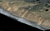
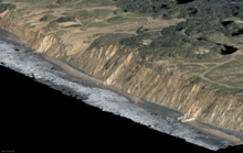
As part of the Remote Sensing of Coastal Change and Florence Supplemental projects we have been developing novel workflows for repeat-mapping of coastal environments at order decimeter resolution over up to hundreds of kilometers in a single day, using Structure-from-Motion photogrammetry or SfM, from crewed aerial platforms. Typically, up to tens of thousands of aerial images collected per flight are used to create accurate digital elevation models (DEMs) and orthomosaics of a large region of coast. Regular repeat image acquisition at this scale and resolution captures coastal change due to storms, which can be both highly spatially variable, and manifest in subtle net topographic and morphological changes.
However, the computational demands of digital terrain reconstruction at such high resolution and large coverage are significant, and products require time-consuming manual editing to remove obviously erroneous data. Specifically, there are two outstanding issues with established SfM workflows. The first is that water does not reconstruct, therefore SfM pipelines spend too much time on a futile task and create erroneous outputs that must be manually removed afterwards. The workaround is to provide a bitmap for each input image, or ‘watermask’, in which water pixels are coded zero and land pixels are coded one, but manual creation of such masks are prohibitively time-consuming. We are using Machine Learning (ML) based image segmentation to automatically generate watermasks for each image used in an SfM pipeline, resulting in reduced reconstruction time and increased accuracy. The second issue is that output DEMs and orthomosaics contain other types of noise due to imperfect photogrammetric modeling that also must be manually removed, which is subjective and time-consuming. We are using ML to automatically flag and remove noise, however defined, from DEM and orthomosaic products. There are accuracy and time tradeoffs between masking inputs, masking outputs, and masking both.
This workflow was used with the post-Hurricane Florence aerial survey. The case study could be helpful to those developing similar systems for automated filtering and quality control of large datasets. Our efforts have involved the development of custom software for semi-automated creation of labeled data, model training and evaluation, and model deployment for automated prediction. This software could be repurposed for almost any automated image segmentation task.
View each image separately:
Sources/Usage
Public Domain.
Related

Science Seminar Series Archives
Related