
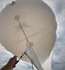
A helikite used to collect imagery of the coastline

Detailed Description
An alternative to uncrewed aerial systems (UAS; commonly known as 'drones'), U.S. Geological Survey (USGS) scientists use helikites equipped with cameras to collect imagery of the coastline. The pictures collected by these helium-powered kite-balloons are used to create a 3D digital elevation map of the beach. Here, a USGS researcher prepares to tow a helikite on a beach in Pea Island National Wildlife Refuge on the Outer Banks of North Carolina.
These surveys are being conducted as part of the are part of the DUring Nearshore Event eXperiment (DUNEX) project. DUNEX is a multi-agency, academic, and non-governmental organization collaborative community experiment designed to study nearshore coastal processes during storm events. USGS' participation in DUNEX will contribute new measurements and models that will increase our understanding of storm impacts to coastal environments, including hazards to humans and infrastructure and changes in landscape and natural habitats.
Learn more about the The DUring Nearshore Event eXperiment (DUNEX) project
Sources/Usage
Public Domain.