
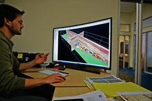
Jared Kluesner displays a 3D view of seismic data

Detailed Description
Jared Kluesner displays a 3D view of seismic data collected off Santa Barbara. This visualization helps him analyze the Earth’s layers from the seafloor (rainbow-colored surface) to several kilometers below (slices extending down from the colored surface).
Sources/Usage
Public Domain.
Related

Underwater Landslides off Southern California
An earthquake can trigger a landslide along the ocean floor, which can then set off a tsunami. Without modern, high-resolution imaging of the seafloor, many historical slides and threats from future slides remain undetected.

Coastal and Marine Geohazards of the U.S. West Coast and Alaska
Coastal and marine geohazards are sudden and extreme events beneath the ocean that threaten coastal populations. These underwater hazards include earthquakes, volcanic eruptions, landslides, and tsunamis. The tectonically active west coast of the Americas is prone to such hazards, as it lies along the boundaries of major tectonic plates that make up the Earth's crust—the North American, Caribbean...
Related
Underwater Landslides off Southern California
An earthquake can trigger a landslide along the ocean floor, which can then set off a tsunami. Without modern, high-resolution imaging of the seafloor, many historical slides and threats from future slides remain undetected.
Coastal and Marine Geohazards of the U.S. West Coast and Alaska
Coastal and marine geohazards are sudden and extreme events beneath the ocean that threaten coastal populations. These underwater hazards include earthquakes, volcanic eruptions, landslides, and tsunamis. The tectonically active west coast of the Americas is prone to such hazards, as it lies along the boundaries of major tectonic plates that make up the Earth's crust—the North American, Caribbean...