
Landsat 5 First Light Image of Corpus Christi, Texas

Detailed Description
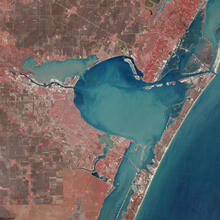
On March 6, 1984, the Thematic Mapper (TM) on Landsat 5 captured this image of Corpus Christi. Texas. Located in South Texas on the Gulf of America, the city and its bay are protected by barrier islands.
The image is shown as a false color composite using the near infrared, red, and green bands (bands 4,3,2). In this image vegetation appears as red and barren ground appears as brown.
Learn more about the mission by visiting the Landsat 5 web page
Sources/Usage
Public Domain.
Related

Landsat 5 First Light Image over South Texas Gulf Coast
One of the first Landsat 5 images in the archive shows Corpus Christi and Padre Island National Seashore. The image was acquired on March 6, 1984 and is shown as a false color composite using the near infrared, red, and green bands (bands 4,3,2). Learn more about the mission on the Landsat 5 web page
Related
Landsat 5 First Light Image over South Texas Gulf Coast
One of the first Landsat 5 images in the archive shows Corpus Christi and Padre Island National Seashore. The image was acquired on March 6, 1984 and is shown as a false color composite using the near infrared, red, and green bands (bands 4,3,2). Learn more about the mission on the Landsat 5 web page