
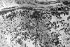
Landsat 8 Thermal Infrared Sensor Image near Ogallala, Nebraska

Detailed Description
Landsat 8 thermal infrared (Band 10) image near Ogallala, Nebraska, showing fields with center pivot irrigation. The Thermal Infrared Sensor (TIRS) on Landsat 8-9 measures energy radiated by the earth of the surface with two spectral bands that can be used to derive surface temperature.
The image was acquired on August 17, 2021 from Path 31 Row 32.
Sources/Usage
Public Domain.
Related
Landsat 8 thermal infrared sensor scene select mechanism open loop operations Landsat 8 thermal infrared sensor scene select mechanism open loop operations
The Landsat 8 (L8) spacecraft and its two instruments, the operational land imager (OLI) and thermal infrared sensor (TIRS), have been consistently characterized and calibrated since its launch in February 2013. These performance metrics and calibration updates are determined through the United States Geological Survey (USGS) Landsat image assessment system (IAS), which has been...
Authors
Michael J. Choate, R. Rengarajan, James C. Storey, Tim Beckmann
Landsat 8 thermal infrared sensor geometric characterization and calibration Landsat 8 thermal infrared sensor geometric characterization and calibration
The Landsat 8 spacecraft was launched on 11 February 2013 carrying two imaging payloads: the Operational Land Imager (OLI) and the Thermal Infrared Sensor (TIRS). The TIRS instrument employs a refractive telescope design that is opaque to visible wavelengths making prelaunch geometric characterization challenging. TIRS geometric calibration thus relied heavily on on-orbit measurements...
Authors
James C. Storey, Mike Choate, Donald Moe
Dark and background response stability for the Landsat 8 Thermal Infrared Sensor Dark and background response stability for the Landsat 8 Thermal Infrared Sensor
The Thermal Infrared Sensor (TIRS) is a pushbroom sensor that will be a part of the Landsat Data Continuity Mission (LDCM), which is a joint mission between NASA and the USGS. The TIRS instrument will continue to collect the thermal infrared data that are currently being collected by the Thematic Mapper and the Enhanced Thematic Mapper Plus on Landsats 5 and 7, respectively. One of the...
Authors
Kelly Vanderwerff, Matthew Montanaro