
Location and Climate of Gulkana Glacier
Detailed Description
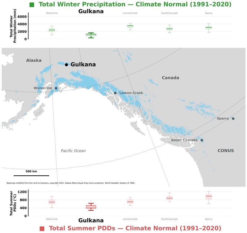
Fig. 1. Top panel shows, Benchmark Glacier total winter precipitation at the median elevation of each glacier, based on local weather station data (O'Neel et al., 2019), for the 1991 – 2020 climate normal period. Map shows the location of Gulkana Glaciers (large black dot) among the Benchmark Glacier network (smaller black dots). Glaciers of the Contiguous United States (CONUS), Canada, and Alaska shown in blue (Randolph Glacier Inventory, 2017). Bottom panel shows, Benchmark Glacier total summer positive degree days at the median elevation of each glacier, based on local weather station data (O'Neel et al., 2019), for the 1991 – 2020 climate normal period.
Sources/Usage
Public Domain.
Related

Glaciers and Landscape Change
Mountain glaciers are dynamic reservoirs of frozen water, deeply interconnected with their surrounding ecosystems. Glacier change in North America has major societal impacts, including to water resources, natural hazard risk, tourism disruption, fisheries, and global sea level change. Understanding and quantifying precise connections between changing glaciers, the surrounding landscape and climate...

Gulkana Glacier
Gulkana Glacier is located in the high-latitude continental climate regime of Alaska’s Delta Mountains. Glacier observations began at this site in 1966 and continue through present as the northern most USGS Benchmark Glacier.
Related
Glaciers and Landscape Change
Mountain glaciers are dynamic reservoirs of frozen water, deeply interconnected with their surrounding ecosystems. Glacier change in North America has major societal impacts, including to water resources, natural hazard risk, tourism disruption, fisheries, and global sea level change. Understanding and quantifying precise connections between changing glaciers, the surrounding landscape and climate...
Gulkana Glacier
Gulkana Glacier is located in the high-latitude continental climate regime of Alaska’s Delta Mountains. Glacier observations began at this site in 1966 and continue through present as the northern most USGS Benchmark Glacier.