
Ablation stakes on Gulkana Glacier, Alaska. Late summer fieldwork on Gulkana Glacier reveals ablation stakes emerging from the ice. Measurements of the change in the height of the snow and ice at these stakes is one aspect of determining glacier mass balance.
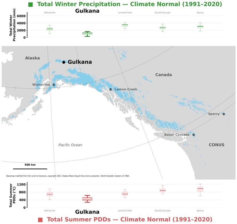
Gulkana Glacier is located in the high-latitude continental climate regime of Alaska’s Delta Mountains. Glacier observations began at this site in 1966 and continue through present as the northern most USGS Benchmark Glacier.
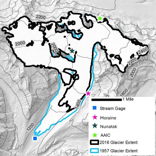
Gulkana Glacier lies along the south flank of the eastern Alaska Range’s Delta Mountains, in a continental climate characterized by cooler summer temperatures, and lower total winter precipitation compared to the other USGS Benchmark Glaciers. The main trunk has a southerly aspect and is fed by four cirques facing west, south, and east. The glacier spans 1,300 m of elevation, ranging from 1,160 to 2,470 m, within a 31.5 km² basin. As of 2016, the glacier covered an area of 16.0 km² (O'Neel et al., 2019).
Sources/Usage: Public Domain. View Media Details

Media
Sources/Usage: Public Domain. View Media Details
Glacier Mass Balance
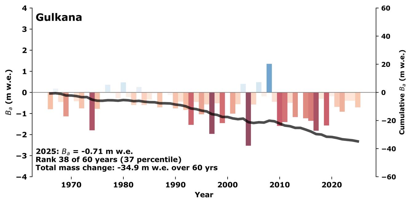
Mass balance measurements at Gulkana Glacier began in the early 1960s under the University of Alaska Gulkana Glacier Project (Péwé and Reger 1983). In 1966 as part of the International Hydrological decade, USGS scientists began collecting mass balance, meteorological, and hydrological data at Gulkana Glacier. Today measurements at Gulkana Glacier constitute one of the longest continuous mass balance records in North America, providing insight into snow and ice dynamics, hydrology, and the regional impacts of glacier change.
Media
Sources/Usage: Public Domain. View Media Details
Field visits to measure and maintain stakes at mass balance sites occur each spring at the onset of the melt season, and again in early autumn near its end. Snow pits or cores are collected to measure the density of material gained or lost. By timing visits near the balance maxima and minima, measurements closely capture maximum winter accumulation and annual balance at each location. Beginning in 1975, additional surveying of mass balance stakes provides both ice velocity and surface elevation change at each site.
From 1966 through the mid-1970's, mass balance studies were relatively extensive, before being reduced to three sites dispersed across the glacier’s elevation. Since 2009, the number of mass balance measurements have increased to improve spatial variability sampling and account for changes to the glacier.
Still today, field measurements are combined with weather data and imagery analysis to calculate seasonal and annual glacier-wide mass balance. These data are published through an official USGS data release and submitted to the World Glacier Monitoring Service. The most recent mass balance results are available on the executive summary webpage. For more detailed description of methods see: O’Neel et al., 2019 and Florentine et al., 2023.
Media
Sources/Usage: Public Domain. View Media Details
Meteorologic
Meteorological observations began in 1967 with temperature and precipitation measured at a weather station on the east lateral moraine (Moraine). In 2012 two additional weather stations were installed: one a centrally located nunatak near the mean ELA (Nunatak), and another at a ridge-top site above the main branch of the glacier (AAIC). In 2022 the Moraine weather station site was abandoned for safety concerns. Since then, Nunatak has served as the primary weather station at Gulkana Glacier. Continuous additions and upgrades to the sensor network have occurred over the years and now include mechanically aspirated temperature, relative humidity, solar radiation, and modern, radar-based precipitation quantity and type.
Media
Sources/Usage: Public Domain. View Media Details
The Nunatak weather station (Latitude 63°17'N, Longitude 145°26'W) is located on bedrock between the main trunk and a western cirque at 1725 m. This elevation is very near that of the glacier's long term average equilibrium line altitude (ELA) of 1,735 m. The average annual air temperature at the site is about -4 degrees Celsius(°C), and measured average annual precipitation is about 1,000 millimeters (mm). Snowfall is the dominant form of precipitation and usually accumulates on the glacier from September through mid-June. Daily average temperatures range from a low of -31°C to a high of 15°C. Daily precipitation catch can be over 100 mm.
The telemetered subset of current data can be viewed at (USGS Monitoring Location 15478036). The complete archive of quality checked data is updated regularly and can be found within the USGS Glacier Project Weather Station data release. Current measurements include:
- Passive Air Temperature
- Mechanically Aspirated air Temperature
- Precipitation
- Precipitation Type
- Relative Humidity
- Wind Speed
- Wind gust Speed
- Wind Direction
- Net Radiation
- Incoming and Outgoing Short-wave Radiation
- Incoming and Outgoing Longwave Radiation
Other Stations
Media

Sources/Usage: Public Domain. View Media Details
The original Gulkana Glacier Moraine weather station (latitude 63°16'N, longitude 145°25'W) was located at an altitude of 1480 m on the crest of a wind-swept, ice-cored moraine along the eastern boundary of the glacier approximately 300 m from the east edge of the glacier. Archived data for this site is available in the USGS Glacier Project Weather Station data release. Available data includes:
- Passive Air Temperature
- Wind speed
- Wind direction
- Wind gust speed
- Cumulative Precipitation
The AAIC weather station (Latitude 63°18'N, Longitude 145°24'W) has operated intermittently since 2012. It is located north of the main branch of the glacier at 1925 m on the divide between the Gulkana and Canwell glaciers. This site is currently operated by the Alaska Avalanche Information Center as the winter hazards station AGW01. They support telemetry of:
- Passive Air Temperature
- Relative Humidity
- Wind Speed
- Wind gust speed
- Wind Direction
Hydrologic
The USGS maintains a gaging station on Phelan Creek downstream of the glacier terminus. Stream data collection and analysis are conducted by standard techniques developed by the USGS. Current telemetered data, statistics (annual, daily, monthly means), and archived historical data can be viewed and downloaded at the water data for the nation website: USGS Monitoring Location 15478040
Location: Latitude: 63°14'25"N, Longitude: 145°28'05"W., 1,127 m altitude, in SW 1/4 sec.28, T.19 S., R.12 E., Hydrologic Unit 19080304, on left bank about 2.5 km downstream from terminus of Gulkana Glacier and 23 km north of Paxson, Alaska.
Drainage Area: 31 km2
Period of Record: October 1966 to September 1978, October 1989 to September 1993, October 1994 to current year, and annual maximums, water years 1984-85. Before October 1968, published as Gulkana Creek near Paxson.
Accuracy: Records are considered fair to poor. The creek bed is composed of typical ground-moraine material: poorly-sorted gravel and small boulders. The channel is subject to frequent changes during high flows. Large fluctuations result from ice melt and alternate damming and storage release during melt season.
Discharge: Typical summer discharge ranges between 4 and 10 m3/s (interquartile range of instantaneous values); the period-of-record peak discharge is 87 m3/s, winter mean discharge is about 0.12 m3/s, and winter minimum under-ice discharge is about 0.05 m3/s. The winter minimum discharge is about three to four times the average contribution from the combined geothermal melt of the bed of the glacier and melting caused by the loss of potential energy from ice motion (March, 2000).

Glaciers and Landscape Change
Mountain glaciers are dynamic reservoirs of frozen water, deeply interconnected with their surrounding ecosystems. Glacier change in North America has major societal impacts, including to water resources, natural hazard risk, tourism disruption, fisheries, and global sea level change. Understanding and quantifying precise connections between changing glaciers, the surrounding landscape and climate...
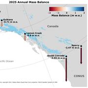
2025 USGS Benchmark Glaciers Executive Summary
2025 Data Now Available: Explore how the USGS Benchmark Glaciers have changed in 2025

Mass Balance Methods: Measuring Glacier Change
Nearly all of Earth's alpine glaciers are losing mass, with consequences for freshwater resources, landscape stability, regional ecosystems, and global sea level. Rates of glacier mass loss in Western North America and Alaska are among the highest on Earth (The GlaMBIE Team, 2025).

Additional Research Glaciers
The USGS Glacier Project has conducted research beyond the Benchmark Glaciers, both past and present. This work has focused on infrastructure hazards, rapid glacier change, landscape destabilization, and glacier dynamics and processes not captured by the Benchmark Glacier network. These glaciers include Black Rapids, Kahiltna, Kennicott, Columbia, Hubbard, and Taku.

Wolverine Glacier
Wolverine Glacier is located in the high-latitude maritime climate regime of Alaska’s Kenai Mountains. Glacier observations began at this site in 1966.
Lemon Creek Glacier
Lemon Creek Glacier is located in the high-latitude maritime region of Alaska, at the southernmost tip of the Juneau Icefield. Glacier observations began at this site in 1953.
South Cascade Glacier
South Cascade Glacier is located in the midlatitude maritime climate of the North Cascade Mountains of Washington State. Glacier observations began at this site in 1958.

Sperry Glacier
Sperry Glacier is located along the Continental Divide within Glacier National Park, Montana. It represents the midlatitude continental or transitional climate. Glacier observations began at this site in 2005.

Ablation stakes on Gulkana Glacier
Ablation stakes on Gulkana Glacier, Alaska. Late summer fieldwork on Gulkana Glacier reveals ablation stakes emerging from the ice. Measurements of the change in the height of the snow and ice at these stakes is one aspect of determining glacier mass balance.

Collecting Field Data at Gulkana Glacier
USGS scientists collect field data at Gulkana Glacier in the eastern Alaska Range. The checkerboard sampling pattern in the foreground indicates where snow pit density measurements were collected.
USGS scientists collect field data at Gulkana Glacier in the eastern Alaska Range. The checkerboard sampling pattern in the foreground indicates where snow pit density measurements were collected.

Gulkana Glacier weather station
A scientist checks data collection on multiple sensors at the Gulkana Glacier weather station where snow blankets the glacier surface.
A scientist checks data collection on multiple sensors at the Gulkana Glacier weather station where snow blankets the glacier surface.

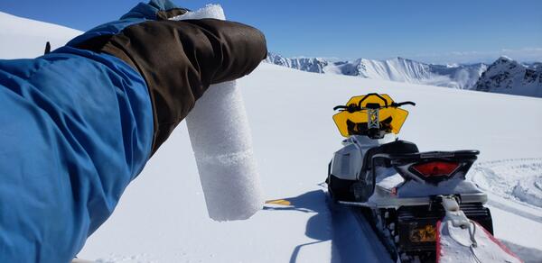
Firn core with an ice lens collected on Gulkana Glacier, Alaska.
Firn core with an ice lens collected on Gulkana Glacier, Alaska.Firn core with an ice lens collected on Gulkana Glacier during spring 2019 mass balance field work. Gulkana Glacier is located along the south flank of the eastern Alaska Range.

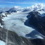
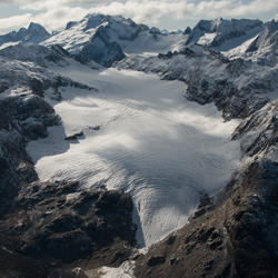
Gulkana Glacier
Gulkana Glacier is located along the south flank of the eastern Alaska Range.
Gulkana Glacier is located along the south flank of the eastern Alaska Range.

Gulkana Glacier
Heavily crevassed glacial ice flows across scoured rock in late summer at Gulkana Glacier, AK.
Heavily crevassed glacial ice flows across scoured rock in late summer at Gulkana Glacier, AK.

Crevassed terminus of Gulkana Glacier
Heavily crevassed terminus of Gulkana Glacier, AK, near the end of the 2016 ablation (melt) season.
Heavily crevassed terminus of Gulkana Glacier, AK, near the end of the 2016 ablation (melt) season.

Scientist in deep snow pit
Spring fieldwork on the Benchmark Glaciers involves digging deep snow pits to measure the density profile of the surface snowpack.
Spring fieldwork on the Benchmark Glaciers involves digging deep snow pits to measure the density profile of the surface snowpack.

The Gulkana Glacier weather station
The Gulkana Glacier weather station collects data on air temperature, wind speed and direction, and cumulative precipitation.
The Gulkana Glacier weather station collects data on air temperature, wind speed and direction, and cumulative precipitation.
Gulkana Glacier is located in the high-latitude continental climate regime of Alaska’s Delta Mountains. Glacier observations began at this site in 1966 and continue through present as the northern most USGS Benchmark Glacier.
Gulkana Glacier lies along the south flank of the eastern Alaska Range’s Delta Mountains, in a continental climate characterized by cooler summer temperatures, and lower total winter precipitation compared to the other USGS Benchmark Glaciers. The main trunk has a southerly aspect and is fed by four cirques facing west, south, and east. The glacier spans 1,300 m of elevation, ranging from 1,160 to 2,470 m, within a 31.5 km² basin. As of 2016, the glacier covered an area of 16.0 km² (O'Neel et al., 2019).
Sources/Usage: Public Domain. View Media Details
Media
Sources/Usage: Public Domain. View Media Details
Glacier Mass Balance
Mass balance measurements at Gulkana Glacier began in the early 1960s under the University of Alaska Gulkana Glacier Project (Péwé and Reger 1983). In 1966 as part of the International Hydrological decade, USGS scientists began collecting mass balance, meteorological, and hydrological data at Gulkana Glacier. Today measurements at Gulkana Glacier constitute one of the longest continuous mass balance records in North America, providing insight into snow and ice dynamics, hydrology, and the regional impacts of glacier change.
Media
Sources/Usage: Public Domain. View Media Details
Field visits to measure and maintain stakes at mass balance sites occur each spring at the onset of the melt season, and again in early autumn near its end. Snow pits or cores are collected to measure the density of material gained or lost. By timing visits near the balance maxima and minima, measurements closely capture maximum winter accumulation and annual balance at each location. Beginning in 1975, additional surveying of mass balance stakes provides both ice velocity and surface elevation change at each site.
From 1966 through the mid-1970's, mass balance studies were relatively extensive, before being reduced to three sites dispersed across the glacier’s elevation. Since 2009, the number of mass balance measurements have increased to improve spatial variability sampling and account for changes to the glacier.
Still today, field measurements are combined with weather data and imagery analysis to calculate seasonal and annual glacier-wide mass balance. These data are published through an official USGS data release and submitted to the World Glacier Monitoring Service. The most recent mass balance results are available on the executive summary webpage. For more detailed description of methods see: O’Neel et al., 2019 and Florentine et al., 2023.
Media
Sources/Usage: Public Domain. View Media Details
Meteorologic
Meteorological observations began in 1967 with temperature and precipitation measured at a weather station on the east lateral moraine (Moraine). In 2012 two additional weather stations were installed: one a centrally located nunatak near the mean ELA (Nunatak), and another at a ridge-top site above the main branch of the glacier (AAIC). In 2022 the Moraine weather station site was abandoned for safety concerns. Since then, Nunatak has served as the primary weather station at Gulkana Glacier. Continuous additions and upgrades to the sensor network have occurred over the years and now include mechanically aspirated temperature, relative humidity, solar radiation, and modern, radar-based precipitation quantity and type.
Media
Sources/Usage: Public Domain. View Media Details
The Nunatak weather station (Latitude 63°17'N, Longitude 145°26'W) is located on bedrock between the main trunk and a western cirque at 1725 m. This elevation is very near that of the glacier's long term average equilibrium line altitude (ELA) of 1,735 m. The average annual air temperature at the site is about -4 degrees Celsius(°C), and measured average annual precipitation is about 1,000 millimeters (mm). Snowfall is the dominant form of precipitation and usually accumulates on the glacier from September through mid-June. Daily average temperatures range from a low of -31°C to a high of 15°C. Daily precipitation catch can be over 100 mm.
The telemetered subset of current data can be viewed at (USGS Monitoring Location 15478036). The complete archive of quality checked data is updated regularly and can be found within the USGS Glacier Project Weather Station data release. Current measurements include:
- Passive Air Temperature
- Mechanically Aspirated air Temperature
- Precipitation
- Precipitation Type
- Relative Humidity
- Wind Speed
- Wind gust Speed
- Wind Direction
- Net Radiation
- Incoming and Outgoing Short-wave Radiation
- Incoming and Outgoing Longwave Radiation
Other Stations
Media
Sources/Usage: Public Domain. View Media Details
The original Gulkana Glacier Moraine weather station (latitude 63°16'N, longitude 145°25'W) was located at an altitude of 1480 m on the crest of a wind-swept, ice-cored moraine along the eastern boundary of the glacier approximately 300 m from the east edge of the glacier. Archived data for this site is available in the USGS Glacier Project Weather Station data release. Available data includes:
- Passive Air Temperature
- Wind speed
- Wind direction
- Wind gust speed
- Cumulative Precipitation
The AAIC weather station (Latitude 63°18'N, Longitude 145°24'W) has operated intermittently since 2012. It is located north of the main branch of the glacier at 1925 m on the divide between the Gulkana and Canwell glaciers. This site is currently operated by the Alaska Avalanche Information Center as the winter hazards station AGW01. They support telemetry of:
- Passive Air Temperature
- Relative Humidity
- Wind Speed
- Wind gust speed
- Wind Direction
Hydrologic
The USGS maintains a gaging station on Phelan Creek downstream of the glacier terminus. Stream data collection and analysis are conducted by standard techniques developed by the USGS. Current telemetered data, statistics (annual, daily, monthly means), and archived historical data can be viewed and downloaded at the water data for the nation website: USGS Monitoring Location 15478040
Location: Latitude: 63°14'25"N, Longitude: 145°28'05"W., 1,127 m altitude, in SW 1/4 sec.28, T.19 S., R.12 E., Hydrologic Unit 19080304, on left bank about 2.5 km downstream from terminus of Gulkana Glacier and 23 km north of Paxson, Alaska.
Drainage Area: 31 km2
Period of Record: October 1966 to September 1978, October 1989 to September 1993, October 1994 to current year, and annual maximums, water years 1984-85. Before October 1968, published as Gulkana Creek near Paxson.
Accuracy: Records are considered fair to poor. The creek bed is composed of typical ground-moraine material: poorly-sorted gravel and small boulders. The channel is subject to frequent changes during high flows. Large fluctuations result from ice melt and alternate damming and storage release during melt season.
Discharge: Typical summer discharge ranges between 4 and 10 m3/s (interquartile range of instantaneous values); the period-of-record peak discharge is 87 m3/s, winter mean discharge is about 0.12 m3/s, and winter minimum under-ice discharge is about 0.05 m3/s. The winter minimum discharge is about three to four times the average contribution from the combined geothermal melt of the bed of the glacier and melting caused by the loss of potential energy from ice motion (March, 2000).
Glaciers and Landscape Change
Mountain glaciers are dynamic reservoirs of frozen water, deeply interconnected with their surrounding ecosystems. Glacier change in North America has major societal impacts, including to water resources, natural hazard risk, tourism disruption, fisheries, and global sea level change. Understanding and quantifying precise connections between changing glaciers, the surrounding landscape and climate...
2025 USGS Benchmark Glaciers Executive Summary
2025 Data Now Available: Explore how the USGS Benchmark Glaciers have changed in 2025
Mass Balance Methods: Measuring Glacier Change
Nearly all of Earth's alpine glaciers are losing mass, with consequences for freshwater resources, landscape stability, regional ecosystems, and global sea level. Rates of glacier mass loss in Western North America and Alaska are among the highest on Earth (The GlaMBIE Team, 2025).
Additional Research Glaciers
The USGS Glacier Project has conducted research beyond the Benchmark Glaciers, both past and present. This work has focused on infrastructure hazards, rapid glacier change, landscape destabilization, and glacier dynamics and processes not captured by the Benchmark Glacier network. These glaciers include Black Rapids, Kahiltna, Kennicott, Columbia, Hubbard, and Taku.
Wolverine Glacier
Wolverine Glacier is located in the high-latitude maritime climate regime of Alaska’s Kenai Mountains. Glacier observations began at this site in 1966.
Lemon Creek Glacier
Lemon Creek Glacier is located in the high-latitude maritime region of Alaska, at the southernmost tip of the Juneau Icefield. Glacier observations began at this site in 1953.
South Cascade Glacier
South Cascade Glacier is located in the midlatitude maritime climate of the North Cascade Mountains of Washington State. Glacier observations began at this site in 1958.
Sperry Glacier
Sperry Glacier is located along the Continental Divide within Glacier National Park, Montana. It represents the midlatitude continental or transitional climate. Glacier observations began at this site in 2005.
Ablation stakes on Gulkana Glacier
Ablation stakes on Gulkana Glacier, Alaska. Late summer fieldwork on Gulkana Glacier reveals ablation stakes emerging from the ice. Measurements of the change in the height of the snow and ice at these stakes is one aspect of determining glacier mass balance.
Ablation stakes on Gulkana Glacier, Alaska. Late summer fieldwork on Gulkana Glacier reveals ablation stakes emerging from the ice. Measurements of the change in the height of the snow and ice at these stakes is one aspect of determining glacier mass balance.
Collecting Field Data at Gulkana Glacier
USGS scientists collect field data at Gulkana Glacier in the eastern Alaska Range. The checkerboard sampling pattern in the foreground indicates where snow pit density measurements were collected.
USGS scientists collect field data at Gulkana Glacier in the eastern Alaska Range. The checkerboard sampling pattern in the foreground indicates where snow pit density measurements were collected.
Gulkana Glacier weather station
A scientist checks data collection on multiple sensors at the Gulkana Glacier weather station where snow blankets the glacier surface.
A scientist checks data collection on multiple sensors at the Gulkana Glacier weather station where snow blankets the glacier surface.
Firn core with an ice lens collected on Gulkana Glacier, Alaska.
Firn core with an ice lens collected on Gulkana Glacier, Alaska.Firn core with an ice lens collected on Gulkana Glacier during spring 2019 mass balance field work. Gulkana Glacier is located along the south flank of the eastern Alaska Range.
Gulkana Glacier
Gulkana Glacier is located along the south flank of the eastern Alaska Range.
Gulkana Glacier is located along the south flank of the eastern Alaska Range.
Gulkana Glacier
Heavily crevassed glacial ice flows across scoured rock in late summer at Gulkana Glacier, AK.
Heavily crevassed glacial ice flows across scoured rock in late summer at Gulkana Glacier, AK.
Crevassed terminus of Gulkana Glacier
Heavily crevassed terminus of Gulkana Glacier, AK, near the end of the 2016 ablation (melt) season.
Heavily crevassed terminus of Gulkana Glacier, AK, near the end of the 2016 ablation (melt) season.
Scientist in deep snow pit
Spring fieldwork on the Benchmark Glaciers involves digging deep snow pits to measure the density profile of the surface snowpack.
Spring fieldwork on the Benchmark Glaciers involves digging deep snow pits to measure the density profile of the surface snowpack.
The Gulkana Glacier weather station
The Gulkana Glacier weather station collects data on air temperature, wind speed and direction, and cumulative precipitation.
The Gulkana Glacier weather station collects data on air temperature, wind speed and direction, and cumulative precipitation.