
Nantucket Sound's Seafloor

Detailed Description
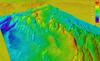
The Woods Hole Coastal and Marine Science Center Sea Floor Mapping Group is mapping the seafloor and subseafloor of Nantucket Sound as part of a long-term collaboration with the State of Massachusetts. This is an image of Nantucket Sound's seafloor. It is dominated by sand waves. Data are collected at such quality that we can even resolve the ripples on top of the sand waves. These bedforms indicate a very mobile and sandy seafloor.
Sources/Usage
Public Domain.